I was one of the lucky few to have off today for Columbus Day. Noelle, Sierra and I took advantage of my day off (and a rare dry day) to do some hiking aver at Ijams Nature Center in Knoxville again. This time we wanted to see the Ross Marble Quarry where the workers stacked spoils rock to form a bridge and tunnel.
The drive into Knoxville was uneventful. We stopped by the nature center to use the restroom and look at the animals. We then drove a little further down Island Home Pike to the trailhead for Mead's Quarry and the Ross Marble Quarry. We headed off on some abandoned railroad tracks and then on Imerys Trail. The autumn color has not yet peaked here, but there was some color in the leaves to make the hike interesting. Soon we found ourselves at a trail intersection with a sign for the Ross Marble Quarry.
We opted to head over to the rockbridge and keyhole. The rock bridge was cool from the top.
It offered a nice view out and over the quarry. Once we had crossed over, the trail descended on wet, slippery leaf-covered rocks to the keyhole.
It was much as it looked in the photos I had seen of it.
We passed through the keyhole
and as we made our way into the quarry we found we were not alone. We saw a box turtle making his way across the floor of the quarry through the vegetation.
We watched the turtle for a bit and then explored the floor of the quarry a bit.
We went as far as a fenced off cave in which we could hear flowing water, then we turned around and headed back through the keyhole. Once on the other side of the keyhole we completed a short loop by taking a different trail from the one that had crossed the rockbridge.
We arrived back at the trail intersection we had stopped at earlier and then proceeded to head into the quarry again, this time via the Hayworth Hollow Trail.
The Hayworth Hollow Trail was like a trip down into a sheer walled canyon. Cut stone lie scattered everywhere, most of it covered with thick green moss. We made it to the end of the trail
and turned around to head back to the car. Just before reaching the parking lot we stopped to inspect the site of the old limekilns.
Besides the industrial relics, we saw a monarch butterfly on the blooms of some butterfly bush.
Then we walked the old railroad tracks
back to the car for our drive over to the zoo.
Monday, October 13, 2014
Monday, October 6, 2014
Sunday, October 5, 2014
Buffalo Mountain Park: Hike to White Rock Overlook
Another beautiful day in East Tennessee! The whole family set out to enjoy the weather and get some fresh air. We decided to head up to Johnson City to eat at the relatively new Tupelo Honey Cafe there, go for a hike at Buffalo Mountain Park and get ourselves a pumpkin on the way home. The food at THC was delicious like last time we ate there in Knoxville. A bonus to the Johnson City restaurant is the fact that it is in an old train station with lots of train memorabilia on the walls and a model train display to look at. Sierra loved the train display!
After our lunch we were ready to burn off some calories. We drove into Buffalo Mountain Park and parked at the alternate trailhead for our hike up to White Rock.
The hike started off pretty steep.
We climbed until we reached a ridge and then things leveled off a little bit. There was a bit of color.
Mostly the red of some sourwood trees.
We kept making our way up the trail and stopped to take a short break for some photos.
Shortly after resuming our march, we found ourselves at the first overlook where we stopped to admire the view and take some photos.
From the first overlook the trail climbed gradually, arriving at the White Rock Overlook after a short distance. Again we admired the view and took some photos.
This overlook we shared with lots of others including a guy resting in a hammock he had secured between two trees. From the summit we decided to take the service road down instead of retracing our steps down the trail.
Taking the road gave me a bit of a break as it allowed Sierra to walk for a bit instead of me carrying her in the backpack. She made it about half way down the mountain before she got tired and we put her in the backpack. Before we knew it we were back at the car for our drive to the farm stand to get a pumpkin and some apple butter.
After our lunch we were ready to burn off some calories. We drove into Buffalo Mountain Park and parked at the alternate trailhead for our hike up to White Rock.
The hike started off pretty steep.
We climbed until we reached a ridge and then things leveled off a little bit. There was a bit of color.
Mostly the red of some sourwood trees.
We kept making our way up the trail and stopped to take a short break for some photos.
Shortly after resuming our march, we found ourselves at the first overlook where we stopped to admire the view and take some photos.
From the first overlook the trail climbed gradually, arriving at the White Rock Overlook after a short distance. Again we admired the view and took some photos.
This overlook we shared with lots of others including a guy resting in a hammock he had secured between two trees. From the summit we decided to take the service road down instead of retracing our steps down the trail.
Taking the road gave me a bit of a break as it allowed Sierra to walk for a bit instead of me carrying her in the backpack. She made it about half way down the mountain before she got tired and we put her in the backpack. Before we knew it we were back at the car for our drive to the farm stand to get a pumpkin and some apple butter.
Saturday, October 4, 2014
Great Smoky Mountains National Park: Boogerman Loop
After parking at the empty trailhead parking lot, I crossed a high log bridge over Cataloochee Creek. I then hiked along a pleasant, relatively-flat Caldwell Fork Trail
for a bit which, not surprisingly, closely followed and crossed Caldwell Fork.
After .8 mile and a ford of Caldwell Fork I was at the junction with the Boogerman Trail which I would follow for the next 3.8 miles.
Almost immediately I found myself gazing at a very large tree: a big tulip poplar. I took a photo of myself standing next to it and then moved on.
As I walked I realized there were lots of other big trees in the area but that most of them were dead.
I'm guessing these dead trees are hemlocks that have succumbed to the Hemlock Wooly Adelgid. From this first big tree I continued on up the trail which climbed a bit more than I had anticipated.
I followed a short but steep trail up to a mossy flat area that I assume is a cemetery. There were no headstones, but the flat cleared area covered with moss seems to be pretty typical of Smokies cemeteries.
Eventually I found another large tree, another tulip poplar, off to the side of the trail. Again I photographed myself standing in next to it.
This particular tree has one of the largest girths of any tree I have ever seen! I followed a user trail around the tree and found that the other side was hollowed out and so I took another photograph. This time I stood just inside the hollow tree.
The trail continued on into some signs of habitation. First there was a stone wall.
Then I found another hollow tree.
Soon after there was another wall with a trail leading up hill to a small, two grave cemetery.
I contemplated the solitude of the spot with its two anonymous, lonely graves and then headed back to the main trail where I continued on and soon found an old home site. There was a rusted piece of metal tool or old machinery
there which I guessed the purpose of for a bit, before giving up and heading over to the Caldwell Fork Trail.
The Caldwell Fork Trail crossed the fork several times. I knew there were some bridges out and had brought my sandals for the crossings. There only ended up being 3 wet crossings and 2 of them were actually the same crossing that I made two times.
Still, I didn't mind getting my feet wet on this chilly fall morning.
for a bit which, not surprisingly, closely followed and crossed Caldwell Fork.
After .8 mile and a ford of Caldwell Fork I was at the junction with the Boogerman Trail which I would follow for the next 3.8 miles.
Almost immediately I found myself gazing at a very large tree: a big tulip poplar. I took a photo of myself standing next to it and then moved on.
As I walked I realized there were lots of other big trees in the area but that most of them were dead.
I'm guessing these dead trees are hemlocks that have succumbed to the Hemlock Wooly Adelgid. From this first big tree I continued on up the trail which climbed a bit more than I had anticipated.
I followed a short but steep trail up to a mossy flat area that I assume is a cemetery. There were no headstones, but the flat cleared area covered with moss seems to be pretty typical of Smokies cemeteries.
Eventually I found another large tree, another tulip poplar, off to the side of the trail. Again I photographed myself standing in next to it.
This particular tree has one of the largest girths of any tree I have ever seen! I followed a user trail around the tree and found that the other side was hollowed out and so I took another photograph. This time I stood just inside the hollow tree.
The trail continued on into some signs of habitation. First there was a stone wall.
Then I found another hollow tree.
Soon after there was another wall with a trail leading up hill to a small, two grave cemetery.
I contemplated the solitude of the spot with its two anonymous, lonely graves and then headed back to the main trail where I continued on and soon found an old home site. There was a rusted piece of metal tool or old machinery
there which I guessed the purpose of for a bit, before giving up and heading over to the Caldwell Fork Trail.
The Caldwell Fork Trail crossed the fork several times. I knew there were some bridges out and had brought my sandals for the crossings. There only ended up being 3 wet crossings and 2 of them were actually the same crossing that I made two times.
Still, I didn't mind getting my feet wet on this chilly fall morning.
Great Smoky Mountains National Park: Cataloochee
What a day to be outside! Today was the first real day of fall here in East Tennessee. I'm glad I had the opportunity to enjoy it. I awoke this morning at 6 am and hit the road, headed towards the Great Smoky Mountains National Park. I stopped in Newport for a quick breakfast and then hopped on I-40 east. I had intended to get off the interstate at the exit for Big Creek and drive up to Mount Sterling Gap, but as the exit was not signed for Big Creek like I thought it would be, I passed right by it. The next exit is not for another 7 miles and rather than drive an extra 14 miles, I opted to head over to Cataloochee to explore the area and hike the Boogerman Loop. Missing my exit turned out to be a good mistake!
It was a long winding drive from I-40 to Cataloochee. Shortly after entering the park I was treated to some solitude at a really nice overlook of the valley and surrounding mountains.
I excitedly hopped back in the car and made the rest of the drive down into Cataloochee. Soon, I noticed a bunch of cars pulled of to the side of the road and lots of people standing by the roadside.
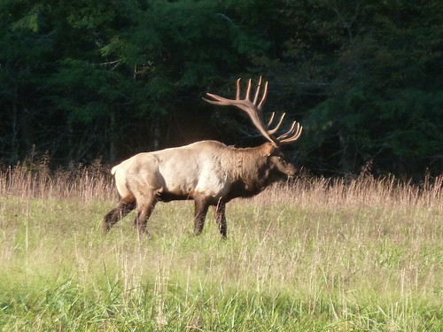
I correctly assumed that the park's elk herd was out.
I parked the car and walked over towards the wildlife (not too close though). I took a few shots of the elk,
including some big bulls with impressive racks of antlers and even heard a few bugle. After admiring the large animals for a bit I hopped back in the car and headed a short distance to the Palmer Chapel.
Palmer Chapel was an impressive, yet simple, church located at the edge of where the woods meet the fields.
I even went inside for a bit
and then checked out the chapel's cemetery across the street. Then I headed back to the car and drove to my next destination, the Beech Grove School.
I parked in a small gravel lot near the school and walked over to it. There were some turkeys in a field next to the school that I watched for a bit. Unfortunately, because they were in the shadows, I did not have enough light to photograph them. I then headed inside the school for a look around.
After Beech Grove School I headed further up the road to explore the Caldwell House. To get to the house you cross Rough Fork on a small wooden bridge.
The Caldwell House looks so much different than most of the other structures that have been preserved by the National Park Service in the park. For one, it is not a log structure, but painted white with blue trim.
There were lots of rooms to explore inside and some of the rooms still had their original newspaper insulation left on the walls.
There was also a nice view out of windows to the barn across the street.
After a stop at the springhouse,
I headed over towards the barn
and my car.
From the Caldwell House I drove back the way I came, squeezing past cars headed in the other direction. I was headed to the Boogerman Loop Trailhead for a walk into some big trees. After my hike I drove out of Cataloochee via the road that goes past the Palmer House.
I explored the house
and its outbuildings
a bit before getting back on the road. Instead of taking the interstate, I would drive the rough winding road that goes between Cataloochee and Big Creek. It was slow going, but a stop at a big rock off to the side of the road offered a nice view of the surrounding mountains.
Driving this road also offered me the opportunity to hike the easternmost mile of the Little Cataloochee Trail.
It was a long winding drive from I-40 to Cataloochee. Shortly after entering the park I was treated to some solitude at a really nice overlook of the valley and surrounding mountains.
I excitedly hopped back in the car and made the rest of the drive down into Cataloochee. Soon, I noticed a bunch of cars pulled of to the side of the road and lots of people standing by the roadside.
I correctly assumed that the park's elk herd was out.
I parked the car and walked over towards the wildlife (not too close though). I took a few shots of the elk,
including some big bulls with impressive racks of antlers and even heard a few bugle. After admiring the large animals for a bit I hopped back in the car and headed a short distance to the Palmer Chapel.
Palmer Chapel was an impressive, yet simple, church located at the edge of where the woods meet the fields.
I even went inside for a bit
and then checked out the chapel's cemetery across the street. Then I headed back to the car and drove to my next destination, the Beech Grove School.
I parked in a small gravel lot near the school and walked over to it. There were some turkeys in a field next to the school that I watched for a bit. Unfortunately, because they were in the shadows, I did not have enough light to photograph them. I then headed inside the school for a look around.
After Beech Grove School I headed further up the road to explore the Caldwell House. To get to the house you cross Rough Fork on a small wooden bridge.
The Caldwell House looks so much different than most of the other structures that have been preserved by the National Park Service in the park. For one, it is not a log structure, but painted white with blue trim.
There were lots of rooms to explore inside and some of the rooms still had their original newspaper insulation left on the walls.
There was also a nice view out of windows to the barn across the street.
After a stop at the springhouse,
I headed over towards the barn
and my car.
From the Caldwell House I drove back the way I came, squeezing past cars headed in the other direction. I was headed to the Boogerman Loop Trailhead for a walk into some big trees. After my hike I drove out of Cataloochee via the road that goes past the Palmer House.
I explored the house
and its outbuildings
a bit before getting back on the road. Instead of taking the interstate, I would drive the rough winding road that goes between Cataloochee and Big Creek. It was slow going, but a stop at a big rock off to the side of the road offered a nice view of the surrounding mountains.
Driving this road also offered me the opportunity to hike the easternmost mile of the Little Cataloochee Trail.
Subscribe to:
Posts (Atom)