Tuesday, September 22, 2020

Roosevelt National Forest: Greyrock Mountain

This is a hike I've been wanting to do for a while now. Unfortunately, the Cameron Peak Fire has pushed back this hike, until today. This morning I made the drive down into Colorado and onto Highway 14 along the Cache la Poudre River to the Greyrock Mountain Trailhead. I crossed the river 


on a footbridge and hit the trail 


with some light haze from wildfire smoke. 

The scenery was beautiful. 


I found a short trail that led to a memorial marker.

The last of 2020s wildflowers were in bloom; rabbitbrush and aster.


At the junction of the Meadow and Summit Trails, I opted to take the Summit Trail for the ascent.


As I ascended, views of the surrounding mountains started to open up around me.


I took a short break on a rock and shortly thereafter, caught my first view of Greyrock Mountain.


I would get plenty more views of this distinctive mountain over the course of the next few miles.


Soon, the smooth gravel trail ended and I would scramble the rest of the way up to the summit. 

The views continued to be excellent, if hazy from the Cameron Peak Fire.


Soon enough, I found myself at the summit. Surprisingly, I had it all to myself. I took a photo there,

rested a bit, and then started back down.

For the descent, I took the Greyrock Meadow Trail.

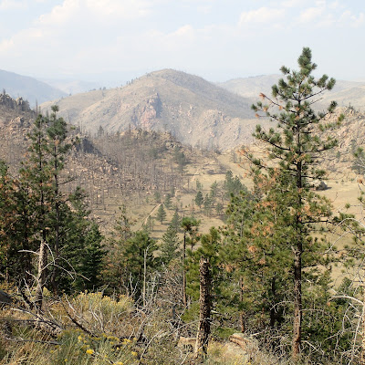
The views on this trail were often spectacular, especially when I looked back to Greyrock Mountain. 


It was not all downhill though, as there was quite a bit of unexpected ascent on the trail. Still, the wonderful scenery made up for the ascents.


Friday, September 18, 2020

Oglala National Grassland: Roundtop Peak

 After my ascent of Eagle Eye Rock, I made a short drive over to Toadstool Park and the start of my hike up Roundtop Peak. Toadstool Park and it's badlands formations was interesting as always, 


though I didn't spend a whole lot of time there. Instead I made my way on the Great Plains Trail through a short portion of it.

Even outside of Toadstool Park proper, there were plenty of badlands to walk through.


And where there are badlands, there are fossils to be found.

I made my way along the Great Plains Trail to a two-track road, 

where I made a left and crossed the grasslands. There were intermittent views out to more badlands 

and a group of scared cows.

After a short walk on the road, I headed off on the trail that leads to the Hudson-Meng Bison Bone Bed. I followed that trail for a bit and then headed cross country towards my objective for the hike: Roundtop Peak.
At its base, I climbed up the grassy slopes to the highest point, where I took a photo.

Then, I descended to a section of the road I had hiked earlier. I passed old storage tanks (for oil, maybe?) 

and followed the road back to the Bison Trail. 


Then I descended the Bison Trail back to Toadstool Park and the car. 

Thursday, September 17, 2020

Nebraska National Forest: Eagles Eye Rock

Today was another Nebraska peak-begging day. First on my list was an ascent of Eagles Eye Rock in the Nebraska National Forest near Hudson Meng Bison Bonebed. I made the drive out the gravel road to another road with an ominous warning sign. 


I parked nearby and started my hike up the road. 


Eventually the road ended and I came to a trail. 


Really the trail is just a section of the road that has been closed to vehicular traffic.  The trail climbed steeply and offered great view down to the plains below. 

At the top of the ridge the trail became less obvious, marked periodically by diamond blazes attached to posts.

There was a tangle of fallen trees at a bump of land. 


I assumed that this was the summit of Eagles Eye Rock and so I tagged the summit and then made my descent back to the car.

Wednesday, September 9, 2020

Fort Robinson State Park: Walter Reed Butte (and beyond)

After the day's earlier hike up to the Cheyenne Buttes, I got back in the car, drove the rest of the Scenic Road and then headed over to the Mexican Canyon Trailhead for my hike up to Walter Reed Butte. If you're wondering, yes, Walter Reed Butte is named after the famous Army doctor. Walter Reed was the post surgeon at Fort Robinson in the 1880s.

The hike started in a very scenic area.


 I hiked up a ridge on the west side of Mexican Canyon. 

There were great views down into the system of canyon and side drainages. 


As I hiked further and further up the ridge, I didn't see any obvious high points. In addition, the snow was starting to get deeper.

I decided I must have gone too far. I quick look at the GPS coordinates on my phone confirmed my suspicions. I turned around and made my way back towards where I had come. After a while I saw this bump on the right side of the trail. 


I had found Walter Reed Buttes and had walked about 4 extra miles in my search for it. I climbed up to the summit, took a photo 


and admired the view for a few minutes. 

Then, I started my return trip back to the car. On the way back I decided to hike a different way.


I hiked down into Mexican Canyon and hiked through the canyon and its tree cover back to the car.