Wednesday, August 26, 2020

Medicine Bow National Forest: Crater Lake and Lookout Mountain

 I had originally planned a 12 plus mile loop hike around Browns Peak today. However, when I awoke this morning, it was very windy. It didn't seem like fun conditions for a hike above the trees, and so I packed up my tent (a bit of a chore in the wind) and hit the road to lower elevations that I hoped would be protected from the wind. 

I headed east towards Centennial, but before leaving the National Forest I turned right and headed north towards the trailhead for Crater Lake. It was a pretty long drive to the trailhead, but very scenic. I saw some wildlife along the way: a couple of elk that were too quick to photograph and a pair of moose feeding along a creek.


I arrived at the trailhead and immediately hit the trail.


The first half of the route was very easy and extremely flat. I soon found myself at a high overlook of Crater Lake.

I took my photo at the overlook, 


then started the very steep descent to the lake. The lake itself was a very nice spot. I rested there for a bit.

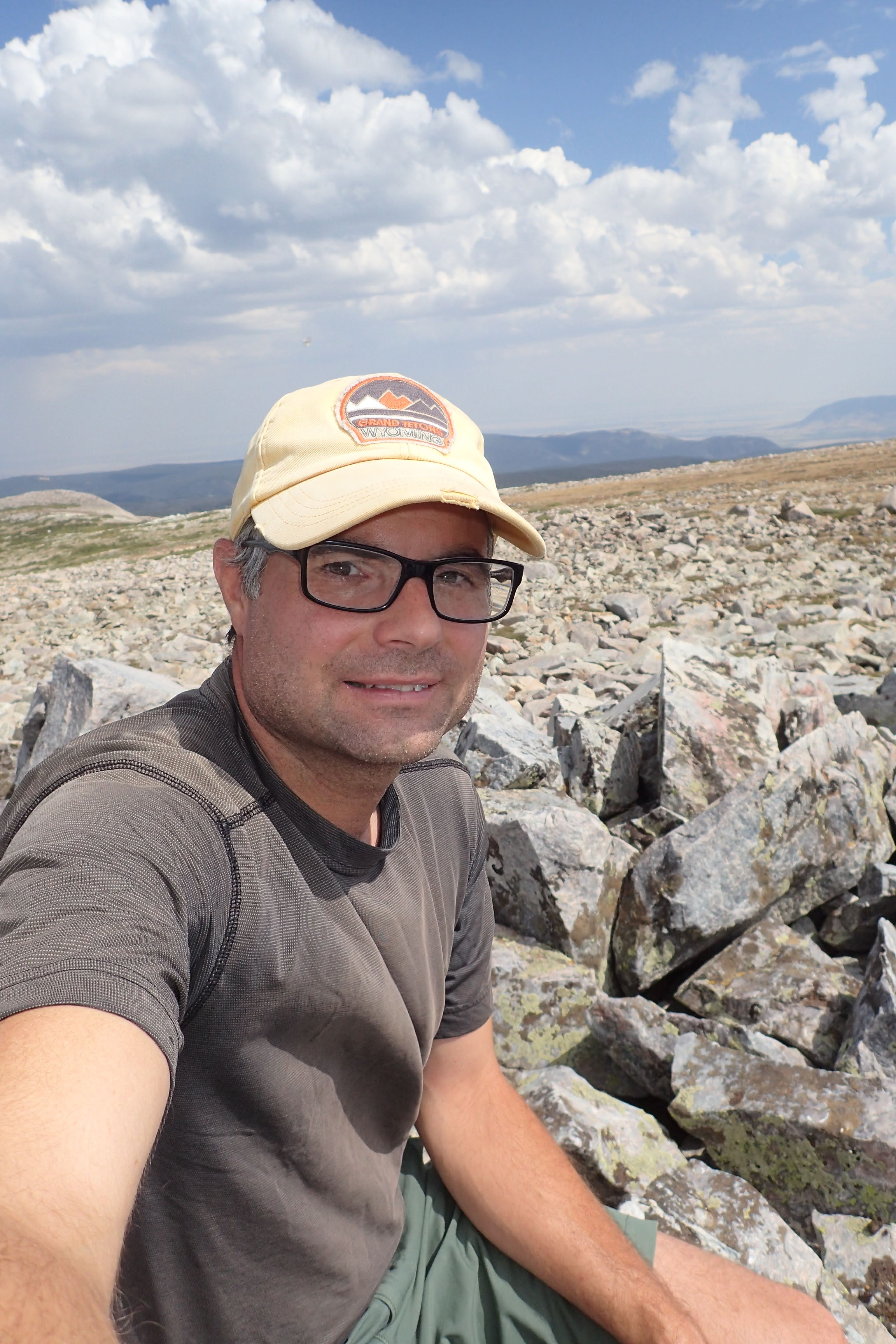
There wasn't much else to the lake though, so after a short time I was ready for the steep climb back up. It was tough going. Once I reached the ridge I found a spot marked by a few small cairns and took a side trip to what appeared to be the highest point around and the summit of Lookout Mountain. I snapped a selfie there 


and then headed back to the trailhead for my drive back home.

Tuesday, August 25, 2020

Medicine Bow National Forest: Peakbagging Sugarloaf Mountain and Browns Peak

With more hot weather forecast for my days off, I decided I had to get out of town and into the mountains. I decided I would head to the Snowy Range to bag a few peaks that I hadn't been on before. 

I hit the road early this morning, passed through Cheyenne and then followed I-80 west, following the route of the Old Lincoln Highway 


past Tree Rock 


and the highest point on Interstate 80. 


Shortly thereafter, I headed up into the mountains. I arrived at the Sugarloaf Campground just in time to claim the last remaining site. Then, I hit the trail headed towards my first objective for the day, an ascent of Sugarloaf Mountain. 

I started my hike on the Medicine Bow Peak Trail and closely followed the southern shoreline of Lewis Lake.


 At times I could see my second objective for the day, Browns Peak.


There were lots of wildflowers in bloom along the trail, and some pollinators as well.


At a trail junction, 


I left the trail and set off cross country on my ascent of Sugarloaf.

As I approached the summit, the views got better and better!

Soon enough, I was standing on top of the summit proper. 

I relaxed for a bit at a stone shelter 


and looked north out to some lakes and Browns Peak.

When it was time to move on, I retraced my steps back to the Lewis Lake parking area and set out on the North Gap Lake Trail.

 I could look back at awesome views of Sugarloaf!

I ascended to South Gap Lake.


Then, I hiked up to the ridge separating South and North Gap Lakes. Here I started my off trail ascent. It was steep and rocky, but I could stop every now and then and enjoy the views of South Gap Lake and the surrounding area.

I finally reached the large, relatively flat summit plateau. I explored a bit and determined the highest point to be a spot marked by a tall cairn near the middle of the plateau. I found a place to rest for a bit, 


then started my descent. I spied a few marmots on my way down.

By the time I rejoined the trail, I was utterly exhausted. I found a nice grassy spot near a small, unnamed pond and dozed off in the sun. 

When I was ready to start moving again, it was a short, downhill hike 


back to my campsite at the Sugarloaf Campground.

Wednesday, August 19, 2020

Gravel ride the Rifle Sight Pass Route

 It was forecast to be hot today, but I wanted to get out and do something. I opted to take the bike out for a spin and explore the local area by starting from home and heading to Rifle Sight Pass. 

I started my ride by crossing Five Rocks Road and following County Road P past the Five Rocks Amphitheater and up past the southern boundary of Scotts Bluff National Monument with nice views of Dome Rock.

After descending on a loose gravel section of road, I made a right turn onto Robidoux Road where I would spend a majority of the first half of the ride. At an old, faded sign for the Gering Valley Flood Control Project

I turned right onto Rifle Site Pass Road and began a steady climb on loose gravel. 


At the pass I began my descent and admired the surrounding formations.

The ride down to Highway 92 went fast, as it was all downhill. I had nice views of Scotts Bluff as I traveled the shoulder of the busy highway. A train rumbled west, ready to pick up a load of coal.

I stopped at the Fort Mitchell site.

I rested in the meager shade cast by one of the stone monuments.


 Then, I crossed the North Platte River,

where I caught a glimpse of a pair of osprey on a nesting platform.


From there I headed into Scottsbluff. 


Since I was out of water, I got a drink at the Western Travel Terminal before following the Monument Valley Pathway back through Terrytown and into Gering.

Saturday, August 15, 2020

Old West Balloon Fest Night Glow

Tonight the Old West Balloon Fest night glow was taking place at the field near the Five Rocks Amphitheater and so we decided to take a short walk across Five Rocks Road to check it out. We are sure glad we did! Here's some of what we saw:


Wednesday, August 12, 2020

Cedar Canyon Wildlife Management Area: North Trail

 It is forecast to be hot today, but I wanted to get out and go for a hike somewhere not too far from home. I opted to head back to Cedar Canyon Wildlife Management Area and check out the northern-most of the trails to the boundary of the wildlife management area. And so I set out today, arriving at the trailhead just as the sun rose


for my hike along the dusty road. The early morning sun cast a reddish light on the bluffs.


The lower sections of trail were loaded with different species of wildflowers. There were lots of bush morning-glory blooming, 


along with Missouri goldernod,

Rocky Mountain bee plant,

scarlet gaura,

whorled milkweed,

and even a very late-blooming yucca.

I headed further up the trail, climbing into an area of Ponderosa pines that reminded me a bit of the Black Hills.

Soon enough I came to the boundary fence which was marked for Platte River Basin Environments land on the other side.

The land on the other side looked pretty similar to what I had already traversed. 


Some day I would like to go explore there, but now it was time to turn around and head back the way I had come. As I descended I noticed a few more wildflowers in bloom; dotted gayfeather

and prickly poppy.

I also found a couple of turkey feathers 


and saw an ornate box turtle as I approached my car. 


Not a bad way to spend a hot summer morning.