Monday, May 27, 2013

Happy Memorial Day

For many today marks the unofficial start of summer. There is a reason for the holiday though and it was my privilege to spend my day at work at the Andrew Johnson National Cemetery.
It was an interesting day to be at this hallowed ground and as I walked around the grounds I saw many people paying their respects to loved ones who have served our country.

Sunday, May 26, 2013

Cherokee National Forest: Pete's Branch Falls

It was a beautiful morning today so naturally Noelle, Sierra and I headed out for some outdoor adventure. We headed over to Horse Creek to hike the road and trails to Pete's Branch Falls. I had read that this hike required several creek crossings on the road and that it is difficult to keep your feet dry and so we wore sandals for this hike. Wearing sandals proved to be a good decision.

We hit the road/trail and enjoyed the wonderful sounds and views of the cascading Horse Creek.
Not too much vehicular traffic was encountered which was a good thing because there are some areas where it would have been a tight squeeze to let a vehicle pass. We ascended slowly, crossing the creek four times.
After the last crossing we left the road at a well-signed junction and followed a horse trail.
We then came to another intersection and made a left onto a foot trail to the falls. With all the rain we've been having recently the falls were impressive.
We sat and enjoyed the falls.
We also watched a beetle walk around for a bit
and Sierra got a little bit of a snack before we got back on the trail and retraced our steps across the creek 4 times and back to the car.

Saturday, May 25, 2013

Pisgah National Forest: Laurel River Trail

A beautiful cool morning and so the Grunwalds headed out to do some hiking. We headed over towards Hot Springs to get some coffee at the interesting little coffee shop at Hurricane.
After drinking our coffee and relaxing for a bit we made the short drive over to the trailhead for the Laurel River Trail. We hit the trail at the far end of the parking lot and followed the old rail bed down to the riverside. We got there just in time to see some kayakers playing among the rapids.
The trail then came to a gravel road an rental cabin. Past the cabin the trail continued to follow the gravel road bed and we hiked past a strange looking water fountain.
Eventually the road veered away from the river and the trail was a foot trail only. We saw some more kayakers on small rapids
and made our way slowly downstream.

Sierra really seemed to enjoy the ride in the backpack, as she usually does.
We hiked past some really interesting rapids that it would have been interesting to see some kayakers run.
Unfortunately it did not happen. We did find a railroad spike though.
We continued until we reached a point where there was a vine-covered tree toppled over the trail. It would have been easy to scramble through the vines to get to the other side, but there was a small problem: the vines were poison ivy. Instead of risking an itchy rash we decided to turn around. We found a nice sandy beach where we fed Sierra and changed her diaper. We also played for a bit
before we started to make our way back to the car with a very sleepy Sierra.
I must say the Laurel River Trail is definitely a worthwhile hiking experience, especially if you can make the hike when kayakers are running the rapids.

Update: June 3, 2013  

 After my hike of the Pump Gap Loop I decided that I needed to check out the section of the Laurel River Trail that Noelle, Sierra and I did not make it to on our hike of May 25th. Instead of hiking the section I had already been on, I decided to drive to the Stackhouse put-in on the French Broad and hike the railroad tracks to the ruins of the town of Runion.

According to my plan I made the long, winding drive down to Stackhouse and the river. The parking lot there was littered with beer boxes, can and bottles. The tracks seem to be a conduit for partiers getting to the Laurel River and the deep swimming hole there.

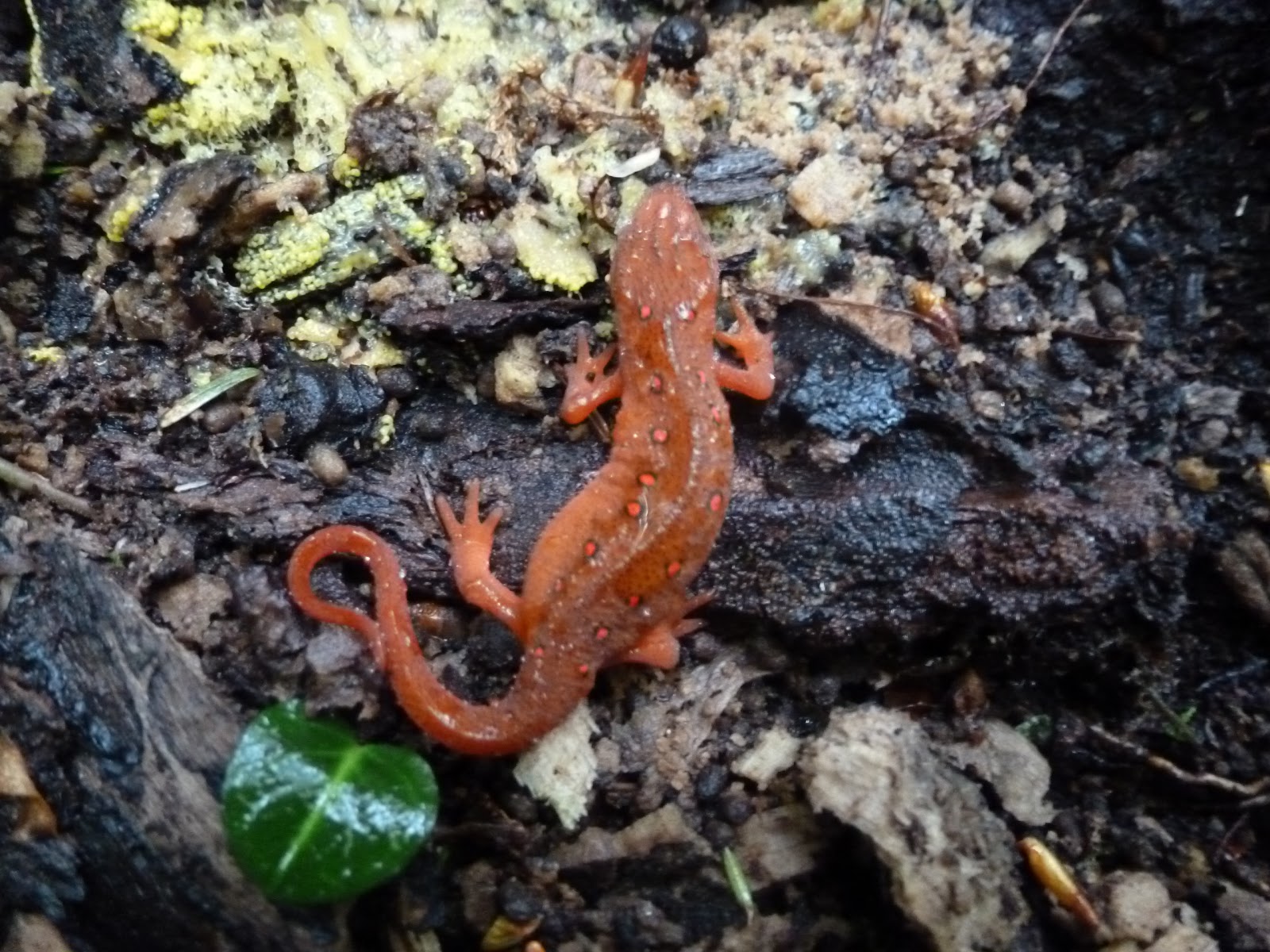
As I walked the tracks I was startled by a large black snake, a racer I believe.
It slithered across the tracks and started to climb the rock-cut to the side. I left the snake in peace as I continued on.

It was not a very exciting walk on the tracks. I got to the southern terminus of the Laurel River Trail just as a train approached and hit the trail.
I immediately began to see the ruins of the old town of Runion.
Some of the ruins were covered in graffiti.
I poked around among the few remaining structures
and then got back on the main trail to hike to the point where we had turned around the last time we had hiked here. It didn't take long to get to the fallen, poison ivy covered branch that blocked the trail, and so I turned around for the hike back to the railroad tracks and my car. On the way out I ran into a group of teens, beer in hand, ready to party at the swimming hole. I just hope they stay safe and clean up after themselves.

Monday, May 20, 2013

Photos of the Day: The Milk Snake

We saw this beautiful snake while out walking around our temporary home. It didn’t seem too shy, as it slithered right around my foot before heading into the tall grass.

Sunday, May 19, 2013

Cherokee National Forest: Paint Creek Trail

Today, despite the light rain and threat of more, I headed over to Paint Creek. This time I would not be walking along the road there, but on the Paint Creek Trail. I parked at Moses Turn near the train wheels
and headed over to the campground. I walked through a portion of the campground and hit the trail crossing a deep section of Paint Creek on a footbridge.
The hike started off easy enough on a well-defined trail that was relatively free of brush. As I traveled further along the creek though, the trail got to be more and more overgrown. Still, because the trail basically paralleled the creek it wasn't too difficult to follow.
That is, until I crossed the creek on another foot bridge.
Once I crossed over the trail became impossible to follow. At first I thought about just turning around, but my curiosity got the best of me and I ended up thrashing through the thick brush
and wading through the creek. I just followed what I thought was the best route upstream. Sometimes I was actually able to find the trace of a definite trail, but mostly my route was just a guess.

Along the way I did see some wildflowers in bloom
and even a box turtle.
Eventually I came to a clearing. There was an old, abandoned mobile home and I could hear the sound of traffic on a major roadway.
"Where am I?", I wondered. It didn't take long to figure things out. I was just off the Asheville Highway which is not anywhere near where I had intended to go. Yet I was able to follow the remains of a definite built trail at times. I even saw a few blazes: yellow metal diamonds attached to a few trees.
Anyway at this point, rather than bash through brush for a few miles I opted to follow the Asheville Highway back to Paint Creek and my car. It added a 4+ mile road walk to my hike but it was better than my other option.

Saturday, May 18, 2013

Cherokee National Forest: Squibb Creek Falls

Despite the rain this morning, I felt I had to get outside and go for a hike. I decided to head back to the Horse Creek area and hike in the Sampson Mountain Wilderness where Sierra, Noelle, Parker and I had hiked the tough loop a few days back.

I made the drive to the recreation area, parked at the end of the paved road, and walked a small portion of the road that follows Horse Creek.
It was foggy and the fog and light rain seemed to give an air of somberness to the scene. Soon I crossed Horse Creek on a footbridge
and headed into the wilderness area.
I passed by the strange cabin seemingly located within the wilderness boundary.
I took a quick look inside and it appeared to be a comfortable place to spend a vacation. Then I crossed Squibb Creek which I would follow for the rest of my hike.
There were lots of pretty cascades on the creek
and a few wildflowers made their presence felt.
There were also lots of snails on the trail,
along with some red efts.
The hiking was rather easy. I wish I had planned this hike for when Noelle, Sierra and Parker were with me instead of the slog up Turkeypen Cove. Before I knew it I was at the falls.
The falls were pretty, but I am glad that I made the trek in a time of high water as it appears that the falls are not always flowing with much water. After eating a snack at the falls I retraced my trail back to the car. There were lots of butterflies on the rough road near the parking area.