Sunday, January 30, 2022

Maxwell Natural Area: Hike to the "A"

Today the forecast called for warm temperatures and, better yet, little to no wind! We decided to take advantage by getting out of town and heading down to Fort Collins for some hiking, eating, drinking and playing at the playground. After a pitstop at Sierra Trading Post in Cheyenne, we made it to Fort Collins and drove to the Maxwell Natural Area for our hike on the Foothills and Overlook Trails to the big "A" above the former Hughes Stadium site. 


 Almost immediately, we realized how snowy and muddy the hike would be. Portions of the trail were slippery, packed snow, while other areas were a thick, muddy mess. We stopped to admire the view of our hike's destination. 


So why an "A" you might ask? Colorado State University's mascot, now the Rams, was formerly the Aggies. After a short stop and photo-op, be continued on, gently ascending the muddy path past the stadium site's boundary. 


We passed a few prairie dog towns that really captured Rosie's attention.


Then, we started climbing more steeply up to a ridge.


At the top of the ridge, we passed through a small meadow area with scattered ponderosa pines.


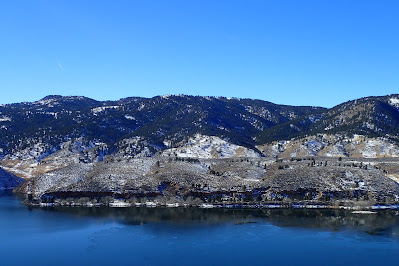
Soon enough we approached the road the parallels the eastern shoreline of Horsetooth Reservoir. Near the road we turned onto the Overlook Trail.


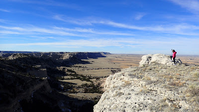
We followed the Overlook Trail up to a rocky ridge overlooking both Fort Collins on the east, and the mountains and reservoir to the west.


We spent some time up there relaxing, enjoying the view and eating some apples. Surprisingly, we had the whole place to ourselves for our entire time up there. Eventually, it was time to head back. We retraced our steps back the way we had come through even messier conditions in the warming temperatures. 


After changing out of our muddy footwear, we drove into town for lunch at the new Sweetwater Brewing. The food was pretty good, especially Sierra's smoked wings! The beer was decent also.


After lunch, we headed to nearby Sugar Beet Park where Sierra played 


and I walked Rosie to the new sculpture.


Our final stop of the day was a drink at Peculiar Brewing's new Fort Collins tasting room. Then, it was the drive back to Gering.

Friday, January 21, 2022

Medicine Bow National Forest: Skiing the Happy Jack Trails

This morning I awoke to a weird slick, slushy, slippery mess. After taking Rosie for her morning walk, I hit the road. I was headed southwest through Cheyenne to the Happy Jack Recreation Area. It was a pretty slick drive down to Kimball. However, Interstate 80 was mostly clear. That is, until I started to climb up the Gangplank west of Cheyenne when blowing snow made the road surface slick. I was relieved to exit the Interstate at the Summit Rest Area where I used the restroom. Then, I made the short drive over to Happy Jack.

I was a bit concerned about the lack of snow for most of the drive. It wasn't until I was within about 5 miles that there seemed to be enough consistent snow coverage for skiing. 


Another shock was the nearly full parking lot. It seems a senior group from Laramie was there for a snowshoe hike. After a few minutes of prep, I hit the trail. I am definitely out of ski shape! 


I ended up skiing the Meadow Trail to Phil's Pholly to the Tie City Loop where I started to make my way back west towards the trailhead. 


On the way back I skied the Ridge and Alder Trails 


back to the campground at the trailhead. It wasn't a particularly long ski, but I am really out of shape and felt like I got a good workout. Really nice job by the Medicine Bow Nordic Association maintaining the trails, though there was not a set classical track. I think this was due to a high school race later in the day. 

Saturday, January 15, 2022

Scotts Bluff National Monument: South Bluff Hike

 First post for 2022! Today, Noelle, Sierra and I did the off-trail hike up South Bluff at Scotts Bluff National Monument. We parked at the visitor center parking lot, crossed Old Oregon Trail Road and then traversed the prairie as we made our way towards the base of South Bluff.


It was a cool morning, but luckily there wasn't much wind to contend with. Soon enough the climb commenced. We used clumps of grasses as steps to ascend the steep slope.


There were lots of great views north to the visitor center and east towards Dome Rock and Gering.


Once we had ascended to the relatively flat top of the bluff, we made our way to various viewpoints. The first viewpoint faced west with views of a distant Laramie Peak, 104 miles away. 


Next, we headed southwest to another viewpoint.


There were impressive splotches of orange lichens growing on the rocks here.


Finally, we made our way over to a southeast facing viewpoint. 


We admired the view here for a bit before making our way to the edge of the summit area for the very steep descent back to the car.