Sunday, April 30, 2023

Scotts Bluff National Monument: Into the Badlands

 Yesterday, I had arranged and led a small group cleanup of the badlands area of Scotts Bluff National Monument. It is a small area of erosional features that contains a wealth of paleontological resources. Despite the windy conditions, we managed to clean up a fairly large portion of the badlands.

Having my interest in the badlands renewed, I decided today would be a good day to do some exploring in that part of the monument with Noelle and Sierra. We made the short drive to the gate, parked off to the side of the road and started our hike on the canal road. We followed the fence marking the eastern boundary of this part of the monument and then started to make our way into the erosional features to explore. 


Where we entered into the badlands, we were practically at the railroad tracks that bisect the northern part of the monument. A look back towards Scotts Bluff offered wonderful views of the bluff itself, and the interesting erosional formations.


As we explored the area near the railroad tracks we found a few areas of fossils. 


Most appeared to be turtles, which are very common in this area. Likely stylemys nebrascensis. I also found pieces of what appeared to be fossilized beaver teeth. 


They had a dark section that appeared to be the iron rich enamel that beaver teeth are known for. 

As we roughly followed the railroad tracks west, we made our way into a small canyon and then climbed a ridge up and then down into a different canyon system. This part of the badlands appears to get much less foot traffic than the section where most people enter at the east end of the canal road. Almost immediately, the scenery seemed a little bit more dramatic.


We found some really large bones. They weren't fossilized, but looked to be from bison or cattle. 


They seemed to be badly weathered, giving the impression that they belonged to an animal that died long ago. We started to make our way up this canyon system, admiring the views along the way.


At one point we saw a mule deer standing on a slope a little way up the canyon.

As it ran from us, the rest of the herd made its way up and out of the canyon. I'm guessing they don't see too many people back here. 

We slowly made our way up the canyon, admiring the scenery and looking for evidence of ancient animal life as we traveled. 


Sierra and I even followed some really narrow, twisting canyons.


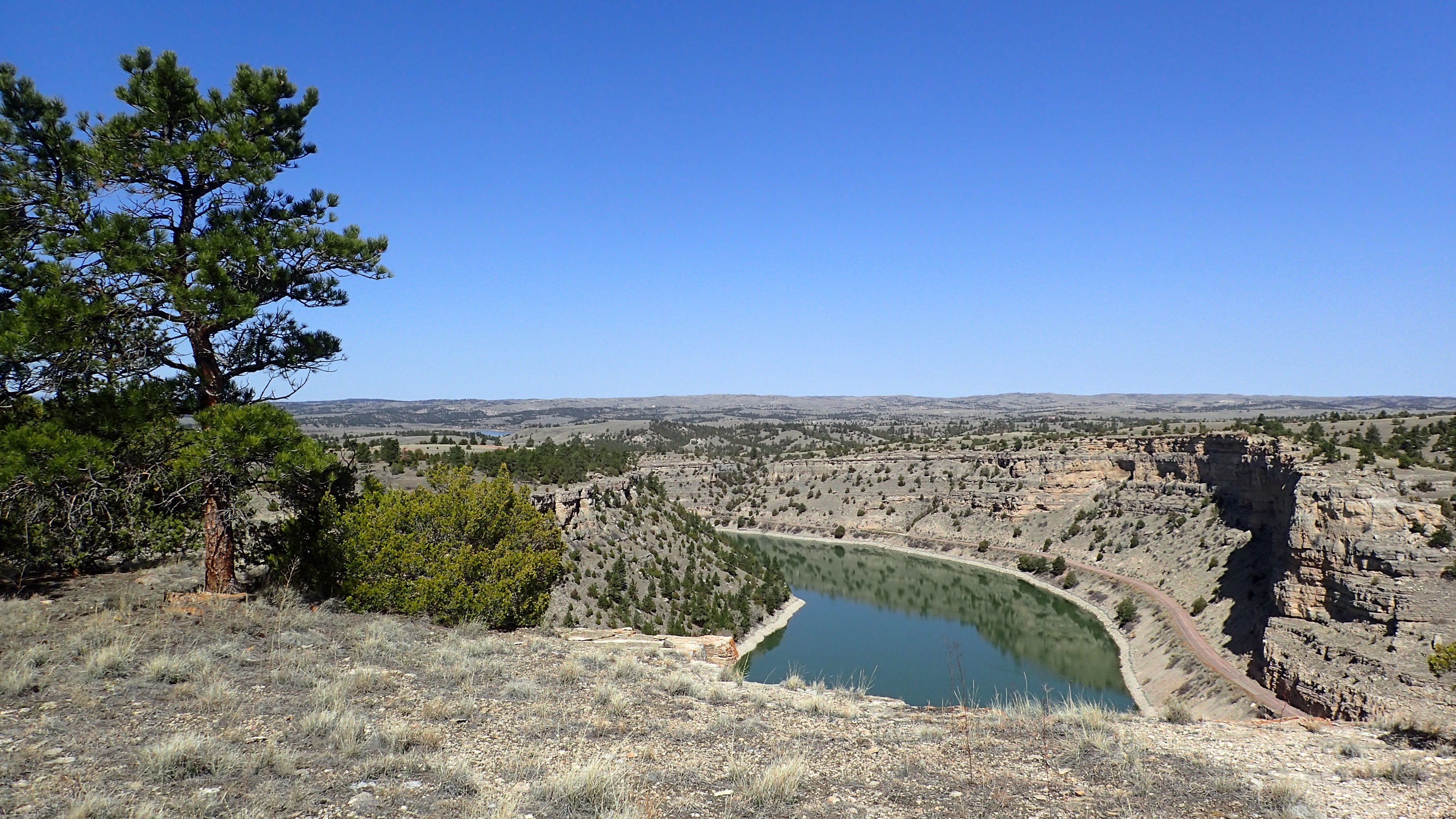
The views were stunning.


Eventually, we made our way up to the canal road and followed it east back towards the car. Along the way, I scared up a wild turkey and we all enjoyed the views looking down into the badlands from which we had just come. 

Sunday, April 23, 2023

Guernsey State Park: Davis Bay and Newell Bay Loop

I had a wonderful time hiking at Guernsey State Park last week and so when Noelle and I decided we wanted to get out to enjoy the nice weather today, I thought it would it would be fun to return and do another hike, this time with Noelle, Sierra and Rosie.

We picked up some sandwiches in Scottsbluff and made our way west to the park. We paid the entrance fee, and then drove to the trailhead at Davis Bay where we ate our sandwiches at one of the campsites. Then, we hit the trail. 


The trail started with a relatively steep climb on a spur to the starts of the Davis Bay Loop. We decided to follow the trail in a clockwise direction. The next section of the hike continued to ascend,

eventually leading to some nice views overlooking the Guernsey Reservoir.


Soon the trail left the edge of the cliffs overlooking the water and headed inland. We crossed the Brimmer Point Road and found ourselves at a neat looking bridge that crosses a small canyon at the start of the short Brimmer Point Trail. 


At this point, I believe the trail becomes the Newell Point Trail. We followed it partway down into a small, interesting canyon.


The trail continued to follow a bench partway down the canyon. Views both downcanyon and upcanyon were pretty interesting.


In some of the warm, south-facing areas the spring's first wildflowers were in bloom: Hood's phlox and violet.


As we exited the canyon, we had views of the reservoir again. This time cabins lined the shore. The trail took a turn towards the west offering lots of great views out towards Laramie Peak. 


As the trail switchbacked east, views opened up across the water.


Soon, our trail approached a cluster of small caves. 


Not surprising, since the rock here is mostly limestone. We explored the caves for a bit 


before continuing on the loop.


The trail ascended to a flat area, crossed the Brimmer Point Road, and then started to descend on some fairly steep switchbacks back towards the car. 


On this homestretch we caught our last views of the reservoir and Laramie Peak.


Sunday, April 16, 2023

Guernsey State Park: Lakeview, Marsh Mountain, North Bluff Trails

 Noelle wasn't feeling well this morning and Sierra was still sleeping, recovering from her sleep over the previous night. I wanted to get out for a hike, since I hadn't been on one in a while. Since I would be going solo, it meant that I go opt for a longer route. I decided to make the drive out to Guernsey State Park and try a hike there. I had read that many of the trails at Guernsey State Park are difficult to follow, but with the AllTrails app on my phone, I figured I would be pretty safe finding my way around. I opted for a 7.5 mile long hike called the "North Bluff Trail" on AllTrails. It's an out-and-back hike. In reality, it actually follows three different trails: the Lakeview, Marsh Mountain and North Bluff Trails.

After getting fuel in Torrington, I made my way through the sleepy towns of Lingle and Fort Laramie before driving through Guernsey, across the North Platte River and into Guernsey State Park. I paid the $12 non-resident day use fee and made my way to the trailhead at Davis Bay. 


I parked and hit the trail, immediately ascending a short, steep hill.

After a short hike I found an old dump site that was littered with rusted tin cans. 


Could this be left over from one of the CCC camps in the park? As I ascended a bit higher, I caught my first view of the Guernsey Reservoir. 


A little further along, I caught my first of many views of the iconic Laramie Peak.


Much of the rock in the park is limestone. Parts of the trails traversed nearly flat limestone shelves that were pock-marked with calcite geodes.


More views of Laramie Peak opened up to the west.


Soon enough, I climbed up to the top of a high cliff overlooking the reservoir below. 


The cliffs, especially the one at Brimmer Point, are impressive and the view reminded me how badly I would like to get the canoe out on the reservoir in the canyon sections of the park.

After hiking the Marsh Mountain Trail, I found myself at the North Bluff Trail.


Again, the views across the lake were pretty spectacular. Soon, I found a sign for a trail that I wasn't expecting: the Echo Cliff Trail.


I decided to take it. The trail descended pretty steeply to a bench about 1/3 of the way down to the water. Soon enough, I found myself at some shallow shelter caves (labeled as Echo Cave) 


with views looking out across the canyon. 


After eating a snack and drinking some water at Echo Cave, I ascended back up to the top of the canyon and soon made my way to the Castle, a fancy picnic shelter built by the CCC.  


Noelle, Sierra and I had visited the Castle last summer when we found the waters of the North Platte River too swift to tube on. I stopped to check out the interesting structure again and also used the restroom in the "Million Dollar Biffy". Then I made my way to the end of the North Bluff Trail before turning around to retrace my way back to the trailhead. There were a few more views out across the lake.


On the way back I viewed a turkey vulture sunning itself on a tree branch,


and saw my first blooming flower of the spring: Hood's phlox!