It's getting to be my favorite time of the year to go hiking in the woods of eastern United States. OK, really it's my favorite time of the year to go hiking anywhere. It's the time of the year when the goldenrods
and the asters start to bloom.
And so with excitement I headed out for a hiking excursion in Shelton Laurel Backcountry Area of Pisgah National Forest. Today I would be hiking a loop on the Fork Ridge, Appalachian and Jerry Miller Trails. I made the drive through Allen Gap and took a detour to Franklin Mountain Road before finding myself at the trailhead, deep in the Carolina woods.
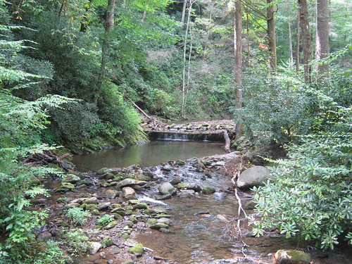
I parked the campsite, trailhead at Jerry Miller. There is a monument to the namesake of the trail there,
along with a nice cold deep swimming hole below some strange type of old mossy dam.
Rather than begin my hike on the Jerry Miller Trail, I opted to hike up the road a bit which paralleled the pretty Big Creek
and veer off into the woods at the Fork Ridge Trail. Hiking the road made for some fast moving and there were lots of wildflowers in bloom.
I got to see some old familiar favorites like sneezeweed and jewelweed. Soon I found a sign marking a trailhead parking area. There were three trails that seemed to start from the trailhead though. I took the trail closest to the small creek that flowed through the area and it quickly dead-ended. Next I tried the one on the far right and it proved to be a good decision.
The Fork Ridge Trail was very well maintained which was quite a relief. I made fast time on the clear trail and gentle ascent of the lower reaches of the trail. As I made my way up the mountain, the trail got quite a bit steeper. Still, it was well maintained though. Eventually I reached the Appalachian Trail. I opted to take a side trip over to the Jerry's Cabin Shelter.
I realized I had last visited this shelter during my thru-hike. It was on April 20th of 2000. It was interesting to be back, but it looked a little more run down than I remember it. There wasn't much of a register there, just a few journal pages that dated back just two days. I signed the register and ate a snack. There were lots of bees buzzing around in the jewelweed surrounding the shelter.
Soon I was joined by two gentlemen out doing a 20 mile hike. I think they were going from Devil Fork Gap to Allen Gap. It would be a long day for them and I did not envy them.
After saying goodbye to the two hikers I hit the trail again. I retraced my steps back to the junction with the Fork Ridge Trail and then continued on the AT. There were lots of flowers in bloom, especially goldenrods, asters, and jewelweed (both spotted and pale). I soon came to the section that goes over Firescald Knob which I had hiked last weekend with Noelle and Sierra. Once over the knob and off the recently relocated section of the AT I found the Jerry Miller Trail and started my descent.
The trail was a bit overgrown in sections but not in bad shape overall. Like many trails in the Appalachians, large portions of the Jerry miller Trail followed old roads.
I made my way slowly down and eventually came to a rock with a circle and cross on it.
I'd like to think it's and ancient Native American pictograph, but it's probably just an old survey mark. Just past the painted rock I left the road on a foot trail. I passed through a wet area
and then eventually descended into some old fields. The fields were overgrown and made the trail difficult to follow. I was able to make my way through the brush and was even treated to a wildflower show.
At this point the trail began to descend steeply along a cascading stream. Forest Service literature states that there is a 100 foot tall waterfall along the trail, but I did not see it. Before I knew it I was back at the trailhead, ready to return home to see Noelle and Sierra.


No comments:
Post a Comment