This hike wasn't supposed to happen. I checked the forecast this morning and it called for a 100% chance of rain. I had resigned myself to a day of chores and lounging. Then, this afternoon as I was sitting at the computer, I saw sunlight filtering through the blinds in the spare bedroom and decided that I would risk the still mostly cloudy skies and head out for a hike. Since it was already late, it would have to be something close to home. A glance at the map revealed an intriguing trail called Phillips Hollow near Margarette Falls. This would be my intended destination.
The sun did not last long and I made the drive to the trailhead in a light drizzle. By the time I hit the trail the rain had pretty much stopped and I walked the road in the public right-of-way without getting wet. I reached the start of the true trail in no time at all
and crossed a creek to begin my hike. The Phillips Hollow Trail followed an old road lined with rocks.
It was easy walking but something about the scenery made the going slow. There was too much to look at to hike fast. One of the first things that attracted my attention was an intriguing rock shelter on the other side of the creek. I crossed the creek near some pretty cascades
and then headed along a cliffline to reach the shelter. There must have been a trail that once led to it, as there were stone steps and wooden pegs that once held log stairs in place.
The shelter was not as interesting as it had looked from a distance
and I spent little time inside it before retracing my steps back to the trail.
Once back on the trail, I again followed an obvious old road and even found a stone foundation of some type. The trail eventually led right into a creek. There was a blue blaze on a rock in the creek,
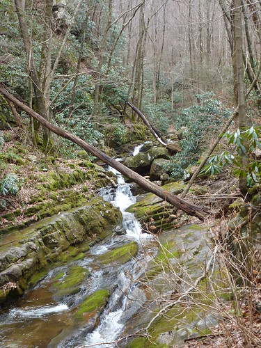
but flagging tape seemed to mark the more obvious trail to the right. I followed what I thought to be the official trail into a wonderland of cascading water!
Every bend on the creek (Dry Creek) brought me to a new section of cascades
or natural waterslides.
While it was too early for blooming wildflowers, I did see a few small snails;
what I believe to be a harbinger of spring. I also found a frog on the trail, but it appeared to be dead.
I continued to follow the trail further and further upstream. The creek held less volume the further up I went, but the cascades still appeared plentiful.
The Phillips Hollow Trail is only supposed to be 1.7 miles long. Certainly I had hiked at least that far. In addition the blue blazes were often faint,
and the trail seemed to vanish for stretches at a time. I began to doubt if I was actually on the Phillips Hollow Trail. The only problem was that this was the only trail in the vicinity marked on my map. It was starting to get late and the trail was getting overgrown and so near this last cascade I decided to turn around and make my way back to the car.
The return hike went quickly. When I arrived at the creek crossing where I found the boulder marked with a blue blaze, I decided to do some investigating. Sure enough, there was another blue blazed trail that continued up stream on the other branch of the creek. This must be the real Phillips Hollow Trail. Now I was curious. What trail had I been following? I finished the hike out to the right-of -way and then back to the car.
When I arrived home I did some research and discovered I had been hiking the Spruce Thicket Trail which had been washed away in large sections and abandoned by the US Forest Service some years ago. Despite its unofficial status, I would highly recommend a trip on this trail, one of my favorites in the Greeneville area.


No comments:
Post a Comment