Sunday, March 16, 2014

Cherokee National Forest: Spruce Thicket Trail

This hike wasn't supposed to happen. I checked the forecast this morning and it called for a 100% chance of rain. I had resigned myself to a day of chores and lounging. Then, this afternoon as I was sitting at the computer, I saw sunlight filtering through the blinds in the spare bedroom and decided that I would risk the still mostly cloudy skies and head out for a hike. Since it was already late, it would have to be something close to home. A glance at the map revealed an intriguing trail called Phillips Hollow near Margarette Falls. This would be my intended destination.

The sun did not last long and I made the drive to the trailhead in a light drizzle. By the time I hit the trail the rain had pretty much stopped and I walked the road in the public right-of-way without getting wet. I reached the start of the true trail in no time at all
and crossed a creek to begin my hike. The Phillips Hollow Trail followed an old road lined with rocks.
It was easy walking but something about the scenery made the going slow. There was too much to look at to hike fast. One of the first things that attracted my attention was an intriguing rock shelter on the other side of the creek. I crossed the creek near some pretty cascades
and then headed along a cliffline to reach the shelter. There must have been a trail that once led to it, as there were stone steps and wooden pegs that once held log stairs in place.
The shelter was not as interesting as it had looked from a distance
and I spent little time inside it before retracing my steps back to the trail.

Once back on the trail, I again followed an obvious old road and even found a stone foundation of some type. The trail eventually led right into a creek. There was a blue blaze on a rock in the creek,
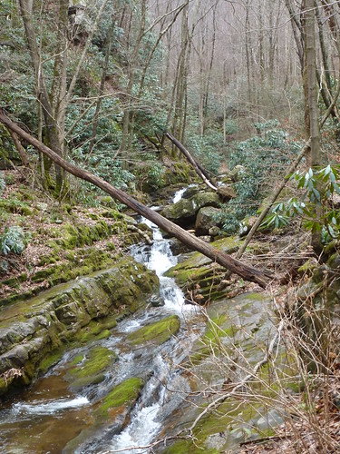
but flagging tape seemed to mark the more obvious trail to the right. I followed what I thought to be the official trail into a wonderland of cascading water!
Every bend on the creek (Dry Creek) brought me to a new section of cascades
or natural waterslides.
waterslide
While it was too early for blooming wildflowers, I did see a few small snails;
what I believe to be a harbinger of spring. I also found a frog on the trail, but it appeared to be dead.

I continued to follow the trail further and further upstream. The creek held less volume the further up I went, but the cascades still appeared plentiful.
The Phillips Hollow Trail is only supposed to be 1.7 miles long. Certainly I had hiked at least that far. In addition the blue blazes were often faint,
and the trail seemed to vanish for stretches at a time. I began to doubt if I was actually on the Phillips Hollow Trail. The only problem was that this was the only trail in the vicinity marked on my map. It was starting to get late and the trail was getting overgrown and so near this last cascade I decided to turn around and make my way back to the car.

The return hike went quickly. When I arrived at the creek crossing where I found the boulder marked with a blue blaze, I decided to do some investigating. Sure enough, there was another blue blazed trail that continued  up stream on the other branch of the creek. This must be the real Phillips Hollow Trail. Now I was curious. What trail had I been following? I finished the hike out to the right-of -way and then back to the car.


When I arrived home I did some research and discovered I had been hiking the Spruce Thicket Trail which had been washed away in large sections and abandoned by the US Forest Service some years ago. Despite its unofficial status, I would highly recommend a trip on this trail, one of my favorites in the Greeneville area.

Saturday, March 15, 2014

Erwin Linear Trail: TN Highway 107 to Bass Ponds

It was just too beautiful a day to sit around the house. We decided to head over to Erwin and check out the paved trail that you can see from Interstate 26: the Erwin Linear Trail. We brought Parker along for this hike and parked in the lot near the new Pal's Restaurant. Once on the trail we headed south towards the Chestoa Recreation Area.

Even though the trail closely parallels the interstate, walking it was a pleasant experience. It passes by
and crosses over several small streams and ponds.
In the ponds we caught glimpses of turtles, geese and ducks.
There are some really interesting mosaic benches placed along the trail for taking breaks.
Spring made her presence known also: there were some daffodils in bloom along the trail.
The trail also passes a pleasant playground which we stopped at for a short break that allowed Sierra to ride the swing. Altogether we walked just about 1.5 miles into an industrial area where we turned around and headed back to the car. We even let Sierra out of the stroller a bit to stretch her legs!
walking trail threesome

Saturday, March 8, 2014

Appalachian Trail: Laurel Fork Falls from Dennis Cove Road

Today Noelle, Sierra, and I met my friend Burke and his family in Johnson City for lunch and then drove to Dennis Cove to hike a short section of the Appalachian Trail to Laurel Fork Falls. We could not have asked for better weather.

Due to the exceedingly pleasant weather, we shared the trail with lots of other hikes. The trail started out as an easy walk on an old railroad bed. We quickly crossed into the Pond Mountain Wilderness
and then passed through an impressively deep railroad cut.
The trail detoured down
and then back up a section where the railroad had once passed over a trestle. Then we were on mostly level ground for a bit. Eventually the AT left the railroad bed and made a fairly steep descent down to the Laurel Fork and the impressive Laurel Fork Falls.
I had been here before, nearly 14 years ago when I thru-hiked. However, time has served to fade my memories of this place as it looked a bit different than I had recalled. We had Burke take a family photo for us
and Sierra threw a few rocks into the water. Then we headed back up the steep stone steps to the old Railroad bed.

At the railroad bed we stopped to take a short break
and then it was a quick, easy walk back to the vehicles. We bid farewell to our friends and then made the drive back to Greeneville. It was a great day of hiking though, even if it was a short hike.

Saturday, March 1, 2014

Great Smoky Mountains National Park: Old Settlers Trail Greenbrier to Campsite 33

I went back to Great Smoky Mountains National Park today to finish what I had started two weeks ago; namely my hike of the Old Settlers Trail. This time I would head into the Greenbrier section of the park. It was a part of the national park I had never been to before. I turned off of US highway 321 and entered into a pleasant landscape of trees and cascading water. Slowly I made my way to the small parking area at the trailhead for the Old Settlers Trail near a bridge that crosses over the Little Pigeon River.
I grabbed my pack and trekking pole and hit the trail.

The trail started off in a river bottom area with a few interesting rock outcroppings. The trail ascended, then turned away from the river on an old road. I followed the old road for a short distance until I found an unmarked trail leading off through a low area that looked like it occasionally floods. The well-trodden, though unofficial trail then followed an old road up a hill to an old cemetery.
Several of the graves in the cemetery were unmarked, other bore the name Parton.
These were likely ancestors of the well-known entertainer Dolly Parton. I spent a few minutes exploring the cemetery and then headed back to the Old Settlers Trail.

Once back on the trail I followed old roads quite often. While this part of the Old Settlers Trail did not seem to have as many vestiges of habitation as the other section I had hiked, there were some rock walls lining some of the old roads I followed.
Eventually I ascended, following a cascading creek.
Then I started a descent passing the remains of a chimney.
I followed an old road down along another creek and found a well-trodden path which followed an old road on the other side of the stream. I just had to see what the path led to. I followed this old road up a hill to a fairly large cleared area. A well-maintained gravel road intersected my trail at this point. I could see a set of stairs leading up a small incline and so I went to see what was there. It turned out to be another cemetery, my second of the day.
The predominant name found in this cemetery was Huskey.
I took a few minutes to explore the graves a bit
and then ate a snack on the stairs.

After I had finished my snack I hit the trail again. I followed the old road back to the Old Settlers Trail. The trail led through some old fields, now returning to forest. Soon I found a hand painted sign and a blazed trail (not authorized by the NPS I'm sure) that led up to the Green Cemetery.
It was a steep climb up to the cemetery which turned out to be quite small. I photographed one headstone
and then retraced my steps back to the official trail.

The trail led to an intersection with another old road. I was curious and so I followed the road to an unofficial, but well maintained trail. Not knowing where this trail led I returned to the official Old Settlers Trail. This half of the trail definitely did not offer as many glimpses of old chimneys as the other half. I did find an old wash basin,
now rusting into oblivion and shortly before arriving at Campsite 33 I found the most intact section of chimney that I discovered on the hike.
Once I reached the campsite I turned around and had a relatively quick hike back to my car.

Wednesday, February 26, 2014

Natural Chimneys Regional Park

To break up my long drive back to Greeneville, I decided to stop at a place I had seen pictures of in a book long ago, and had always thought looked impressive. I made a slight detour off of Interstate-81 and headed over to the Natural Chimneys Regional Park. I parked my car at the gravel parking lot near the chimneys and walked around and read the interpretive panels about the geologic attraction.
The chimneys are formed in limestone and did not get weathered away like the surrounding limestone due to a cap of resistant chert.

Besides the chimneys, there are some interesting tunnels and caves formed in this limestone.
I went into one of the caves that had not been blocked off.
Since I did not have a light I did not go far though. From the cave I found a trail that led up to an observation point near the tops of the chimneys.
There was a nice view of the tops of the formations and the distant mountains. The quarter mile walk was a nice diversion and when I returned to my car I was ready to make the rest of the drive back to Greeneville.