It's hard to believe that we've been in eastern Tennessee for over 10 months now, and still have not visited Great Smoky Mountains National Park. Today I put an end to our absence at America's most popular national park. Sierra woke up at 4:40 this morning and I could not get back to sleep. Instead I grabbed the pack I had packed last night and got in the car for the drive north on US 321 to Gatlinburg and into the Smokies.
Once I entered the park, the drive up to Newfound Gap was beautiful. The lower elevations offering views of cascading streams and winter's bare trees. The upper elevations offered long reaching mountain views and frost encrusted trees. I parked at Newfound Gap, used the restroom and then hit the Applachian Trail headed north,
my first time on this section of the AT in nearly 14 years.
While the sky was mostly overcast, the cloud deck on the Tennessee side was high. On the North Carolina side, however, I was above a the clouds which made for some interesting views.
The sun even came out for a short time illuminating the frosty trail.
Luckily I had brought my microspikes for the hike. I would certainly need them. I hiked nearly a mile without them, but decided to put them on when I reached a really icy section of trail.
I would be leaving them on for most of the rest of the hike. I continued to follow the icy Appalachian Trail for about 2.7 miles and the intersection with the Boulevard Trail.
Here I made a left turn and soon a right to follow the trail that leads up to the Jumpoff and, more importantly, the summit of Mount Kephart. Mount Kephart is one of the South Beyond 6,000 peaks and so a major destination for peak baggers like me. I bypassed the summit of Kephart at first and headed over to the Jumpoff to check out the view. It was a stunning one.
The trees were frost covered
while clouds clung to one side of the peaks, seemingly held in place by an invisible wall. After enjoying the view for a short time I headed back towards the summit of Kephart for the obligatory summit photo.
Then it back to the Boulevard Trail for the traverse over to Mount LeConte.
I was a bit worried about the Boulevard Trail as I had read that there was lot of ups and downs. This turned out to be untrue. It was a pretty good descent from Kephart,
but then it was pretty much a long gentle ascent to Mount LeConte. The trail offered a few good overlooks of the surrounding mountain scenery,
but as I ascended higher and higher as I approached the summit, I was enveloped by clouds. Still, it was enjoyable walking amongst the healthy stands of spruces and firs.
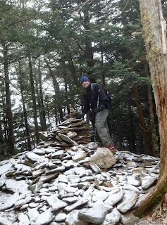
Before I knew it I was at the summit cairn for Mount LeConte. It seemed smaller than I had remembered it from my last time there. I took a photo at the cairn
and then continued on to the Mount LeConte Shelter to eat lunch.
It was a cold, foggy, windy lunch spot. I ate quickly, but still got quite chilled.
I had to get moving again. The descent went well, though going downhill on the ice,
I had to be more cautious than on the ascent. There was an interesting section of trail which looked like the scene of a landslide. There was little vegetation and lots of exposed rock. A cable had been set into the rock to use as a handhold. With the ice, I took advantage of the cable.
I made it back to the Applachian Trail with no problem. The going on the AT was mostly downhill and went pretty quick. I did see something I had missed on the way up. It was an animal trap of some type.
I wonder if it is used to trap the feral hogs that have become such a problem in the southern Appalachians? After inspecting the animal trap, I started moving again back to Newfound Gap. The microspikes were starting to hurt the bottoms of my feet a bit, and so I took them off. Taking them off was a mistake though, as there were still a few very icy sections left to traverse. Eventually I ended up putting them back on until I only about about .5 mile left. The last half-mile was ice-free, but muddy and I made it back to the car in no time at all. I was tired and sore, but it felt good to get another peak under my belt. It was about a 16 mile hike and one of the more interesting hikes I've done since we've been in Tennessee.


2 comments:
Wow, that cloud deck was really cool. Pictures were awesome too.
Very nice. One of my favorite areas. I've hiked there a few times including once from Newfound, over Leconte, and down the Alum Cave trail with the Chattanooga Hiking Club. I was sore for over a week. Some of the best hiking in the Southeast though.
Post a Comment