
Saturday, October 26, 2013
Saturday, October 19, 2013
Blue Ridge Parkway: Craggy Pinnacle
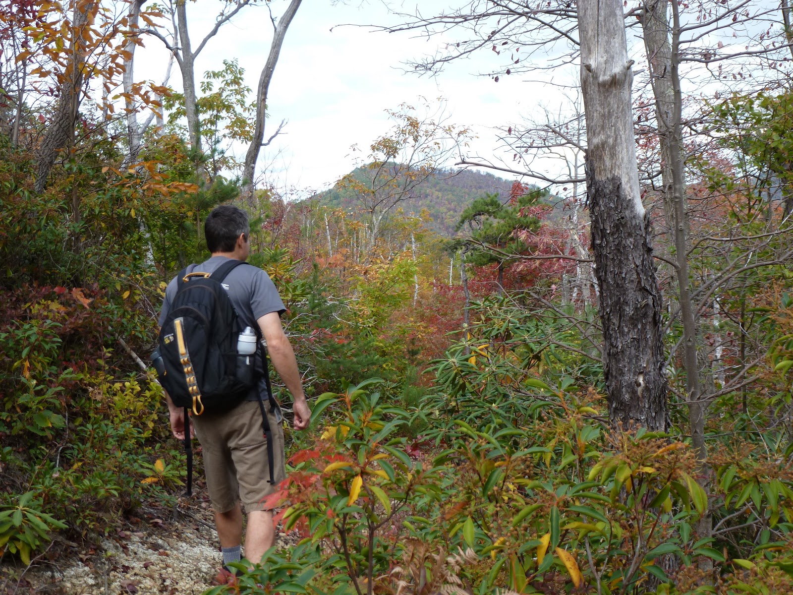
We had a great day today. Headed out for some hiking and fun in North Carolina. We stopped in Weaverville for lunch at Blue Mountain Pizza and Brewery. Then we headed up to the Blue Ridge Parkway. We drove over to the Craggy Gardens area where we had hiked a few weeks ago.
 This time, however, we made the pleasant, short hike up to Craggy Pinnacle. It was a little bit chilly today and a bit overcast.
 Still the fall colors were quite brilliant at around 5,000 feet in elevation.

We hit the trail and started our ascent through a bunch of gnarly looking old, twisted trees.
 We soon got our first views from the Lower Overlook.
 We spent a few minutes there relaxing and enjoying the view before we started to ascend to the Summit Overlook. There we got great views in all directions and could see back to the area we had hiked to a few weeks ago. It was a bit windy up there and so we didn't spend too much time gawking.
 We turned around and made our descent. We stopped at an unofficial overlook on the way down and enjoyed the view from there before returning to the car in a light drizzle.

We took the parkway to the Folk Art Center where we browsed the wonderful art and Sierra did some walking around in the crunchy, fallen leaves. From there we headed into Asheville to get a beer at Green Man Brewing. A great day!


We hit the trail and started our ascent through a bunch of gnarly looking old, twisted trees.


We took the parkway to the Folk Art Center where we browsed the wonderful art and Sierra did some walking around in the crunchy, fallen leaves. From there we headed into Asheville to get a beer at Green Man Brewing. A great day!
Thursday, October 17, 2013

Tuesday, October 15, 2013
Cherokee National Forest: Little Jennings Creek, Cowbell Hollow, Jennings Creek Loop
I figured that the hike today was nothing special, just an excuse to get outside and do some walking. I was partly right, but this hike turned out to be better than anticipated. I made the drive over to Horse Creek and turned off towards Old Forge. I didn't get very far though because the road up to Old Forge was closed. I decided to walk the road to the recreation area and start my hike anyway.

The road walk ended up being much longer than I had anticipated. It was probably about 1.5 or 2 miles from where I parked to the Old Forge Campground
 that had been closed due to the government shutdown. The campground appears to be pretty nice though. Jennings Creek runs right through it and features a really nice deep swimming hole.
 Just above the swimming hole is a small waterfall whose plunge pool makes for another nice swimming spot.
 Past the swimming holes I followed the trail along the creek to the Little Jennings Creek Trail.
The Little Jennings Creek Trail followed its namesake creek for about two miles, crossing the water several times. There wasn't a whole lot to see along the trail though, and so my expectations of "a walk in the woods with not much else" were certainly being met. As I approached the upper reaches of the trail the creek turned to just a trickle. When I arrived at the junction with the Cowbell Hollow Trail I decided to take a slight detour over to Round Knob to see just what was there. It turned out Round Knob is a picnic shelter.
 A nice rustic-style shelter that looks like it may have been built by the CCC. There was also a path that led from the shelter to a nice spring. After checking things out for about 2 minutes I retraced my steps back to the trail junction and followed Cowbell Hollow Trail down the mountain.
The Cowbell Hollow Trail had a much different vibe than the Little Jennings Creek Trail. It was more open.
While the Jennings Creek Trail traversed deep, rhododendron tunneled terrain; Cowbell Hollow looked like it had burned in the past 10 years and so offered some nice views of the surrounding landscape.

 The colors of the leaves in the higher elevations are starting to look really nice!


 I stopped to take lots of photos of the beautiful scenery and eventually found myself on the Jennings Creek Trail.


The Jennings Creek Trail was somewhat similar to the Little Jennings Creek Trail, but because the creek was flowing with more water the views turned out to be more interesting than on the Little Jennings Creek Trail. There were a few nice cascades
 with deep swimming holes at the bottom. Before I knew it I was back to Old Forge and from there the long, monotonous road walk back to the car.
 This wasn't the most exciting hike I've ever been on, but it did exceed my expectations.

The road walk ended up being much longer than I had anticipated. It was probably about 1.5 or 2 miles from where I parked to the Old Forge Campground


The Little Jennings Creek Trail followed its namesake creek for about two miles, crossing the water several times. There wasn't a whole lot to see along the trail though, and so my expectations of "a walk in the woods with not much else" were certainly being met. As I approached the upper reaches of the trail the creek turned to just a trickle. When I arrived at the junction with the Cowbell Hollow Trail I decided to take a slight detour over to Round Knob to see just what was there. It turned out Round Knob is a picnic shelter.

The Cowbell Hollow Trail had a much different vibe than the Little Jennings Creek Trail. It was more open.
While the Jennings Creek Trail traversed deep, rhododendron tunneled terrain; Cowbell Hollow looked like it had burned in the past 10 years and so offered some nice views of the surrounding landscape.


The Jennings Creek Trail was somewhat similar to the Little Jennings Creek Trail, but because the creek was flowing with more water the views turned out to be more interesting than on the Little Jennings Creek Trail. There were a few nice cascades


Friday, October 11, 2013
Lost Cove, North Carolina Ghost Town
Just a few days ago I was doing something on the the internet when I came across a website that stated there is a ghost town not too far from where I live in Tennessee. The ghost town is called Lost Cove and it is just across the border in North Carolina, not far from Erwin. From what I had read about the place it sounded interesting, but that it was in danger of not existing soon due to thoughtless vandals. I decided I needed to get there before it was gone.
Noelle gave me permission to go on a solo adventure and so I packed my pack and hit the road towards Erwin. I drove through town to near the Chestoa Picnic Area, but instead of visiting Chestoa I crossed the Nolichucky River, passed by Uncle Johnny's (a hostel I visited when thru-hiking the Appalachian Trail in 2000), and drove through the dying town of Unaka Springs. After passing through town I parked near the Unaka Springs Cemetery. I followed an old road from the cemetery down to the railroad tracks.
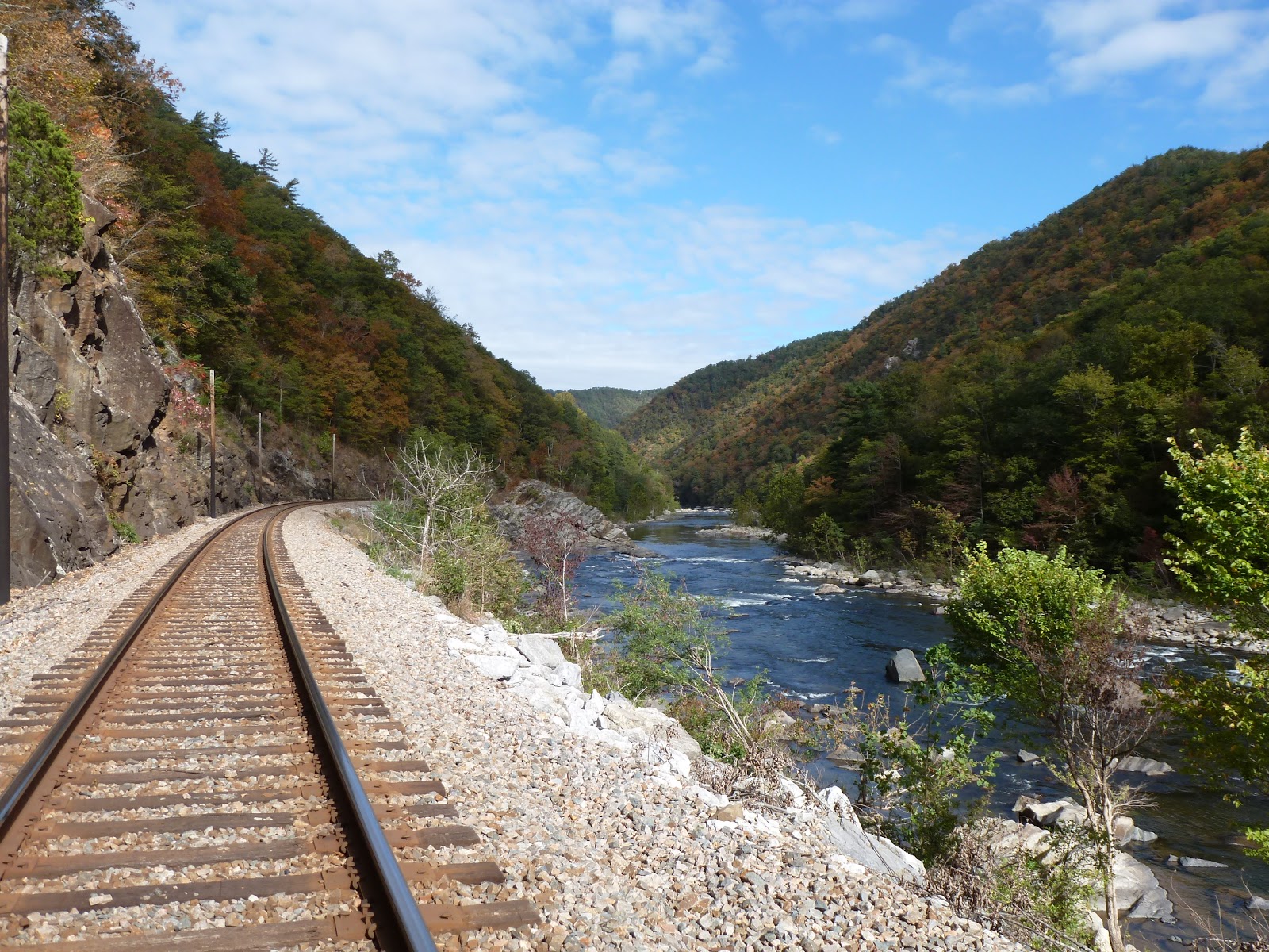
 The tracks would be my trail for this adventure.

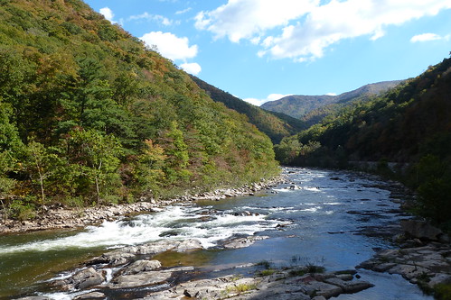
The railroad tracks that run parallel to the Nolichucky River traverse some of the most beautiful terrain in the eastern United States.
 The gorge is deep, the river swift, and the changing fall colors added to the ambiance of this hike. I saw just one train while walking the tracks.
 Luckily I had detoured down to the river when it passed,
 so it was not a problem. You could run into some problems walking the tracks if you happen to encounter a train while on one of the narrow sections of rail bed, but this did not happen to me. There were lots of great views from the rails and before I knew it I was at a graffiti-covered bridge crossing a substantial creek.
 Could this be the route into Lost Cove? Sure enough there was a user trail alongside the creek. I followed this trail passing some beautiful cascades.

 The trail eventually dead ended at a really pretty double waterfall.
 I admired the view here and ate a snack, but I was not convinced that this was the way into Lost Cove. It turns out the creek is called Devil's Creek and so, not being able to find any documentation about the falls on the internet, I will call the falls Devil's Creek Falls.
I backtracked on the user trail back to the railroad tracks and made my way further east. Soon enough I found another small creek with another trail running along side it. This looked quite promising. There was a well-used campsite on a bench above the tracks and an old rocky, washed-out road leading uphill. This had to be the road that leads to Lost Cove! I followed this road up higher and higher. At first there was no sign of any abandoned human habitation. Eventually though, I found a rusted frame of some sort and and a rusted loop of barbed wire.
 This, along with this yellow sign posted to a tree,
 confirmed that I was on the right track.
A little way past the barbed wire the road flattened out a bit. I passed a large rock formation just to the side of the road,
 turned the corner and found the first structure of Lost Cove. It was an old log corn crib.
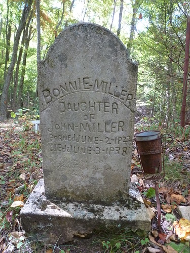
 It was filled with garbage, but still interesting. A trail led past the side of the corn crib and I followed it to the site of one of the two Lost Cove cemeteries. There were a lot of Tiptons buried here, so I'm guessing it is the Tipton family cemetery.
 I spent a few minuted exploring the old, fenced-in cemetery
 before heading back down to the town site. From the corn crib I followed the old overgrown road to the site of an old rusting truck. A photo of the site taken in 1969.
 Nearby was the first chimney I found.
 Things were starting to get interesting! A photo of the site taken in the 1960s.
From the chimney I followed the road further into Lost Cove. A side trail led to the right and I followed it to the remains of a cabin. There was not much left of it, just some burned timbers, a chimney,
 and pieces of the metal roof. This must be one of the two structures recently burned by some teenage vandals. Sure enough I even found the fuel that the low-lifes had used to start the blaze.
 This illustrates the reason I wanted to get up here. I fear in a few years the rest of the buildings up here will succumb to the same fate.
From the burned building I made my way deeper into Lost Cove. I passed some of the rotting detritus left over from years of human habitation


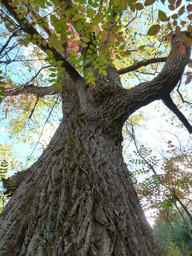
 and also passed one of the largest tulip poplars I have ever seen.
 Then I walked along an old rock wall
 that I had seen someone had posted some pictures of from 1969 on Flickr. Yes, the area has changed a bit in 50 years. From here the road headed over to the largest structure still standing in Lost Cove.
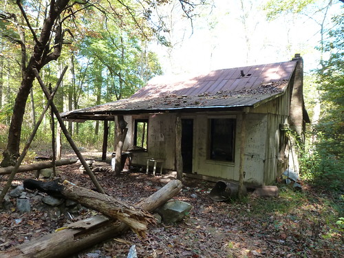
 It's an old house, now covered with graffiti and slowly deteriorating into nothing.
 As I approached I thought I heard a human voice. It turns out that I was alone though. There was a lot of graffiti on the walls and a lost dog notice stapled to the outside.
 I went inside the rotting structure to check things out a bit and then moved on. The road descended and got less distinct. I thought I was outside of Lost Cove and thought about turning around. Then I saw an old set of stairs.
 Supposedly, these are left from the former school/church that once stood here.
Just past the stairs was another still standing structure.
 It appears to be another house. This one is in very poor shape and I guess it will not be standing anymore in a year or two. I did not risk going inside this structure.

From this leaning house I found a different road that seemed to head uphill, back to the main section of Lost Cove. I passed many of the structures I had explored earlier and made my way to the road that leads back to the railroad tracks. I saw the first of two praying mantises in a field on my way back.
 I started to make my way down, when I saw another road that branched off to the right. At this point I felt that Lost Cove still had some secrets to tell. Would her secrets be revealed if I took this road? I decided to find out. I took this road downhill and sure enough passed old foundations an even found an old chimney being reclaimed by nature.
 The road petered out and after a while I found myself back in Lost Cove proper.
It was now getting late. As much as I wanted to explore more, I knew I needed to head back to the car and home. Regretfully, I made my way down the rough road to the railroad tracks.
 I still feel there are secrets in Lost Cove waiting to reveal themselves. I hope to return some day to explore some more. Perhaps winter, when the leaves have fallen off the trees, would be a better time to explore. The fall colors and blue sky were brilliant as I walked the railroad tracks back to the car. I found a big rock alongside the Nolichucky River and climbed out onto it for a fantastic view of some rapids on the low river.
 I also saw the remnants of what appeared to be a train wreck

 and found another praying mantis, this one right on the a railroad tie.
 Then, before I knew it, I was back at the car for the trip back to Greeneville.

Noelle gave me permission to go on a solo adventure and so I packed my pack and hit the road towards Erwin. I drove through town to near the Chestoa Picnic Area, but instead of visiting Chestoa I crossed the Nolichucky River, passed by Uncle Johnny's (a hostel I visited when thru-hiking the Appalachian Trail in 2000), and drove through the dying town of Unaka Springs. After passing through town I parked near the Unaka Springs Cemetery. I followed an old road from the cemetery down to the railroad tracks.


The railroad tracks that run parallel to the Nolichucky River traverse some of the most beautiful terrain in the eastern United States.


I backtracked on the user trail back to the railroad tracks and made my way further east. Soon enough I found another small creek with another trail running along side it. This looked quite promising. There was a well-used campsite on a bench above the tracks and an old rocky, washed-out road leading uphill. This had to be the road that leads to Lost Cove! I followed this road up higher and higher. At first there was no sign of any abandoned human habitation. Eventually though, I found a rusted frame of some sort and and a rusted loop of barbed wire.


A little way past the barbed wire the road flattened out a bit. I passed a large rock formation just to the side of the road,


From the chimney I followed the road further into Lost Cove. A side trail led to the right and I followed it to the remains of a cabin. There was not much left of it, just some burned timbers, a chimney,


From the burned building I made my way deeper into Lost Cove. I passed some of the rotting detritus left over from years of human habitation


Just past the stairs was another still standing structure.


From this leaning house I found a different road that seemed to head uphill, back to the main section of Lost Cove. I passed many of the structures I had explored earlier and made my way to the road that leads back to the railroad tracks. I saw the first of two praying mantises in a field on my way back.


It was now getting late. As much as I wanted to explore more, I knew I needed to head back to the car and home. Regretfully, I made my way down the rough road to the railroad tracks.


Update of August 22, 2015:
Highland Brewing Company out of Asheville has released a summer seasonal ale: Lost Cove American Pale Ale. It is a low ABV session ale and is named in honor of the Lost Cove ghost town.
Subscribe to:
Posts (Atom)