The interesting thing about the sides of the canyons is that there are many cave-like cracks in them in which can be found many petroglyphs. A little while back, when I knew I would be returning to Wind Cave to work for the summer, I decided to search the internet for information about the Cave Hills. What I was able to learn about them was that they are part of the Sioux Ranger District of Custer National Forest,

I woke up early this morning and packed up the car for my last South Dakota road trip. I was on the road by 7:30 headed north into Rapid City to get some food and run a few quick errands. From there I headed northwest into Belle Fourche where I made a quick stop at the new and improved Geographic Center of the United States. After a photo opportunity there I pointed the car north to Buffalo, South Dakota where I would access the Cave Hills. Right off the bat, I was impressed with the scenery.
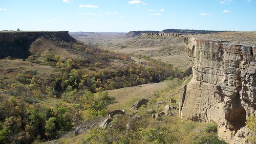
I drove a gravel road into the interior of the Cave Hills up to Riley Pass. Shortly after parking at the pass I parked the car on the side of the road to begin a hike into the unknown. I would be searching for Ludlow’s Cave. While I wasn’t sure of the exact location of the site, there was one spot on my map marked as a cave, and I decided that would be my destination for the day. Almost immediately I found one of the “caves” of the Cave Hills, a small sandstone rock shelter.


After following some ridge top roads for a while, I came to a muddy stock pond swarming with cows. I dropped down into a nearby canyon and found an interesting but small sandstone arch.
 I followed this cliff line for a while and when I started to see quite a bit of graffiti (unfortunately) I knew I was getting close to Ludlow’s Cave. As I turned a corner there it was, just like I had seen in the photos on the internet. There was a large deeply incised petroglyph of a bison cow and calf
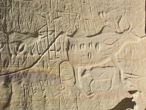
 A closer inspection revealed a warrior with a shield, elk tracks,

I spent a few minutes quietly contemplating the scene before me, before making my way back to my car.
Along the way I inspected some other cliff lines and found a few more faint petroglyphs pecked into the rock.

5 comments:
Do you recall where the cave was located? Tried North of Riley Pass and found nothing, then walked the top South of the Pass and didn't find it- any clues you have would help! Thanks!
Andrew
It's been a long time since I was there. However I recall that I bought Sioux Ranger District of Custer National Forest map and the cave was marked right on it as an upside down Y.
Thanks! I did end up finding the cave, it was in the North Cave Hills, in the SE corner of the park. About a two mile hike east and 1/2 mile North when entering from the South on Cave Hills Road and the cave opens to the NW (for anyone else looking for it). Unfortunately, many of the great pictoglyphs you photographed have been covered by a cave-in near the cave's entrance.
Andrew
Thanks for the information regarding Cave Hills. We live in Rapid and might check it out.
The cave is south east of Riley pass....about three miles
Post a Comment