Monday, June 29, 2015

Tweetsie Trail: Alabama Street in Johnson City to Holly Lane in Elizabethton

I started my furlough today, and decided to head up to Johnson City to ride the existing portion of the Tweetsie Trail. I say existing, because soon the trail will be extended further into Elizabethton. I drove up past Howard Johnson Field, where just a few nights ago I watched the Johnson City Cardinals play some baseball and parked at the start of the trail at the junction of Legion and Alabama Streets.

I got the bike out of the car and hit the trail. Even though the trail runs roughly parallel to US 321, for most of the ride you don't actually see or hear the busy highway. The trail almost immediately enters a rock cut that was blasted out for the Tweetsie (East Tennessee and Western North Carolina) Railroad.

Eventually the trail makes its way to the Milligan Depot
which stands near to where there had been a flag stop for students to use to get to Milligan College.
Just beyond the depot is an interesting water-filled rock quarry
and seating area.

After the rock quarry, the trail gets into the outskirts of Elizabethton, passing some baseball fields. Once the trail enters Elizabethton, it gets less interesting. It passes strip malls and chain stores and restaurants. There are also lots of road crossings to deal with. The trail comes to an abrupt end at Holly Lane.
At this point I turned around and retraced the trail back into Johnson City. The trail does offer some nice views of Buffalo Mountain as you make your way towards Johnson City.
There are no tunnels on this section of trail, but a few interesting bridges to cross.

As I drove back to Greeneville, I noticed construction was progressing on a spur of the Tweetsie Trail that leads into downtown Johnson City. Soon, you will be able to ride the trail to Tupelo Honey Cafe, White Duck Taco Shop, or the Yee-Haw Brewery. The future looks pretty bright for downtown Johnson City!

Thursday, June 25, 2015

Johnson City Cardinals vs. Kingsport Mets at Howard Johnson Field

With Noelle and Sierra out of town to visit with her sister-in-law and nephews who are in the States for a visit from Germany, I thought I would take advantage of my temporary freedom from daddy duties to go to a baseball game. It was the home opener for the Johnson City Cardinals, and so I made the drive up to Howard Johnson Field to see some baseball.

Let me start off by saying that I was not too impressed with Howard Johnson Field. While all the seats are extremely close to the playing field,
the danger of getting hit by a foul ball has been minimized by netting and chain-link fence around the entire playing field. It made for a distracting time trying to follow the action on the playing field as the fence posts were often in my field of view. The quality of baseball was an issue to some extent.
This game was certainly not a pitcher's duel! However, it was fun to see a few homeruns. It was also interesting to sit so close to the Cardinals bullpen.

In the end, the home team lost 10 to 8 to the nearby rival Kingsport Mets. 
I stayed until there was one out in the bottom of the 9th inning, but decided to leave a little bit early to beat the traffic and make the drive back to Greeneville.

Sunday, June 21, 2015

Great Smoky Mountains National Park: Curry Mountain, Meigs Creek Loop

I got a late start hiking today, due to Noelle and Sierra making me a Father's Day breakfast. It was rainbow waffles and bacon. After my delicious meal and a little bit of playing with Sierra I hit the road. it was about 10 am when I left Greeneville. I arrived at the Metcalf Bottoms Picnic Area at 11:45 to start my hike on the Curry Mountain Trail.
The roadside and trailhead area were loaded with day lilies.
The trail started a climb through tunnels of blooming rhododendron.
I watched as an interesting looking insect flew around, and then promptly got caught in a spider web.
I saw some other insects: butterflies
and found a nice looking turkey feather.

After a little more than an hour on the trail I turned onto a section of the Meigs Mountain Trail which I had hiked back in March. I revisited the cemetery I had stopped at 3 months ago,
and then continued on my way on the trail, which was loaded with grape vines.

Soon I found myself at another trail junction. Here I made a right and started a descent on the Meigs Creek Trail. A few wildflowers lined the path,
but mostly the upper section of the trail was lined with ferns.
As I continued the descent I crossed Meigs Creek several times. I found a very large beech tree
and the interesting Meigs Creek Cascades.
Shortly after the cascades the trail began an ascent. I climbed to a dry and somewhat open section of trail and noticed a few fence lizards scurrying across the trail.

Eventually the trail began to descend again. Before I knew it I could hear the sound of auto and motorcycle traffic and rushing water. I was approaching the infamous Sinks swimming hole. There were lots of swimmers taking advantage of the cool water on this hot day.
Sinks 2
Some of the people were jumping off of rocks.
flip off rocks
I wanted to cool off, but the scene at the Sinks was just not me. I headed over to the road and noticed a faint path leading down to the river on the other side of the auto bridge. I made my way down to the river at a series of small cascades
and had the place all to myself. I soaked my feet in the water
and then submerged my entire body to cool myself off for the 2 mile road walk back to the car.

Saturday, June 13, 2015

Great Smoky Mountains National Park: Forney Ridge and Forney Creek Loop

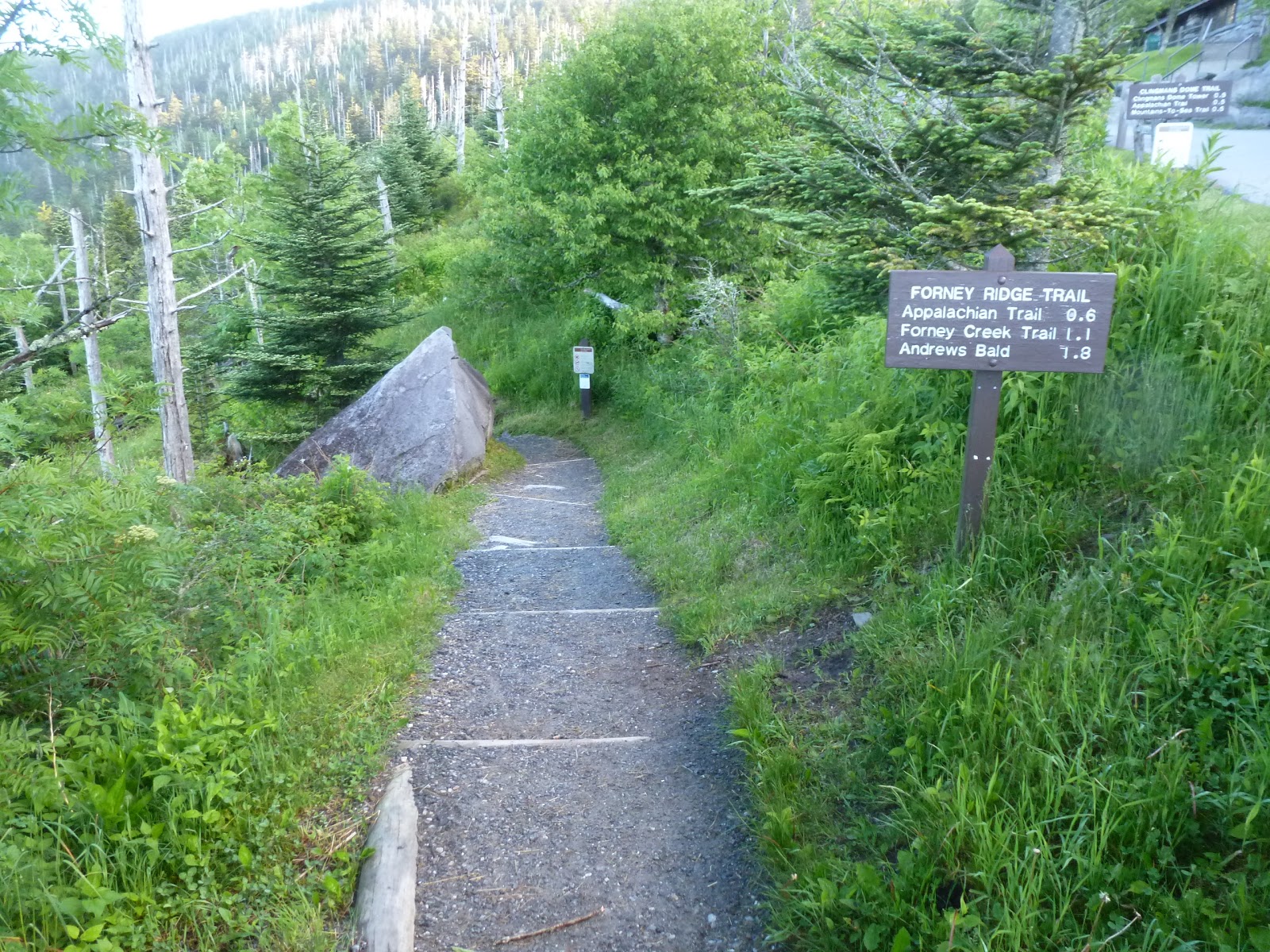
I drove over to Great Smoky Mountains National Park today to add to my hiking mileage total. I drove up to Newfound Gap and over to the Clingmans Dome parking area for the start of my hike on the Forney Ridge and Forney Creek Loop. I started in beautiful morning conditions at the parking area
and quickly hit the trail which started with a pretty steep descent.

The Forney Ridge Trail was very well maintained.
I'm guessing it gets a lot of use from those wanting to make the hike over to Andrews Bald. I hiked on some puncheon
and past a few snails
and soon found myself at Andrews Bald.
The scene at Andrews Bald was pretty nice. There were great views
and lots of flame azalea, some of it in bloom
others not quite ready yet.
Best of all I had it all to myself!

I followed the Forney Ridge Trail past the bald and its condition deteriorated rapidly. The first two miles beyond Andrews Bald the trail was overgrown, rocky, rooty, and often on a steep muddy incline.
There was still lots of flame azalea in bloom.
Besides the azalea, I saw many toads hopping across the trail.
I stopped to admire a large oak tree for a bit,
before continuing on to the Springhouse Branch Trail.

After a short time hiking on the Springhouse Branch Trail, I spotted a nice looking log to sit on and stopped for a snack.
As I was sitting there I had a feeling I was being watched. Sure enough, as I looked around I spotted a toad peeking out from a crack in the wood of the log.
After my snack I continued on descending through azalea and elderberry
to the junction with the Forney Creek Trail. At the trail junction is campsite #71 and the site of an old CCC camp. There were lots of building foundations,
old debris around,
and the remains of a large chimney.

After exploring the site of the CCC camp I continued on ascending the mostly gentle grades of the Forney Creek Trail. It follows an old rail bed most of the way and every now and then I would see evidence of the railroad era, like old rails. I passed some really well done rock work at a switchback on the former rail line
and sometimes followed very close to the trail's namesake Forney Creek.
A few flowers bloomed and decorated the sides of the trail,
but this time of the year is not the best for looking for wildflowers.

After crossing Forney Creek 6 times (and thoroughly soaking my boots in the process) I found myself at a campsite. Campsite #68 is divided into a lower and upper site, separated by .4 mile. I took a snack break at the lower site and then made my way up to the upper one. There were two waterfalls at the upper site.
Actually, they were more like sliding rocks.
There was also evidence of the railroad/logging era. A train wheel
and lots of cable scattered around.
By this part of the hike I was really starting to get tired. It was slow going as I made my way back to the Forney Ridge Trail for the last part of my hike. My slow pace allowed me to really admire the stone trail work that had been done to this upper section of trail.