Saturday, October 26, 2019

Scotts Bluff National Monument: Along the North Platte River

I've been pretty busy lately in my quest to find a home for Noelle, Sierra and myself. I'm currently living in a temporary efficiency apartment that is not nearly big enough for the three of us and all our stuff. Still, I decided I needed to get out for at least a short walk and so this morning I headed over to the section of the monument between the Union Pacific railroad tracks and the North Platte River.

To get to the start of the hike, I drove down Owl Road. I parked at the gate and the monument boundary
and walked in. There are some pretty big cottonwood trees along the river, and some great views of Scotts Bluff.
Soon enough, there was a small bridge crossing a canal. I decided to see what was on the other side. I found a small section of eroded badland formations that looked nice in the early morning sunlight.
As I explored, I found some railroad spikes,
crystals,
and some bones.
One was a large bone eroding out of the hillside.
Maybe a bison bone?

As I approached the train tracks, I was treated to an amazing view of Scotts Bluff!
After admiring the view I headed back across the canal and then walked the rest of the canal road within the monument. It ended at a dam on the North Platte River.
From there I retraced the road, back to my car.

Friday, October 25, 2019

Scotts Bluff National Monument: South Bluff Hike

With a blue sky and warm October temperatures, today seemed like a good day to explore South Bluff in Scotts Bluff National Monument. South Bluff is the one area in the monument where you are allowed to hike up a bluff formation off of a maintained trail. I parked my car at the visitor center parking lot, crossed the Old Oregon Trail, passed Sentinel Rock,
and started to make my way towards and up the steep hillside to the west side of Crown Rock. As I climbed the views of Mitchell Pass got better and better.
When I had finally crested the ridge just below Crown Rock, the views of Dome Rock were amazing.

I made my way west on the bluff to a large flat area. I traversed the prairie there,
  and found my way to a natural overlook that faced towards the south.

I ate a snack at this "south overlook", then made my way across the bluff to another area looking west across the Wildcat Hills.
I admired the view form that spot also,
then started to make my way down off of South Bluff. The views towards Saddle Rock were pretty great.
I even found a marker that marked the location of the Oregon and California Trails.
Then it was a short walk across the road to my car. It was a great way to spend a beautiful fall day.

Saturday, October 19, 2019

Scotts Bluff National Monument: The Badlands

I've started my new job at Scotts Bluff National Monument and am really excited to live and work here in western Nebraska. There's just so much to do in the region and I can't wait for Noelle and Sierra to get out here with me. First things first, I thought today I had a great opportunity to get out and explore a lesser visited part of the monument: the badlands between the canal and the Union Pacific railroad tracks.

I wasn't sure exactly how to get back there and so I drove Country Club Road to the point where it dead-ends at the monument boundary. I didn't see an obvious way to proceed from that point, so I walked Country Club Road to the point where it crosses the canal on a bridge. I turned left onto the canal, and to my surprise, walked past a few homes on a section of canal road that seems to be a public road.
After a short walk, I came to a gate.
I went around the gate and shortly thereafter came to a sign marking the monument boundary.
Immediately, there were great views of the surrounding badlands.
There were also periodic views out towards the bluff.
I continued to walk the canal road west,
stopping every now and then to admire the views.
I saw a few mule deer along the way, but not much else in the way of wildlife. Then, as I made my way towards the western boundary of the monument, I found very large animal tracks, paw prints, in the mud.
At first I thought they might be mountain lion tracks, but I quickly noticed claw marks. I later learned that some one who lives nearby has a Great Dane, and so I think it was the large dog that made them.

I turned around at the monument boundary and started to make my way back to the car under increasing cloud cover. It was an interesting hike and one I am looking forward to do again with Noelle and Sierra.

Wednesday, October 16, 2019

Sioux Falls, South Dakota

Yesterday I drove as far as Sioux Falls, South Dakota.
I got a room in a hotel for the night and then explored the downtown area for a bit
before retiring for the night. This morning I woke up and headed to Falls Park. I had been there before. Noelle and I stopped there on our way home from our Yellowstone wedding trip back in 2007. I walked around the park and admired the views of the falls.
By 9 am I was back on the road for the drive west and then south into my new home of Nebraska!

Tuesday, October 15, 2019

Otto the Otter in Fergus Falls, Minnesota

In just a few minutes I will cross the Red River of the North into North Dakota and say goodbye to a place I love, the state of Minnesota. My last stop, Otto the Otter! A fitting goodbye to the North Star State.

Monday, October 14, 2019

Completion of the International Falls Every Street Project

Well, it's over. My time in living in International Falls is coming to a close. Tomorrow I set out on the road headed southwest through North Dakota, South Dakota and into my new home in Nebraska. Noelle and Sierra will be joining me once the first half of the school year ends in December. Because I am getting ready to leave, I had to ramp up my running efforts in order to complete the Every Streets project. I was able to finish things up today, just in the nick of time. Today I filled in the rest of my map!


For the past few weeks my focus on completing the project has been mostly in the South Falls area. However, I've gotten to see whole swath of town on my runs; both the pleasant parts of town,

and the not-so-photogenic parts.


I've run on lots of paved, asphalt roads
and quite a few dirt or gravel ones also.


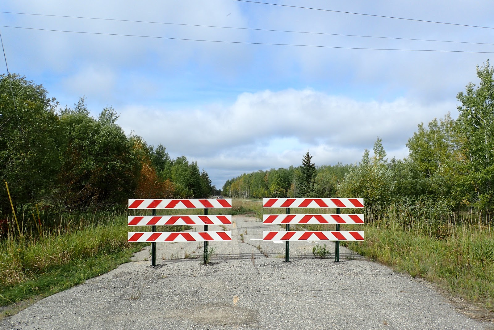
I even ran down roads that ended with little warning.


I ran through neighborhoods, past "normal" homes and also past quirky statues
and murals.

I ran past beautiful, Northwoods scenery, but more often than not, I ran past evidence of a dying lumber town.


Tim Horton's closed after just over a year in business
The closed Holler Elementary School
The soon to be closed K Mart


Perhaps the most interesting area I ran through was the cemetery in town.
Located in a quiet neighborhood on the town's outskirts, it is a fitting final resting place for those who love the quiet and cold of far northern Minnesota.
Among those buried in the cemetery is the town's most famous resident, NFL Hall of Famer Bronko Nagurski.
International Falls isn't perfect, but it was home for 3 and a half years. While I am relieved to be leaving, I know I will miss some aspects of living in "the Falls". The beauty of the lakes and woods, the call of the loons, seeing wolves and snowy owls, and other interesting wildlife, and paddling the waters in Voyageurs National Park all made living up here worth it. We will always take the great memories we made with us for the rest of our lives: seeing a wolf walking across the ice of a frozen Rainy Lake from our living room, Sierra learning to cross country ski, riding our bicycles into Canada.

Goodbye "Icebox of the Nation."