Sunday, December 27, 2015

Cherokee National Forest: Bullen Hollow, Reynolds Ridge Loop

Another day for a hike close to home. My car is not in the best of shape right now and I cannot afford to have it in the shop and so I made the short drive out to the Cherokee National Forest and the trailhead for Margarette Falls. This day would not see me on the Margarette Falls Trail though. Instead I was headed up the Bullen Hollow Trail. I had done some research about this trail and found a loop hike on the Greeneville Hiking Club website
that follows an unofficial trail along Reynolds Ridge, along with Bullen Hollow.

I arrived to an empty parking lot and hit the trail in short sleeves on this incredibly warm December 27th. It was a quick walk on the gravel access road to the the Bullen Hollow Trail where I started my ascent. I huffed and puffed and sweated my way up the trail before it finally leveled off in some open oak woods.
At an interesting little shallow pond
I found a road and turned right. Soon I found myself at the signed forest road 358A
and turned right yet again. After a short walk I was at the junction with the Greene Mountain Trail which I had hiked just a few weeks ago. At a four-way intersection I went straight before quickly veering to the right and descending to the infamous Kennedy Cabin. I had looked for it during my hike of the Greene Mountain Trail, but had no luck in finding it. There's not much left of it, just a few pieces of metal roofing.
There is, however, a piped spring that spills into a set of two barrel halves.
I rested on a rock at the cabin site, ate a snack and found an old Budweiser can.

After my short break I started moving again. After a short but steep ascent, I turned left onto an old woods road and descended through a rhododendron tunnel.
Soon I left the tunnel and followed Reynolds Ridge for a good deal of the rest of the hike. There were a few views out onto the lowlands of Greene County.
There were also some teaberry or wintergreen
wintergreen
growing here and there on the dry ridge. After a steep descent I was back on the Bullen Hollow Trail for the short walk back to the car. Upon returning I found lots of cars parked in the lot. Obviously there are a lot of folks out enjoying this wonderful summer-like weather.

Saturday, December 26, 2015

Photo of the Day: Bays Mountain Falls

It was a ridiculously warm day after Christmas and so the Grunwalds sought to take advantage of the warm weather by going for a hike. We decided to head over to Hawkins County to check out the waterfalls at Laurel Run Park. I figured with all the rain we've had the past 3 days the falls should really be flowing. What I didn't take into consideration was that with all the rain, the trail would be impassable. And so after hiking an extremely muddy trail, we found an un-bridged creek crossing and had to turn around before reaching the falls. We did play on the playground though, and on the way home saw a roadside waterfall we had missed on the way to the park: Bays Mountain Falls.

Sunday, December 13, 2015

Great Smoky Mountains National Park: Trentham Cemetery

I'd noticed this small cemetery a few times while driving past the road that leads to the Sugarlands riding stables. Today I decided to stop to take a look. It is filled with several members of the Trentham family,
and is the site of birthplace of Gladys Trentham Russell.
Gladys Trentham Russell wrote some type of book about the culture of the mountain people in these parts. I found the Andrew Jackson Bradley grave site among the more interesting in the cemetery. There is a stone, I'm guessing his original headstone, that is simply engraved AJ Bradley.
Nearby are two more "professionally" created markers and a Confederate flag.

Great Smoky Mountains National Park: Little Brier Gap and Little Greenbrier Trails

This day's trip did not start out as planned. First, I got a speeding ticket in Pittman Center on my way to the Great Smoky Mountains National Park. Next, I arrived at the trailhead, only to find out one of the trails that I had intended to hike, the Metcalf Bottoms Trail, was closed. I had parked in the Metcalf Bottoms Picnic Area parking lot, crossed the Little River on the auto bridge
and turned onto the trail
when I saw the sign.
My plans for the day had changed.

I headed back to the car and drove to the Little Greenbrier School Access Road only to find that it too was closed. This actually turned out to be better than had the road been opened. I parked in the small lot there and proceeded to walk the road to the Old Greenbrier School. It was a quick walk and when I arrived at the school site, I had it all to myself. First, I checked out the small cemetery.
Then I headed over to the school to have a look around.
It's difficult for me to imagine going to school in a building like this,
but that's just what people did about 90 years ago.

From the school, I headed out on the Little Brier Gap Trail towards the Walkers Sisters Cabin.
It was an easy walk on a gravel road. In 1.1 miles I found myself at the cabin and other outbuildings that belonged to the five sisters who lived here until the last of them, Louisa Susan, died in 1964.

The first building you find is the springhouse.
I peeked inside and found a good, strong flow of water emanating from the ground. Next I walked over to the corn crib.
Finally I went inside the cabin to have a look around.
What I found most interesting was the old advertising print that still clings to the walls in some areas of the inside of the cabin. I found advertisements for Sun Maid Raisins
and trapping equipment.
I climbed up into the loft and then headed back outside for a snack on the porch.
After my snack I found a faint path that led to a big tree just outside the cleared area around the home.
I headed back towards the home, past some yuccas
and back to the Little Brier Gap Trail to continue the climb up to the Little Greenbrier Trail.


Shortly after leaving the Walker Sisters Cabin, the old road which I had been hiking narrowed to a footpath.
I climbed through open forest of scrubby pines to the ridgetop and the Little Greenbrier Trail. At the junction I made a right and continued an ascent up to another junction, this time with the Laurel Falls Trail.
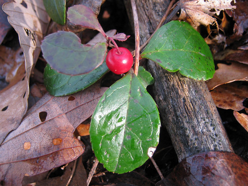
This was my turnaround point. Most of the rest of my hike would be downhill. There's not too much greenery in the plant world this time of the year, other than the obvious conifers. However, I noticed two different species of ferns that still have green fronds and this plant whose name escapes me.

I retraced my steps to the junction with the Little Brier Gap Trail and continued on. The trail mostly followed the ridgeline that serves as the park boundary.
Every now and then a view of Wears Valley opened up through the trees.
The best view was just outside the park boundary, from a wooden viewing platform that had been built near a gap in the trees.
I enjoyed the view from the platform for a few minutes and then continued on. I knew I was close to the trailhead when I saw a family out hiking. The father was carrying his son in a way that no one could do for very long. I reached the road
and made a left to head back to the car.

Sunday, December 6, 2015

Cherokee National Forest: Greene Mountain Trail

It's Christmas Parade day in Greeneville. However, since the parade does not start until 2pm, I had the opportunity to go for a hike close to town today. I opted to hike the 3.7 mile long Greene Mountain Trail in Cherokee National Forest just outside the community of Camp Creek. Perhaps the most interesting aspect of the hike today was the drive up Greene Mountain Road to the trailhead. It's very scenic country back there. I did make a short detour though, as the trailhead on Greene Mountain Road is difficult to find. There is no sign on the road, just a Carsonite post a few yards down the trail from the road.

The hike starts off with a pretty steep climb. The thick leaves littering the trail made for a slippery climb. Every now and then a view opened up through the trees.
Eventually the trail leveled out for a bit
before resuming a steep climb. The trail did eventually level off a bit again and soon enough made its way to an old road. I reached the eastern terminus of the trail after passing through some muddy areas that showed signs of ATV use.
Nearby is a the site of Kennedy Cabin. There are supposedly some stone remnants of the cabin and a spring, but I was unable to find any evidence of the cabin.

I ate a snack and turned around to retrace my steps back to the car.
While it had been cold earlier in the morning, the sun quickly warmed the atmosphere (and created some nice shadows)
and by noon the temperatures had to be in the upper 50s. Unusual weather for December. The return trip, being mostly downhill, went rather quickly and I was back to the car by 12:15.

Saturday, December 5, 2015

The Grunwalds' Family Christmas Tree Adventure 2015

This year's Christmas tree hunting adventure did not go exactly as planned. The Choo Choo Cafe in Erwin, where we had eaten lunch last year, was closed for a private party and so we had to settle for Taco Bell. Oh well. At least the tree hunting itself went well. In fact, things went better at the tree farm than last year. It was much less crowded. It might pay to wait an extra week before looking for the tree in the future.

We arrived at the Frosty Mountain Tree Farm.
Hiked up the muddy/icy road
and quickly found our specimen for the year.
I walked back to the parking are (complete with Santa Horse)
and got the assistance of a sawyer team to cut and haul our tree. We paid, they strapped the tree to the roof of the Subaru and we were on our way home.

We quickly set the tree up at home and even began decorating it.
We're not quite finished with that part yet and so in the future there will be photos of the fully trimmed tree.