Tuesday, September 29, 2009

Exploring Duluth


Today Noelle, Parker and I took some time to explore our new hometown. We went down to the Lakewalk to have a look around. Things at the Lakewalk were looking good. The weather was nice, though cool, and the waves were huge. Parker was infatuated with watching them. We walked away from downtown on the Lakewalk. The trees are starting to change color and everything just felt perfect. I think I'm going to like our new home.


At one point while walking I noticed a sign for the Superior Hiking Trail. A few years ago I remember reading about the trail in Backpacker Magazine. It was rated as the second best long trail in the country. How cool is it that the second best long trail in the United States is right in my back yard? I know I'm going to be spending some time hiking this trail.

Sunday, September 27, 2009

Feeling Minnesota


Today I crossed the North Dakota border into Minnesota, my new home for the next two years at least. It's already cold here. Is this a sign of things to come? I stopped at Bemidji to take a photo of Paul Bunyan and Babe before heading further east to my new little home in Duluth.

The Geographical Center of North America

Last night because of a lack of hotel rooms in Bismark, I slept in my car. Needless to say I was quite tired by the time I arrived home. I did, however, find time to visit the Geographical Center of North America in beautiful Rugby, North Dakota.
Geographic Center of North America

I'm glad to be home and look forward to exploring northeastern Minnesota.

Friday, September 25, 2009

Custer National Forest: Slim Buttes

I felt torn this morning. One part of me wanted to explore some more, while the other part of me knew that I should get back home and get packing and cleaning. Tomorrow is my last day at Wind Cave and I want to get to Noelle as soon as I can. I really miss her. I packed up camp early and got back on the road. I decided I would at least drive through the Slim Buttes unit of Custer National Forest on my way home. Just like the Cave Hills, the Slim Buttes were pretty spectacular, especially the Castles section near Reva Gap. I now have another excuse to come back to South Dakota some day.


I stopped near the gap to take some photos and then stopped again at a historical marker that marked the site of the Battle of Slim Buttes. From there I headed south until I stopped again at Summit Pass. I admired the view there and checked out the poor porcupine who didn’t make it across the road alive. From there I headed further south into Sturgis. In Sturgis I washed and vacuumed my car. I wanted to clean it up a bit before I packed all my stuff into it. I then drove into Rapid City for lunch before heading back to good ol’ Wind Cave National Park.


Thursday, September 24, 2009

Custer National Forest: The Cave Hills

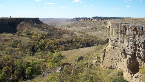
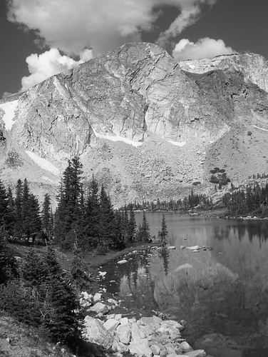
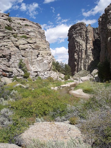
Several years ago on a trip up to Theodore Roosevelt National Park, I can remember driving up US-85 and seeing signs for the Cave Hills. I was intrigued but never had the time to go and see what was there until now. Well, now that I’ve visited I wonder why I took so long in finding my way here. Wow! What a spectacular landscape. While the name Cave Hills might be a bit of a misnomer since there aren’t any true caves and the terrain is not very hilly, the area is definitely worth a visit. A better name might be the Box Canyon Plateaus since the area is a plateau incised by countless sandstone box canyons.

The interesting thing about the sides of the canyons is that there are many cave-like cracks in them in which can be found many petroglyphs. A little while back, when I knew I would be returning to Wind Cave to work for the summer, I decided to search the internet for information about the Cave Hills. What I was able to learn about them was that they are part of the Sioux Ranger District of Custer National Forest,
most of which lies in Montana. I also learned that the hills were home to one of the most significant rock art sites in South Dakota, Ludlow’s Cave. Being a fan of petroglyphs and pictographs, I knew I would have to visit!

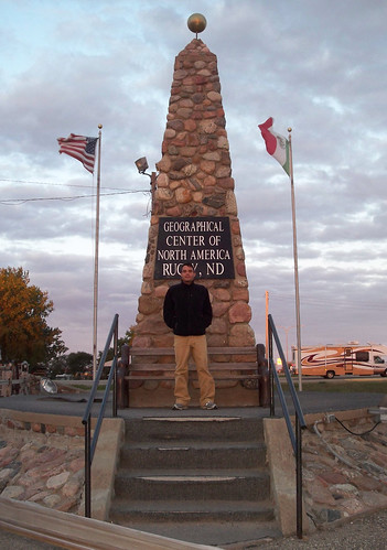
I woke up early this morning and packed up the car for my last South Dakota road trip. I was on the road by 7:30 headed north into Rapid City to get some food and run a few quick errands. From there I headed northwest into Belle Fourche where I made a quick stop at the new and improved Geographic Center of the United States. After a photo opportunity there I pointed the car north to Buffalo, South Dakota where I would access the Cave Hills. Right off the bat, I was impressed with the scenery.
Cave Hills View

I drove a gravel road into the interior of the Cave Hills up to Riley Pass. Shortly after parking at the pass I parked the car on the side of the road to begin a hike into the unknown. I would be searching for Ludlow’s Cave. While I wasn’t sure of the exact location of the site, there was one spot on my map marked as a cave, and I decided that would be my destination for the day. Almost immediately I found one of the “caves” of the Cave Hills, a small sandstone rock shelter.
I would find many more before my day was over. I followed an old road up to the top of the plateau and got some great views of a veritable maze of small sandstone canyons.
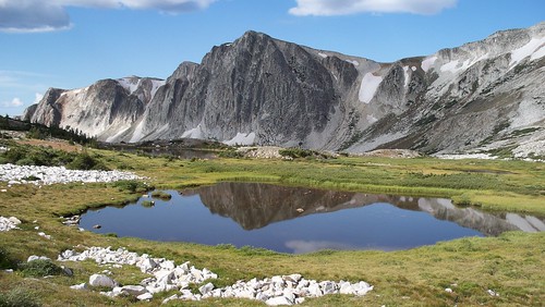
I was impressed. I can’t believe I haven’t heard more about the Cave Hills before.

After following some ridge top roads for a while, I came to a muddy stock pond swarming with cows. I dropped down into a nearby canyon and found an interesting but small sandstone arch.
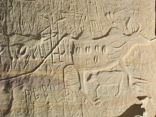
I followed this cliff line for a while and when I started to see quite a bit of graffiti (unfortunately) I knew I was getting close to Ludlow’s Cave. As I turned a corner there it was, just like I had seen in the photos on the internet. There was a large deeply incised petroglyph of a bison cow and calf
Ludlow's Cave Petroglyphs
and carving left by a soldier on the 1874 Custer Black Hills Expedition.
A closer inspection revealed a warrior with a shield, elk tracks,
and an unknown creature pecked into the rock
but somewhat obscured by modern graffiti. It was an amazing site!

I spent a few minutes quietly contemplating the scene before me, before making my way back to my car.
Along the way I inspected some other cliff lines and found a few more faint petroglyphs pecked into the rock.
I was pretty tired by the time I got back to the car. I then headed farther north to the Picnic Springs Campground where I’m camped for the night. I am amazed by this place called the Cave Hills. There is something really special about them and I know I must get back here again some time to explore some more!

Friday, September 18, 2009

Bighorn National Forest: Darton Peak


When I woke up this morning I hadn’t yet decided if I was going to attempt an ascent of Darton Peak or just hike up to the Lost Twin Lakes and enjoy the beautiful alpine scenery. When I arrived at the Lost Twin Lakes in three hours I decided to give the ascent of Darton a try. I had plenty of daylight left and felt pretty good. I soon found myself boulder hopping up a small drainage on the north side of the lakes into the alpine tundra. The walking in the tundra proved to be surprisingly easy and before I knew it I was at an elevation of about 11,000 feet. This was the best I’d felt in the high mountains in quite some time.


Soon I found myself looking down a sheer drop off into a major drainage with no lakes in it. I hadn’t been expecting this canyon, and so I consulted my map to find that Darton was the peak to the left of the canyon. While I wasn’t exactly where I had expected to be, I was still pretty close to the summit. I stopped to eat lunch there and then climbed over around and under some large boulders on the way to the summit. There was a summit register there that I was surprised to find, so I signed it, hung out for a while and then made my way down the summit boulder jumble.


I decided to descend a different route and my decision led me to the head of another deep, glacially- carved canyon. I carefully peered into the canyon and then started down the mountain in earnest. I was back to the established trail in no time and then hiked mostly downhill back to the car. I did not get lost this time. I did, however, find a nice little GPS unit. I didn’t have the conscience to keep it though. I stopped by the Forest Service office in Buffalo to turn it in. I did ask that if it wasn’t claimed if I could have it sent to me. We’ll see what happens. It would be nice to have a GPS for our adventures.

Thursday, September 17, 2009

Bighorn National Forest: Hazleton Peak

As usual the Bighorns did not disappoint today. I headed to an area of the forest I had not been to before, south of the Cloud Peak Wilderness on a seldom used Forest Service road. My destination for the day was Hazleton Peak, a roughly 10,000 foot peak that is not too often ascended. The climb up was pretty straightforward and I easily reached the summit. The return trip, however, was a bit more interesting.


On the descent I decided to take a shortcut and traverse a grassy bowl, cut through a wooded area and return to the old logging road near the bottom of the mountain. I got a bit disoriented on the way down though and was soon lost. I had no idea where I was. I started to feel a little bit nervous. I still had plenty of daylight though and using the sun’s position, I estimated the direction that I needed to follow. My estimate led me to an old logging road and I followed it for a while, paralleling a large meadow. After about a mile of following the road, I decided to take a peek at the meadow to see if there was a road there. To my great surprise the first thing I saw as I looked out onto the meadow was my blue Honda Civic. I guess I wasn’t as lost as I thought I was.

Dry Creek Petrified Tree EE Area

Two weeks ago I ventured into the Snowy Range of Wyoming thinking it would be last time in high mountains for a while. However, with great weather predicted for this weekend I decided to make one last trip into the high country of Wyoming. After work last night I ate dinner and then hit the road with the Bighorns my destination. I made it west of Gillette before calling it a night. I camped at the BLM managed Dry Creek Petrified Tree EE Area. I simply set my sleeping pad and bag on a picnic table and spent the night under the stars.

I awoke this morning excited to see the petrified trees and was not disappointed.
While the petrified wood here was not as spectacular as that at Petrified Forest, Yellowstone, or Theodore Roosevelt National Parks, it was an interesting site nonetheless.
I spent about an hour poking around the area before heading through Buffalo and into the Bighorns.

Friday, September 11, 2009

Black Hills National Forest: Rimrock Trail & Devil's Bathtub

Today I ran some errands in anticipation of my upcoming move to Minnesota. I discontinued my phone service and got a change of address form from the post office. After that I was free to do some exploring. I decided to head up into the northern Black Hills to check out some things I’d been meaning to see. I drove north from Hot Springs through some parts of the national forest I hadn’t seen before and finally stopped when I crossed into Wyoming to see Cement Ridge Fire Lookout. It was a rough drive up there and the lookout was being manned by a forest service fire lookout. It was also very windy and cold up there. I spent a few minutes looking around and then hit the road again headed for Little Spearfish Canyon.


At Little Spearfish Canyon I stopped at the Rimrock Trail trailhead. I wanted to hike the upper section of the Rimrock Trail. The hike was very pleasant. The temperature was much cooler than the previous day and I felt like the hike, temperature, and spruce tree scenery were a preview to my arrival in Duluth. I really enjoyed the easy walk and was a bit disappointed when I arrived aback at my car.


When I got in the car and started up the engine I noticed that my low fuel light was on. I would need to find some gas and find it pretty quickly. I realized that the closest gas was in Cheyenne Junction so I headed up Spearfish Canyon to the little restaurant/gift shop/gas station there. The gas was a bit expensive at $3.00 per gallon, but I didn’t have much choice. I filled up and then headed back down Spearfish Canyon to my final destination of the day: Devil’s Bathtub.

I had never been to Devil’s Bathtub before, but had read about it in an old hiking guide to the Black Hills that I found at the information desk at Wind Cave. Nick, who I had hiked with yesterday, had also mentioned it to me and now my curiosity was piqued. I heard and read there was a sign marking its location, but when I drove through the vicinity where I thought it should be I saw nothing. I drove back to the area again, found a side road that crossed Spearfish Creek where there was another small creek flowing into it, and parked. There was a user trail that paralleled the creek there and I followed it upstream. Sure enough it led to some interesting tight canyons and deep pools that were fed by some interesting natural waterslides. I walked upstream to a sign proclaiming private property and then retraced my steps. It was an interesting hike though and I enjoyed seeing so much water. Had it been as hot as yesterday I would have gone for a swim.


Thursday, September 10, 2009

Black Hills National Forest: Stratosphere Bowl


Today I finally got around to running some errands I’ve been meaning to take care of for a few weeks now. I awoke, did some dishes, ate breakfast, and then took a shower. Then I hit the road headed to Rapid City for a haircut. Before reaching Rapid City I decided to try and find the Stratosphere Bowl Overlook one last time. Noelle and I had been unsuccessful on two previous attempts at finding it. Today was different however. I saw an old, gated Forest Service road on the opposite side of Highway 16 and made a u-turn to check it out. It turned out to be FS 370, which according to my map lead directly to the overlook.

After a short hike on a pleasant, but surprisingly warm morning I found the limestone edge of a large depression. A little further on I saw some wooden railings and finally found the plaque with information about the Stratosphere Bowl. The view from up thee was pretty interesting and I found a few more stone informational panels surrounded by a chain-link fence that told the story of the Stratosphere Bowl and the balloon launches that had happened there in more detail.

From the Stratobowl I headed into Rapid where I ate lunch and got a haircut. From there I moved on to Piedmont where I met Nick for a hike he mentioned and that I’d never heard of before: up Little Elk Creek. The hike was pretty incredible, especially considering I’d never heard of it before. The unofficial trail meandered along Little Elk Creek and made its way through lots of different trees; oaks, ponderosa pines, box elders, elms, and aspens. Perhaps the most interesting part of the hike though was the geology. We walked through a nice limestone canyon with some pockets lined with calcite spar crystal. We turned around at an interesting section of creek where the water cascades over some exposed granite and into some deep little pools. What a great hike, and nice to have someone to hike with.

Friday, September 4, 2009

Medicine Bow National Forest: Medicine Bow Peak

Medicine Bow Peak has to be one of my favorite mountains now! What a beautiful area! I woke up this morning, packed up camp and then headed east into the higher elevations of the Snowy Range. I saw some great wildlife as I drove: three moose and a red-tailed hawk with a small rodent in its talons. Soon I was at Lake Marie and the trailhead for my hike up Medicine Bow Peak. I packed my pack and hit the trail.
It didn’t take long, however, for me to find an amazing view where I had to stop and soak it all in. I decided I would take my time on this hike; there would be no need to hurry. I stopped often to admire the view. I also did something I’ve never done before, I brought my MP3 player and listened to some music on my hike. On the way up the mountain I listened to the Smiths.
Snowy Range Reflection

Snowy Range B&W

Before too long I was on the summit of Medicine Bow Peak.
I ate a snack up there and then headed down. The views just kept getting better! I listened to some of the Killers and Beastie Boys as I descended to some really pretty lakes. What an amazing hike. I had beautiful temperatures and blue skies until the very end of the hike. Towards the end some dark clouds started to roll in, but more than anything else they helped make the scenery look even more interesting.

When I got back to the trailhead, I got into my car and drove east through some more beautiful country. I stopped to check the view at Libby Flats and then started to descend. Soon I was in some desolate country; there wasn’t a tree in sight. Then I made my way into Laramie, home of the University of Wyoming, and a pretty nice town too. I got lunch in town and looked for a little something to send to Noelle in Minnesota. I didn’t spend too much time there though, I had a lot of driving left to get back home.

After leaving Laramie I made a quick stop for a short hike at Vedauwoo, an area of interesting rock formations. From there I went into Cheyenne where I went to Sierra Trading Post to get a cleaner for my waterproof jacket, and then stopped at the post office to mail some things out. Finally I was headed home.

Thursday, September 3, 2009

The Oregon Trail in Eastern Wyoming

Last night after work I ate some dinner and hit the road. My destination was Casper, Wyoming where I would camp for the night and then follow the Oregon Trail west to Muddy Gap Junction. I spent the night under the stars at the beautiful BLM managed Canyon Rim Campground on Muddy Mountain. When I awoke this morning I hiked a few of the short interpretive trails there and then got back on the road. I stopped for gas and breakfast in Casper and then followed the trail west. My first Oregon Trail stop was Bessemer Bend/Red Buttes, the last trail crossing of the North Platte River.
Red Buttes

From the Red Buttes site I followed a backcountry road that closely paralleled the original Oregon Trail. Often times I could see trail ruts along the side of the road. My first stop on the backcountry road was the Avenue of Rocks. The pioneers called these tilted rocks the Devil’s Backbone.
I spent some time climbing around and exploring them. I even found two pioneer inscriptions in the rock.
avenue of rocks signature
From Avenue of Rocks I moved west past the Poison Spring and Willow Springs. Next, I stopped at Prospect Hill for a very good view of the surrounding terrain and a look at some trail ruts.
prospect hill

Finally, I made it back to paved road near Independence Rock.
Independence Rock was an amazing site.
independence rock
There were hundreds of pioneer inscriptions carved into the rock here.
Wills signature
I spent some time circumnavigating the formation and scrambling around on top looking for carvings.
view from IR
I found quite a few of them.
signatures
Lowry
July 4

I also found one spot where a pioneer had written his name using axle grease.
grease
It’s hard to believe that that signature has lasted so long!

From Independence Rock I headed over to Devil’s Gate where the Sweetwater River has carved a small, deep gorge into the rock.
Devils Gate

I also visited the strange Martin’s Cove site.
Martin’s Cove was the site where a group of Mormon pioneers headed to Utah took refuge during a blizzard in 1856. The LDS Church leases the site from the BLM and they have stationed volunteers along the trail to the site to interpret and protect the site. I guess the LDS Church sees the pioneers of the Martin Party who died as martyrs. I think about it a little bit differently, however. I see it as a major mistake on the part of Bringham Young to allow this group of pioneers (which consisted of a large number of elderly and children) to allow the group to leave Iowa City so late in the season.

From Martins Cove I checked out Rattlesnake Pass
rattlesnake pass
where there is a pioneer grave and a few pioneer inscriptions and then headed west then south away from the Oregon Trail. I headed to the town of Saratoga, Wyoming where there is a free hot spring pool. When I got to the free pool, known as the Hobo Pool,
saratoga hobo pool
I discovered the water in the pool to be much too hot to bathe in. I opted instead to soak in the North Platte River where the cool river water mixed with the hot spring water. It was a nice soak except for the dumb fish that would jump into the hot spring water then die because it was too hot. My last stop after leaving the spring was a campsite at the Ryan Park Campground.