Saturday, August 29, 2015

Virginia Creeper Trail: Damascus to the North Carolina State Line

This trip was sort-of a mistake. On Wednesday I felt so sick I called out of work. I felt especially bad that evening, curled up and shivering on the couch. On Thursday I felt well enough to go to work. On Friday I felt even better. I figured today I would feel great. It turned out that I did not feel great today, but because I had made the long drive up to Damascus, I did not want to bail on my plan.

I arrived at the parking lot at the town park in Damascus, set up my bike and hit the trail. The journey began with a ride through town. Finally, I headed out of the city limits and into the woods.
I passed a large pile of railroad ties
and began following (and occasionally crossing over) Whitetop Laurel Creek.
Soon I entered into the Jefferson National Forest and Mount Rogers National Recreation Area.
I slowly passed by the old concrete mile markers as I steadily climbed.
I was pretty tired just 7 miles into my ride and so I stopped at a campsite along the creek.
A beaver had gnawed a tree down and across the campfire ring.
I ate a snack and drank some water.

When I finally felt like moving again the climb felt even steeper. I crossed several more old trestle bridges
and enjoyed the wildflowers that lined the trail.
Soon the trail crossed through some meadow areas.
When I had last ridden this section of trail, 15 years ago, it seems there were more cow pastures than there are today. When I arrived at a Christmas tree farm,
I feel my suspicions were confirmed. I definitely remember there being pastures there before.

I arrived at Green Cove station,
extremely tired and out of water. Unfortunately, I discovered the nearest water was at Whitetop Station, about 3 miles up the line. I continued on. Getting over my recent illness and dealing with dehydration since I had run out of water made for some slow riding. Embarrassingly, I even had to walk for a short distance due to my thighs cramping up. I was relieved to finally arrive at Whitetop Station.
I immediately headed inside for some water and rested on the grass outside for a bit.

When I felt recovered, I decided to ride the trail to its official end at the North Carolina border, not quite a mile further on. The ride to the state boundary was actually one of the more interesting sections of trail. It seems to be seldom traveled. I passed by a pond in a meadow
and some wonderful wildflowers.
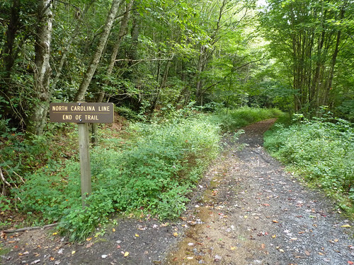
I let my front tire touch North Carolina soil
end of trail
and then turned around. It would be really interesting if some day the state of North Carolina continued the trail in their state. What would be really interesting is if some day the trail could be linked with the old Tweetsie line to form long mega-trail through Virginia, North Carolina, and Tennessee. I'm sure there's a long gap between where the two lines end, but one can dream.

I made my way back to Whitetop Station, passing mile marker 34.
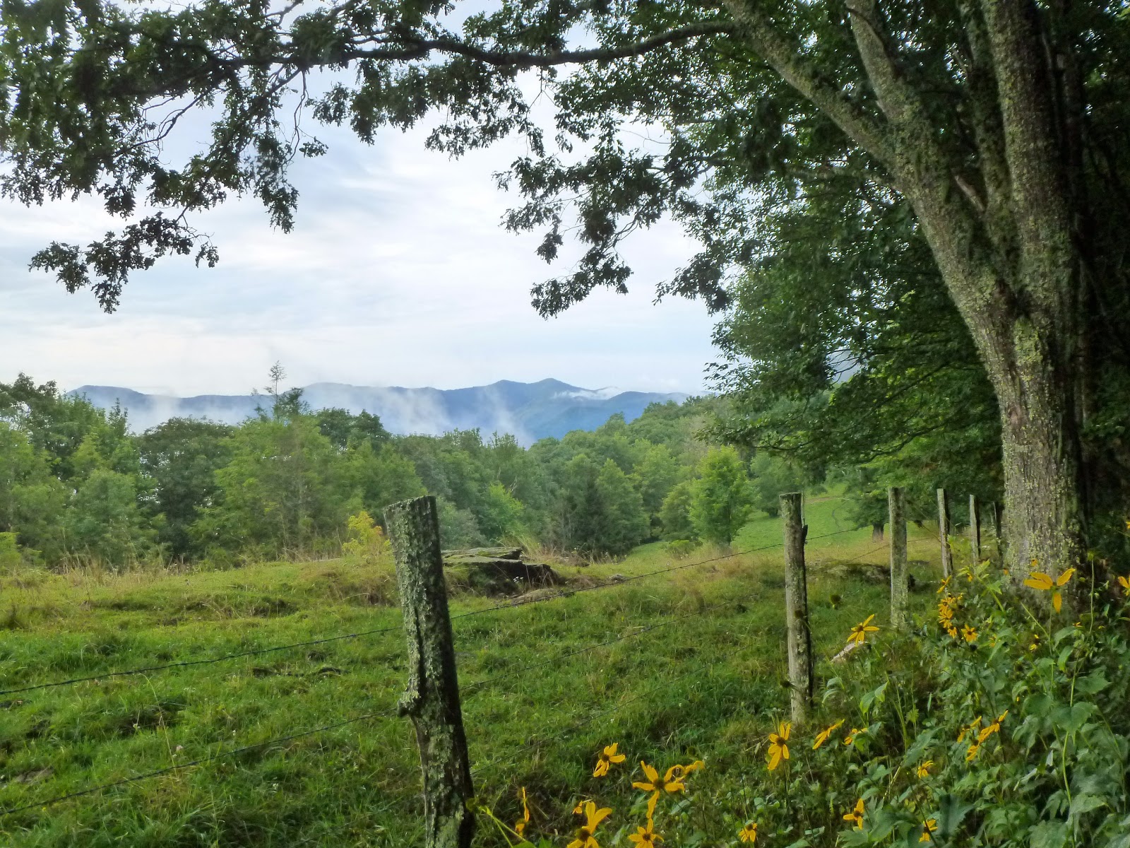
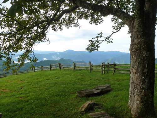
The rest of the ride is really a blur. It went very fast, being downhill. I did stop to check out a nice view from the top of another Christmas Tree farm
and then later at a small waterfall on Whitetop Laurel Creek.
Otherwise, the trip back to the car took 1/4 the time the trip up had taken.

Sunday, August 23, 2015

Great Smoky Mountains National Park: Hemphill Bald, Caldwell Fork, Rough Fork Loop

It was a solo hiking day today. I got an early start and hit the road a little bit after 5 am. I made the drive through Newport, east into North Carolina, through Maggie Valley, along the Blue Ridge Parkway and into the Great Smoky Mountains National Park. After a stop to observe an elk and the sunrise,
I was at the trailhead in 2 hours.

I put on my hiking boots and hit the trail in fog and generally dark skies.
The first part of the Hemphill Bald Trail followed an old logging railroad grade and offered extremely easy hiking.
As I moved on the lighting changed drastically. Sunlight peeked through the fog and left everything bathed in a strange yellowish orange light.
Parts of the trail closely followed the park boundary where an old CCC-built split-rail fence once kept cows from grazing in the park.
The trail began to climb a bit. First I ascended Whim Knob, then Little Bald Knob. The split rail fence then vanished and was replaced with barbed wire.
The park shared its boundary with Cataloochee Ranch at this point.

The trail along the boundary with Cataloochee Ranch was a bit overgrown. There were lots of wildflowers like white snakeroot, goldenrod,
and a yellow flower that I con not identify.
The land on the ranch property was grassy and open. There were lots of great views off to the south.
At one point I saw some folks driving a pickup on the ranch, later on I saw a few cows. Soon enough I found the summit of Hemphill Bald. The Southern Appalachian Highlands Conservancy has acquired a conservation easement for the summit, which sits on Cataloochee Ranch Property.
You pass through a stile and have a a nice grassy area in the shade of a buckeye tree to relax in,
Hemphill Bald view
complete with a stone table (with a built in peak finder) and benches.
The views are great from this lovely spot!

After a snack, I reluctantly moved on. It was a short hike to the junction of the Cataloochee Divide Trail. I, however, would be staying on the Hemphill Bald Trail for a bit longer. The trail started a long descent through the woods. There was not a whole lot to look at for a while.Then, all of a sudden, a huge Northern red oak tree appeared in front of me.
I had my photo taken with the giant and then continued on to the Caldwell Fork Trail. The 1.7 mile segment of Caldwell Fork I had hiked before. I passed by the closed campsite #41
and then started a relatively steep ascent.  I stopped at the "Big Poplars" like on my last hike through the area. As far as I can tell, only one of the trees remains, but it is just too impressive to pass by.
Soon after visiting the large tree I found myself at the junction with Rough Fork Trail.

Rough Fork started with a steep ascent, but soon joined the bed of an old logging railroad.
The hiking from that point on went very fast. I was back at the car just before 1 pm. Since 12:30 the sky had darkened and I felt a few drops of rain. Heavy rain never materialized though.

Saturday, August 22, 2015

Steele Creek Park: Lake Ridge, Lakeside Trails Loop

Today was a Bristol day. We did not realize that there is a race at the Speedway tonight. However, the traffic was not bad considering. We drove to downtown and opened Sierra a bank account at Wells Fargo, ate lunch at the always yummy Burger Bar,
and then headed over to Steele Creek Park for some hiking. Our first stop was the nature center where Sierra enjoyed looking at the fish and turtles. Just outside, near the porch, were some flowers that were loaded with butterflies.
We observed the butterflies and hummingbirds for a bit, then we headed out to hike the Lake Ridge Trail.

We crossed a shallow section of the lake on a trail causeway.
We saw lots of fish and turtles in the water.
When the causeway turned into a boardwalk we saw a few ducks as well.
Once we had crossed the lake, we headed into the woods.
The Lake Ridge Trail was a bit more difficult than I had anticipated. There were some pretty steep ascents and descents. Sierra walked the trail for a bit, but when she tired, she hopped into the backpack.
The trail comes to a point where you can see an old dam, but instead of crossing the dam the trail continues on traveling close to Steele Creek.

Finally, the trail crossed the creek on a bridge
and the trail on the other side is wide, gravel and not too steep. We saw some Virgin's Bower in bloom along the trail side.
Sierra found her first colorful leaves of the season.
A sign that autumn is just around the corner! We passed the dam that we had seen earlier in the hike.
It had been lowered at some point and a small waterfall was formed where the water tumbled out of the reservoir and into the creek. It was pleasant walking along the lake.
We saw lots more turtles and a green heron as well.

To keep Sierra motivated for the long walk, we promised her a ride of the Steele Park Train.
The ride is short, but Sierra enjoyed it.
After it had ended, we headed back to the car for the drive to Greeneville.