Sunday, May 25, 2014

Cherokee National Forest: Pinnacle Fire Tower Trail

After yesterday's long drive and hike, I opted for a hike a little bit closer to home and one that would be a bit shorter. I decided that the Pinnacle Mountain Trail up to the fire tower fit the bill perfectly. I made the quick drive over to Erwin, headed north on I-26 for a few miles and exited near the town of Unicoi for my hike up to the tower.

The trailhead is located at Jack Snider Park,
a Unicoi Town Park with a picnic area.

The trail starts into pleasant woods and gently starts to ascend.
There were some pretty big trees along the lower portions of trail and lots of wildflowers in bloom
including a pink lady slipper.
There were also lots of American chestnuts,
though they were all stunted little shrubs due to the Chestnut Blight. At about the halfway point of the ascent there is a nice view out across the "Valley Beautiful" to Unaka Mountain.
As far as wildlife, I saw a few centipedes
and many caterpillar-like larvae.
The climb never really got all that difficult, though there were a few short, steep sections. Before I knew it I was at the Pinnacle Fire Tower.
Pinnacle Fire Tower
There is a large, concrete C6 embedded in the ground near the base of the tower.
I'm assuming this is so the tower could be identified from the air. I climbed to the top to find two others enjoying the view. I ate a snack there and took some photos before heading back down to the car.
Eric at Tower
The trip back to the car was uneventful, though there were many more people out on the trail now, enjoying the beautiful weather.

Saturday, May 24, 2014

Beyond 6,000 in the Great Balsam Mountains

It was an early wake up this morning. I got up at 5:15, fed and walked Parker, and then hit the road. It would be a long 2 hour drive into the Great Balsam Mountains off the Blue Ridge Parkway. I arrived around 8 am, but found a parking lot already full with people parked all along the road, even in places that were clearly marked "No Parking". Yes, today's hike featured very pretty scenery, as well as lots of people.

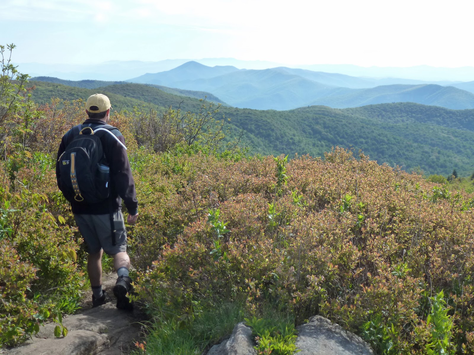
I started the hike by making my way through a large group of boy scouts that were loitering near the trailhead. I quickly turned onto the Art Loeb Spur Trail and ascended up to the main Art Leob Trail where the views were already amazing.
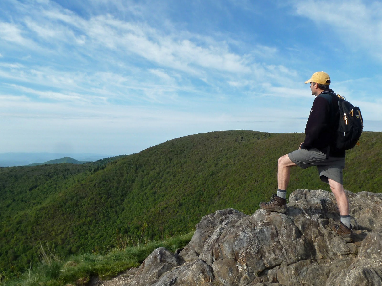
I stopped at a rock outcrop to admire the view and then moved on to my first peak-bagging objective for the day: Black Balsam Knob.
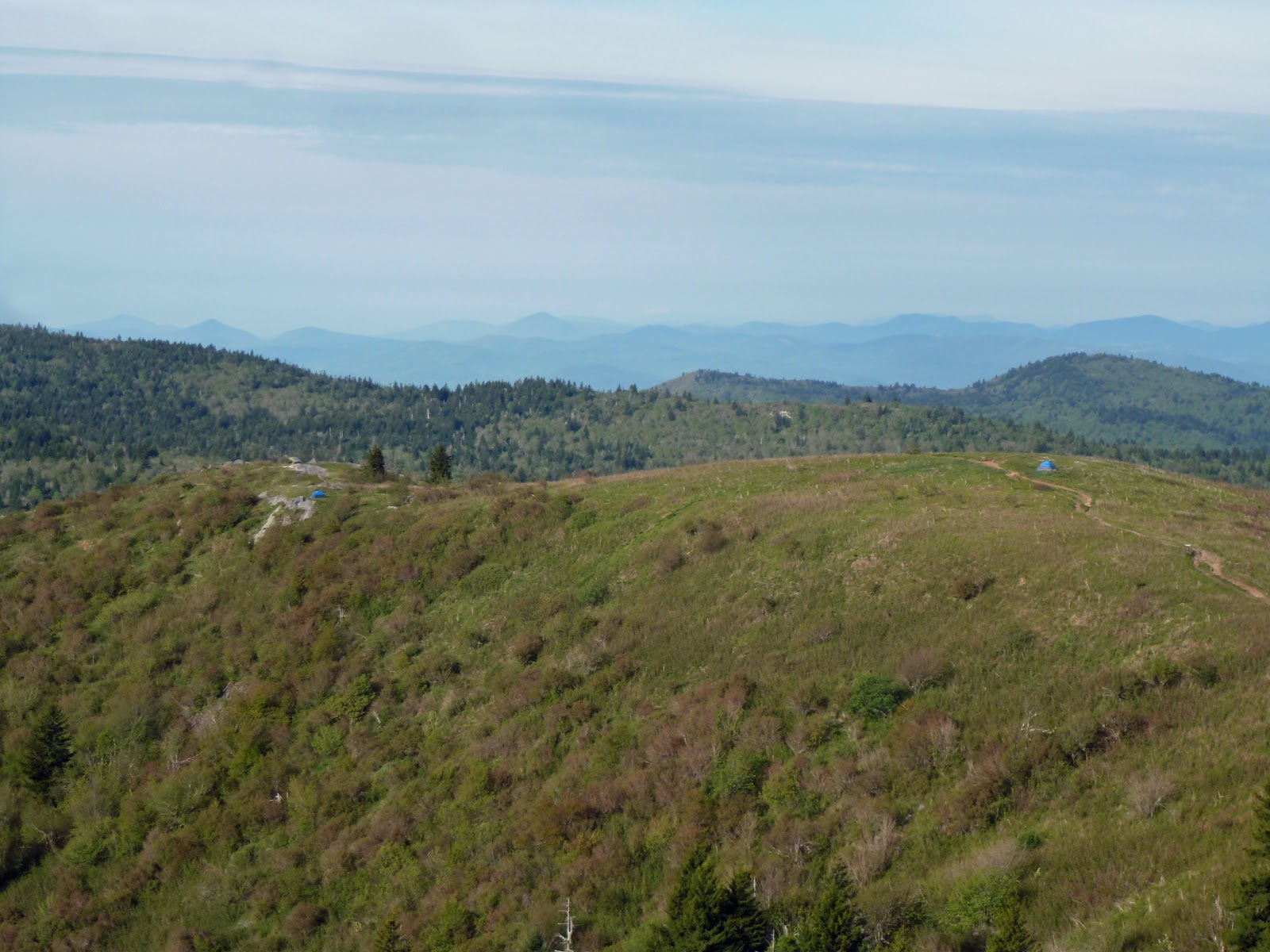
There were lots of tents scattered around on the grassy ridgeline,
including very near to the summit of Black Balsam. I stood on the small exposed rock outcrop that marked the summit, but with all the tents around I did not bother to photo document my conquest. I did notice an unusual little shrine set up near the summit though.

After a moment on the summit it was time to move on. The views remained spectacular due to the lack of tree coverage.
This lack of trees is not a natural phenomenon here. These mountains were logged extensively in the past and evidence of the logging operations could be found in the form of a cable exposed on the trail in a few locations.
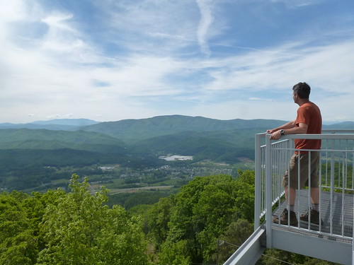
It was a quick walk over to Tennent Mountain where I photographed the summit plaque
and checked out the view near the summit.
Then I headed further north towards my next objective Grassy Cove Top.

Just before arriving at the base of Grassy Cove Top, the trail enters into the Shining Rock Wilderness.
The trails got a little bit confusing upon entering into the wilderness and I found myself on an old section of the Art Loeb Trail that was conveniently labeled as eroded.
I found the relocated, new trail and made my way around the east side of Grassy Cove Top's Summit. At the north end of the relocation, I followed the old Art Loeb Trail south up to the summit of Grassy Cove Top. It's just a small rock off to the side of the trail.
I took a photo and then moved on.

Soon my next objective came into view: Shining Rock with its line of exposed white quartz that seems to shine in the sunlight.
I descended through wonderful scenery to Shining Rock Gap.
Shortly after passing through the gap I found a trail leading to the right. I figured this to be the Old Butt Knob Trail. however, the trail was quite overgrown and the area it led into was a maze of social trails or "manways" as they are called in these parts. I picked my way through the maze and eventually found myself standing on a large boulder of snow quartz;
one of the two summit blocks of Shining Rock.
I ate a snack sitting on the cool rock and was soon joined by a group of boys from Durham. They soon moved on to the other summit and shortly after I tagged the second summit as well. I then headed back to the Art Loeb Trail via a better maintained trail.

I followed the Art Loeb Trail south for a bit to Shining Rock Gap. Here I left the Art Loeb and followed the Ivestor Gap Trail Instead.
This trail is actually an old road and hiking it was extremely easy and went very fast. There were limited views off to the west every now and then,
but generally the scenery on the Ivestor Gap Trail was not nearly impressive as on the Art Loeb. Before I knew it I was back at the parking lot. My hike, however, was not finished yet. I still wanted to hike over to a fifth and final 6,000 footer for the day: Sam Knob.

I had gotten lots of great views of Sam Knob throughout my hike, finally I would ascend it. The start of the Sam Knob Trail was level and easy, another old road I believe. Then the trail descended a steep rutted section into a meadow with an imposing view of Sam Knob.
The trail traversed the meadow and then headed into the woods for an ascent of Sam Knob. The hiking wasn't too difficult. There were lots of flowers in bloom,
but not much in the way of views until I reached the summit area. There are actually two summits to Sam Knob and I touched both of them, starting with the north summit. This summit features a wonderful view from a rock outcrop near a steep drop-off.
I lounged there for a bit and then headed over to the south summit. From the south summit I retraced my steps back through the meadow
and then back to a very crowded parking lot and road.

Tuesday, May 20, 2014

Greeneville's Creation Nature Trail

The good news is that there is now a hiking trail, within the town limit of Greeneville, on which you can walk with a dog! Now for the bad news.
  • There just isn't much to see along the trail. 
  • Lots of invasive plants like bush honeysuckle and English ivy.
  • Constant signs featuring christian religious messages. 
Still, it is nice to be able to go for a short drive and go for a hike with Parker. When we moved to Greeneville and I looked on Google maps, I saw Forrest Park and had assumed that there must be some kind of hiking trail in those dark green woods. There was not when we moved here but there is now! 

Today Noelle, Sierra and the extended family headed over to the park to enjoy the nice weather. We parked at Forrest Park (soon to be renamed Veteran's Park) and hit the trail.
I had read a story about the trail in the Greeneville Sun that described the trail as moderately hilly. I have to admit the trail was a bit more strenuous than I had anticipated.
It wasn't a problem for me or anyone else in my group, but I would imagine the walk could be tough for some hikers. There are plenty of benches to rest on though!
The trail was mostly wide as it had been created by bulldozer. There was one section of trail however, that got very narrow.

There was a sign for the Andrew Johnson Overlook which we took a spur trail to.
It turned out to not offer much of a view. You could see just a small portion of the National Cemetery through the trees. We hiked the 1.1 mile loop
and then spent some time resting in the grass in Forrest Park.
The most annoying part of the trail was the many signs referring to god and faith, etc. I have no problem whatsoever with people participating in faith-based activities. However, I prefer that my local government not spend my tax dollars to promote religion and not allow public spaces to be billboards for special interests. Still, it is nice to be able to go for a hike, on a nice dirt trail, through shady woods, close to home.

Monday, May 12, 2014

Pisgah National Forest: Black Mountain Crest Trail Mt Mitchell Parking Lot to Celo Knob

It had been a long time since I had gone on a solo adventure! Today I took my opportunity to do some peak bagging in North Carolina's Black Mountains. I awoke at 6 am, walked the dog and threw my gear into the car for the drive through Weaverville, up to the Blue Ridge Parkway, and over to Mount Mitchell State Park. I parked the car at the trailhead for the Deep Gap Trail which is also known as the Black Mountain Crest Trail. This trail is where I would spend the vast majority of the next 9+ hours of my life.

The trail started with an easy, well-graded, downhill walk to a gap
and then a not-too-tough ascent of Mount Craig which I had ascended back in November. Today however, I cruised right past the summit to continue on in my quest to ascend all the 6,000 foot peaks in the southeast. Just past the summit of Mount Craig was a wonderful overlook of the rest of the Black Mountain Range.
I would be ascending all the peaks on the ridge, and from that vantage point my task did not seem all that difficult. Things were about to get a whole lot tougher though.

From the overlook on Craig I descended to a small col between Craig and Big Tom, and then asended to the summit of Big Tom. Big Tom is named for Big Tom Wilson a mountain man who discovered the body of geologist Elisha Mitchell. I snapped a quick photo of Big Tom
and then continued on heading down into another gap. Along my hike I was treated not only to wonderful mountain views,
but also glimpses of some wildflowers that had ceased blooming in the lowlands weeks ago
including several varieties of trillium.
I ascended out of the gap and up onto the summit of Balsam Cone.

From Balsam Cone it was another descent into a gap and then an ascent up to the false summit of Cattail Peak. There is a sign indicating Cattail Peak just off to the side of the Black Mountain Crest Trail.
However, this sign is inaccurate. The true summit requires a quarter mile bushwhack up the ridge to the summit. There is supposedly a benchmark on the summit of Cattail Peak, but I could not find it. If I did not find the true summit of Cattail Peak, I must have been very close to it as I scoured the ridge twice. ( The second time being on my return hike.)  After Cattail Peak it was a quick descent and then ascent up to Potato Knob.      

From Potato Knob it was a long steep descent
into Deep Gap and the first legal campsites on the southern end of the trail. As I made my way down, I could see my next objective for this hike through the trees: Winter Star Mountain and its sister summit Deer Mountain.
I made my way up Winter Star and found a benchmark at the summit.
Then it was yet another descent down into a gap with a climb back out. Views opened up to my final two major objectives: Gibbs Mountain and Celo Knob.
Unfortunately, they were still a pretty long ways off. By this time I was starting to understand the difficulties of the trail. While I had read how difficult the Black mountain Crest Trail is, I really thought what I had read were exaggerations and truly underestimated the difficulty of the trek. Still, I decided to continue on.

After climbing out of the gap between Winter Star and Gibbs Mountain the views really opened up.
There were frequent high meadows off to the side of the trail. The directions to Gibbs that I had copied off the Carolina Mountain Club website were confusing and so I decided to skip the ascent of that mountain until another day. Instead I headed to Celo Knob
under a darkening sky. There is a user trail that branches off the official Black Mountain Crest Trail just past Horse Rock. This trail, though quite faint, leads to the summit of Celo Knob. I followed it to the summit where I took a break and studied the topo map to see if I could gain any new insights into finding the summit of Gibbs Mountain.
The problem with the map is that it states the elevation of Gibbs to be 5,545 feet; clearly not a 6,000 footer. I should have done more research before I left. However, on the bright side, my inability to ascend Gibbs
gives me another excuse to make a trip up into the Blacks sometime in the future.

From the summit of Celo Knob I found my way down to the Black Mountain Crest Trail and started heading back to the parking area near Mount Mitchell. I was definitely starting to feel like I had bitten off more than I could chew. I still had a long hike back to the car under increasingly dark sky
with rumbles of thunder every now and then. To make matters worse, my thighs were starting to cramp quite severely.  I soldiered on though. What else could I do? Because I was so tired, I had little energy for taking photographs. I simply put one foot in front of the other and continued on as best I could. I ate my last granola bar and drank my last bit of water before I even made it back to Potato Knob, but luckily I arrived back at the car dry just after 6 pm for my long drive back to Greeneville.