Tuesday, February 19, 2013

Dripping Springs and Squaw Peak

I spent the night in Las Cruces last night because I was supposed to pick Noelle and Sierra up from the airport in El Paso around 2 pm and I figured if I stayed close to El Paso I would have the opportunity to go for a hike in the morning. I awoke this morning, got a breakfast burrito at a gas station, and headed into the Organ Mountains.

After checking in at the visitor center, I hit the trail. I opted to hike to Dripping Springs and make an ascent of Squaw Peak before I headed back to the car. I had been to Dripping Springs before with Noelle. It had been a long time though, and so I was excited to return and experience the area again. As I made my way into the mountains I was treated to some wonderful views of Squaw Peak, my objective for later in the morning.
Eventually I headed towards a canyon among the high, jagged peaks of the Organ Mountains.
Dripping Springs was once a resort and later the site of a sanatorium. There are lots of structures and ruins left from the days of old. The first set of structures that I encountered were some stables and a corral.
As I headed further up into the canyon I encountered the ruins of the old resort hotel.

From the hotel ruins I followed the trail up to the the old sanatorium.

Behind the sanatorium building was a mostly intact house
and some low wall ruins. There was also a trail there that led to a dam above Dripping Springs. This was the water source for the hotel and sanatorium.

After exploring the ruins for a bit I started to make my way back towards the parking lot. By this time the early morning's blue skies had given way to overcast and the wind began to pick up.
Still, I was determined to make my way to the summit of Squaw Peak and so I eventually left the trail and made my way cross-county to one of the ridge that ran up the mountain. At first the ascent was gentle, but eventually it got steep. In fact, I was forced to use my hands quite a bit as I made my way upward. As I made my way higher the winds got quite fierce, but eventually I topped out onto the summit of Squaw Peak.
I admired the view up there for just a few minutes before retracing my steps down to trail.
Along the way I found a shed deer antler.
When I approached the car I decided to turn my phone on just in case Noelle called me with information about her flight. Unfortunately, she had left a message telling me her flight had been cancelled due to high winds. After talking with Noelle I learned that she will try to fly into El Paso tomorrow instead. sadly, I will have to wait an extra day to see my girls.

Monday, February 18, 2013

Saguaro National Park: Cactus Forest Trail

The drive from Picacho Peak to Tucson was uneventful, but the amount of sprawl in Tucson was astonishing. I'd been through Tucson before, on a visit to Saguaro National Park about 11 years ago, but things seemed even more sprawling now. I made the long drive through strip malls and traffic on Broadway until I finally found Old Spanish Trail which I followed into the park.

Once in the park I visited the visitor center and picked up a site bulletin on hiking trails so that I could plan my course of action. Since I didn't have a car on my last visit, I decided I would drive the scenic loop road and hike a few of the short trails along the road including the Cactus Forest Road. After purchasing a patch and magnet at the bookstore I set out to the road.

The drive was pleasant. The day was warm, but thanks to mostly overcast skies it was not too hot. I hiked a short nature trail and then moved on to the trailhead for the Cactus Forest Trail.
The trail, like the drive was very pleasant.
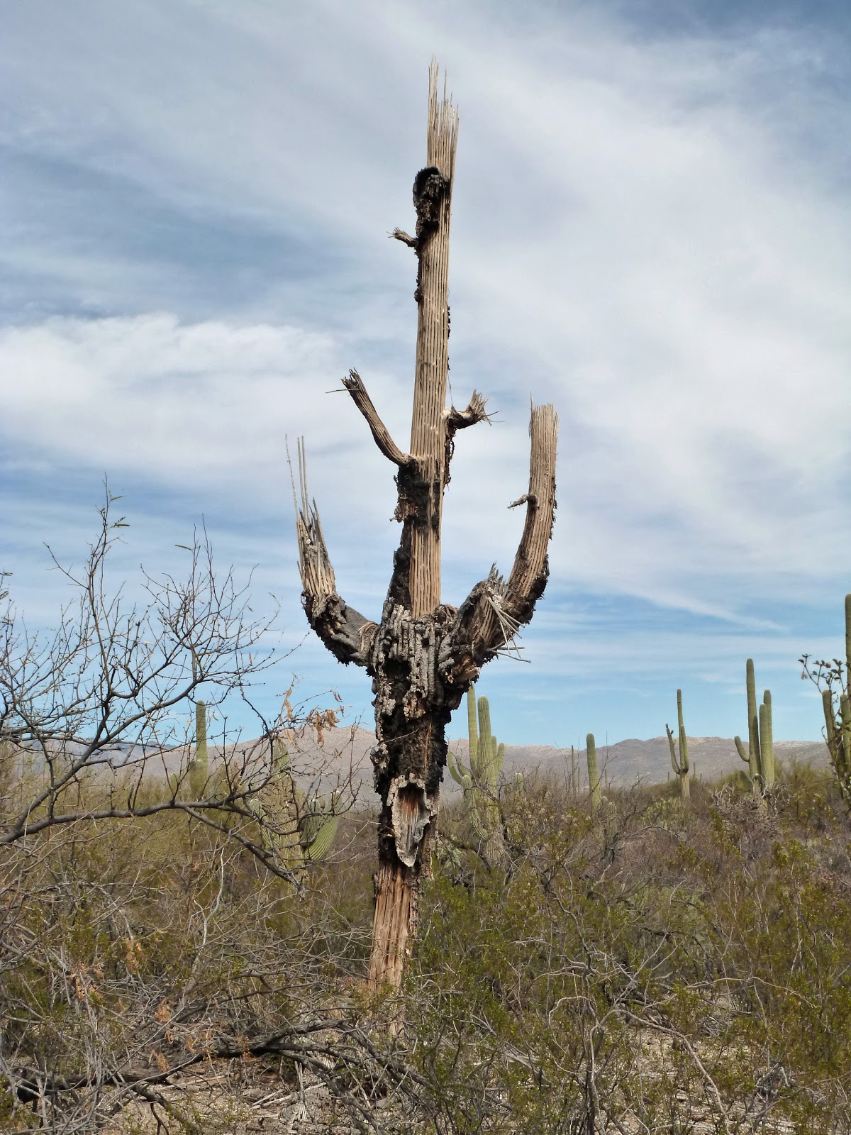
There were lots of saguaros along the trail of course, and I found myself wanting to photograph each and every one.

Even the skeletal remains of the dead ones were interesting.
There were also lots of great views of the surrounding mountains
and the views got me reminiscing about my hike up Tanque Verde Ridge to Manning Camp on my last visit.

Eventually I came to the site of some old lime kilns
and shortly thereafter I took a side trail that lead to Lime Falls. I wasn't sure what I would find at the falls, but I was curious. I knew there would be no rushing waterfall, still I had to see what as there. I found the dry falls and decided to see what lay above. Above I found a small pool of water and a small white-tailed deer who I presumed had just stopped by for a drink.
I have to admit, I was surprised to see a white-tailed. I would have expected to see mule deer living in such an arid environment.

After visiting the falls I retraced my steps and continued on the Cactus Forest Trail. There were even more impressive specimens of saguaros as I hiked along. I came to the other end of the trail, stopped for a snack and then retraced my steps back to the car. Along the way I passed not only saguaros, but barrel cactus
and chollas as well.
When I had returned to the car I realized that my time in Arizona was coming to an end. While I had enjoyed myself in the Grand Canyon State, I was excited to see my girls, Noelle and Sierra, again.

I had one more stop before I hit the road, another short nature trail that led to an old homestead. While there was not much left of the old homestead I did get to see some birds: a thrasher
and a phainopepla.

Picacho Peak State Park: Hunter Trail

After my hike up Piestewa Peak last night, I got out of Phoenix and headed south towards Tucson. I made it as far as Eloy, AZ and even got some dinner at Culver's. This morning I awoke early and made the short drive down to Picacho Peak State Park. I arrived just after the park opened and headed over to the trailhead for the Hunter Trail.

After arranging my pack I hit the trail. The walk was pleasant with lots of great views.
The trail seemed tame enough as I slowly ascended the distinctive Picacho Peak among plentiful saguaro cacti.
The hike remained pretty tame until I reached a saddle between the main Picacho Peak and a small sub-peak. From the saddle there was an extremely steep descent along the west side of the mountain. It was so steep in fact, that there was a cable handrail to hold onto as I made my way down. This would be a sign of things to come.

After descending down to an elevation roughly that of the trailhead, the trail began to ascend again. There were some extremely steep sections and lots of cables to hold onto. In fact, I would call this ascent less a hike and more of a scramble. The cables added to the fun of the hike and after a short time I ascended through a forest of saguaro,
up a last cable section
and onto the summit.
There were great views of the surrounding desert and the interstate connecting Phoenix with Tucson. A little ground squirrel friend joined me up there.
Perhaps he or she was used to getting scraps of food from hikers.

After a short time on the summit I began my descent.
While I pretty much had the place to myself on the ascent, there were lots of others now making their ways up the mountain. I figured things could get interesting at the cables on a busy day like today (it is President's day after all) and I was glad to be getting down when I was. After the saddle, the hiking got fast and easy
and I was back to my car in no time at all ready to head to Tucson and Saguaro National Park.

Sunday, February 17, 2013

Piestewa Peak Park: Piestewa Peak

After my hike on the Bell Trail I hit the road headed south towards Phoenix. I was excited to see some saguaro cacti, but as I drove I didn't see any saguaros. I headed further and further down in elevation, but still no tall cacti, then I crested a ridge and they were everywhere! I decided right then that I wanted to hike among them and I didn't want to have to wait until tomorrow. I had remembered seeing a hike on the north side of Phoenix and so when I stopped the car for gas I looked up the hike and traced out a route to get there. The hike was at a place called Squaw Peak Park and ascended to Squaw Peak itself.

As I made my way through the sprawl that is greater Phoenix, I had a remarkably easy time finding the park, but the entrance was blocked off when I arrived there due to, as I would learn later, a search and rescue operation. I followed the lead of the others and parked outside the park on a side street and walked in. Soon after entering the park I found the Summit Trail and started my ascent.

There were lots of people on the trail, after-all it was a beautiful day and President's Day weekend as well. The ascent was surprisingly steep and I spent much of the hike passing other hikers and getting passed by runners. There were lots of saguaros to gawk at along with the people.
Eventually I found myself at an exposed rock outcrop that was covered with people.
I supposed this to be the summit and sat down for a rest.

As I was sitting I realized that another, nearby rock outcrop was the true summit. It looked very exposed, but after looking around I found a safe route up to the top.
There was some old graffiti up there
and great views of the surrounding metropolitan Phoenix area. I spent some time people watching, contemplated watching the sunset from my high perch, but then decided against it and started my way down.

Despite the waning sunlight there were still lots of people making their way the mountain as I made my descent. While I didn't get to see the sunset from the summit, I did get to watch as the sun slowly made its way lower on the horizon and painted the mountain, cacti and rocks orange until it disappeared.
I did get to see the actual sunset, but from a much lower elevation than the summit.
I also learned that the peak is no longer referred to by the politically incorrect Squaw Peak, but now goes by the name Piestewa Peak, named after Lori Piestewa, a part-Hopi woman soldier who was killed in Iraq.