Tuesday, January 20, 2015

Great Smoky Mountains National Park: Charlie's Bunion via Kephart Prong and Sweat Heifer Trails

My first Smokies hike of 2015! I packed my stuff last night and hit the road early this morning. I would drive through Gatlinburg (early morning is the best time to do that) and up over Newfound Gap to arrive at the Kephart Prong Trailhead by 8:45.
This was the first time I had been south of the Clingman's Dome Road on US-441. I hit the trail crossing over the Oconaluftee River
on a sturdy footbridge.

The Kephart Prong Trail is an old road that very closely follows Kephart Prong. After just a short walk I came to the first attraction of the day, the site of an old Civilian Conservation Corps camp. There's a little bit of the camp still left including an old sign board,
a drinking fountain,
a large chimney,
and an ornate pipe sticking up out of the ground.
After exploring the camp site for a bit I got back on the trail crossing a log footbridge. Eventually I came to the site of an old cistern which I assume held water for the CCC camp.

From the cistern the trail crossed the cascading Kephart Prong
again on a footbridge.
At one point there were a bunch of railroad tracks scattered along the side of the old road.
Some of them were so overgrown with vegetation that they were barely visible. The site made me wonder if this old road was once a logging railroad. Soon I found myself at the Kephart Prong Shelter.
I stopped for a break, read the register, and ate a snack. Then I moved on and away from Kephart Prong
for the steep ascent on the Sweat Heifer Trail. Actually the ascent was not as bad as I had been led to believe from things I'd read on some blogs. Parts of the trail seemed to follow an old road bed, while others were obviously more recently constructed foot path. At the top of a ridge the trail came to an area with a pile of rusty metal debris.
Nearby was a flat area that looks to have seen some major human use. On the old road bed there I found quite a bit of coal littering the ground.
It was a short ascent from there up to the Appalachian Trail.

Before reaching the Appalachian Trail I had seen some patches of snow and ice here and there. Once I reached the AT however, the snow and ice became a nearly constant companion.
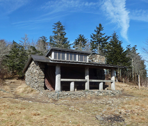
I was beginning to wonder if I had made a mistake in not packing my microspikes. I made it to the Icewater Springs Shelter in one piece though.
Icewater Springs Shelter
There I took a break and ate a snack while basking in the sun. The last time I had been at this shelter was about 15 years ago during my thru-hike. I had left my rain pants there by accident and did not realize it until I was miles away. I looked for them, but they were nowhere to be found. There is a pretty nice view from the front of the shelter.

After my break I got back on the trail. The section north of Icewater Springs was a veritable luge run.
I ended up having to skirt around the side of the trail to avoid a major catastrophe. Eventually the trail cleared though.
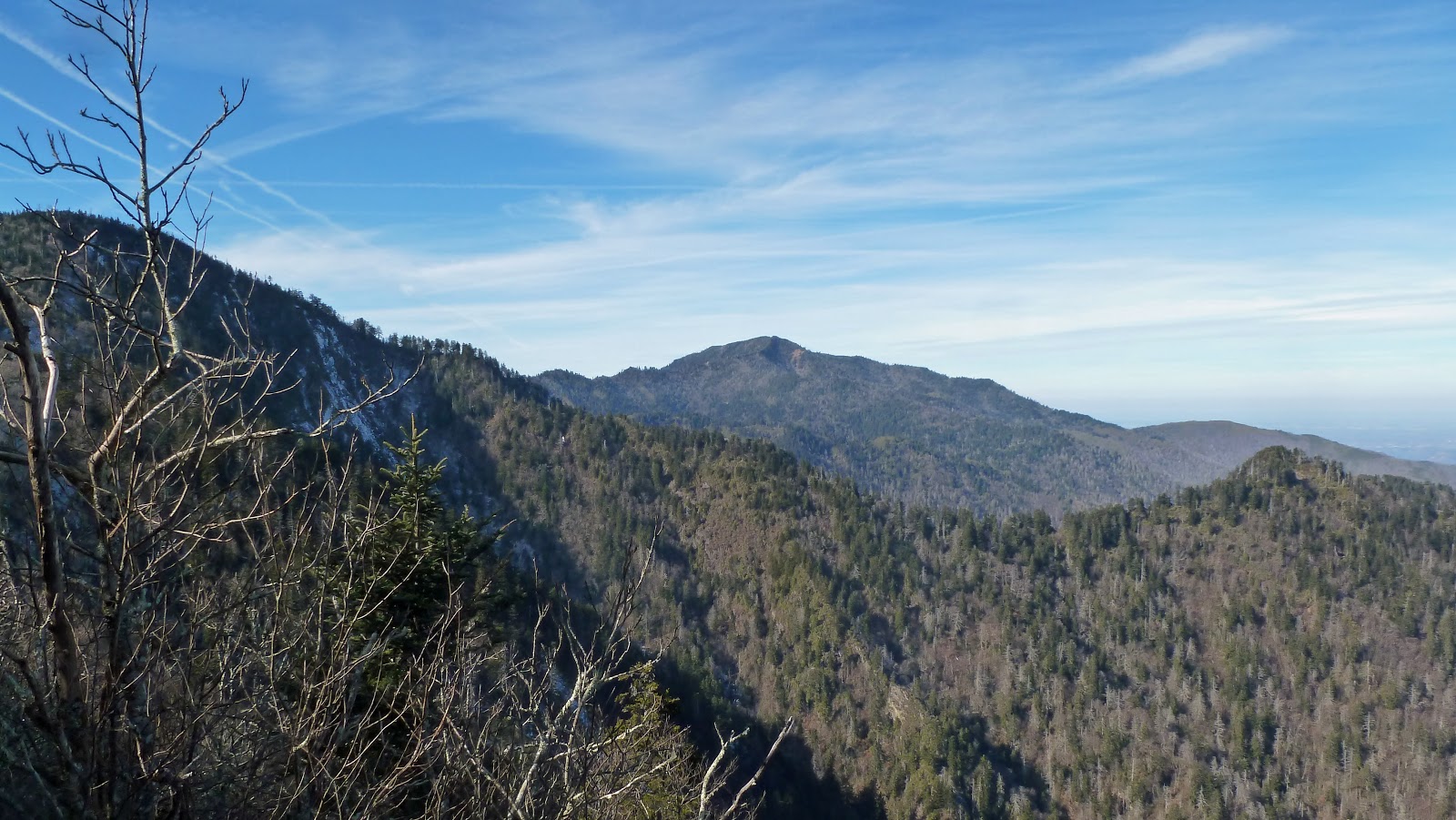
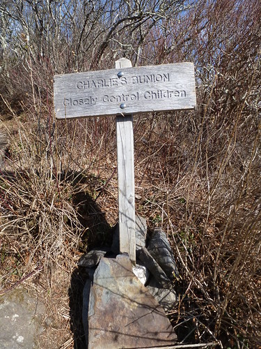
By the time I reached Charlie's Bunion, the ice was a thing of the past. I enjoyed the view of nearby Mount LeConte
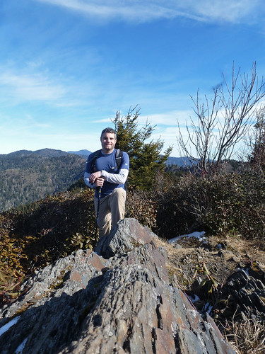
and climbed up to what some refer to as the "Real Charlie's Bunion" (as opposed to the "tourist Bunion"). There were two trails there. One went over to the bunion
bunion sign
while the AT skirted around to the side of it. If I remember correctly the AT followed the bunion route back when I had thru-hiked. I posed for a photo at the bunion
at the Bunion
and then headed north on the AT.
There were some nice views along this section of the trail.
I didn't realize it last time I hiked along this section though due to the fog and rain.

When I reached the Dry Sluice Gap Trail
I turned right and started an ascent before descending quite steeply. Mostly I just hiked very fast along this trail and the Grassy Branch Trail. I did stop to observe a grouse, but did not get a good photo.  I was back at the car in a little over an hour and a half from the AT. It was a great hike, but a long drive back to Greeneville. I decided to go through Cherokee since I had never been through there before. I thought maybe it would be faster, but it did not seem very fast.

Sunday, January 18, 2015

Panther Creek State Park: Lost Road Trail

This is the type of state park that the Grunwald family normally avoids since it contains a large, man-made reservoir. However, with surprisingly nice weather today we just had to get out and take advantage and so we headed over to Morristown and Panther Creek State Park. We opted to hike the 3.5 mile long Lost Road Trail.

The trail was nothing special, but it was nice to just get out into nature and enjoy the pleasant weather.
We started with an ascent up a bunch of tightly spaced switchbacks and hiked past at least one old homesite with a sunken foundation and the remains of a chimney.
Eventually we reached a ridge and shortly after starting a descent we met a hiking partner, a dog whose tag claimed she lived just outside the park and knew to come home at night.

We soon began a descent down to the Cherokee Reservoir. The water level was very low,
presumably because the reservoir is drawn down for the winter and spring rains.
From the reservoir we ascended again, passing through limestone, karst landscape with some sinkholes.
Then we were back to the car for a short drive over to the playground so that Sierra could play for a bit before the drive home.

Sunday, January 11, 2015

Cowpens National Battlefield

We ate lunch in Gaffney and then headed over to Cowpens to check things out. Originally, I had planned that we would visit Kings Mountain one day and save Cowpens for the other. However, rain is forecast for tomorrow and quite a bit of it. As a result we decided to explore Cowpens today.

We checked out a large monument just outside the visitor center
and the exhibits inside the visitor center before we headed outside for a walk along the 1.25 mile long Battlefield Trail.
The scene here was not as impressive as at Kings Mountain, but it was still a nice walk. Sierra was pretty tired by this time and so she was in a slightly cranky mood. Sure enough, Sierra fell asleep in the backpack.
There aren't many monuments on the battlefield here, but there were some interpretive signs to describe the action
and a small monument built by the Washington Light Infantry way back in 1856.
It was a quick visit, but an enjoyable one.


Kings Mountain National Military Park

After checking out the amazing Peachoid, Noelle, Sierra and I headed further up I-85 and briefly into North Carolina. We exited the interstate and quickly headed back into South Carolina and into Kings Mountain National Military Park. We parked the car outside the visitor center, ate a snack
and then checked out some of the exhibits inside. After that, we hit the trail. We opted to hike the short 1.5 mile Battlefield Trail.

The was on a paved trail through a pleasant section of woods.
There were lots of points of interest along the way to stop, admire and read about. Our first stop was a set of monuments that were dedicated to the memory of William Chronicle, a major in the American forces.
From the Chronicle Monuments we made our way further along the trail, crossing a small creek several times on bridges.
The next major point of interest was a plaque that had been affixed to a boulder that marked the spot where President Hoover addressed a crowd who had gathered for sesquicentennial of the Battle of Kings Mountain. There were apparently over 75,000 people crowded together on the slopes of the mountain to hear Hoover speak. 

Soon after the Hoover Monument, the trail started to ascend to the spine of Kings Mountain. We came to the Centennial Monument which had been built in 1880 to commemorate the 100th anniversary of the battle.
We then our way over to the most impressive of the monuments: the US Monument.
The US Monument is like a small version of the Washington Monument in Washington DC.

From the US Monument the trail started to descend. We soon came to a stone marking the spot where British Major Patrick Ferguson fell.
Nearby we found Ferguson's grave which was originally marked by only a cairn of stones. Today there is also a headstone.
From Ferguson's grave it was a short walk to the visitor center where Sierra enjoyed climbing on the low wall outside.
Inside she was able to earn herself a medal for hiking the trail and becoming a patriot.