Saturday, August 29, 2009

Rocky Mountain National Park: Longs Peak

It was cold when we woke up at 2:45 this morning. We got dressed and packed up camp as quickly as we could. We then got in the car and headed to the Longs Peak Trailhead. We got to the trailhead at 3:20 and it was already packed! There were cars everywhere. We ended up parking about a half a mile down the road from the trailhead. We hit the trail at 3:45 in the cold and dark. It quickly became apparent that we were not alone. As we looked up the trail we would see headlamps in the distance. We moved pretty quickly too!

When we hit tree-line the sight of a line of shining headlamps snaking up the mountain was incredible. Never before have I seen such a sight! We were part of an army of people marching up a mountain in the darkness.
Start of Boulderfield

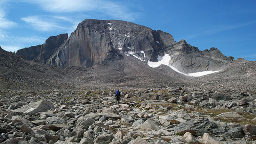
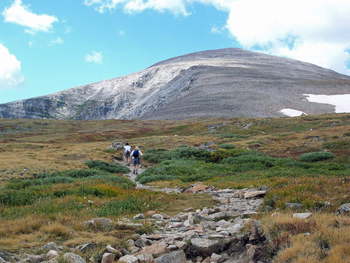
The sun finally started to shine when we reached the Boulderfield with the Keyhole now visible. In the sunlight you could better see all the people who hoped to achieve the summit. Some of them seemed to be making easy work of the rugged terrain, while others struggled mightily.
From the Keyhole things got even more difficult. There was a narrow ledge that we made our way across before some serious ascending up the Trough. The Trough was incredible.

It was almost as steep as the Manitou Incline that Kris and I had hiked up a few weeks ago. Only this time there were no stairs to walk up; only scree and loose rocks that occasionally were misplaced by climbers to a chorus of “rock!” The Trough left us thoroughly tired, yet we still had quite a bit of ascent to go.
From the Trough we moved up the Narrows. The climbing was again difficult and the air was thin. We took lots of breaks. Finally we crested a ridge and there she was, the objective of our strenuous climb: the summit of Longs Peak. There were lots of people up on the flat summit. We lounged on some rocks for a while, ate a snack, and then we signed the summit log and Kris took my photo on the summit.

We didn’t spend much time up there though, there were some dark clouds moving in.

As we made our way down off the mountain our progress was slowed by the traffic jams caused by people moving in both directions. We still made pretty quick time though. We were back to the Boulderfield in an hour. I used the toilet there and then we rested on a nice flat boulder in the sun. It started to look even darker and so we moved on.

Despite the dark clouds and the rumble of thunder, people still continued to head up the mountain. Soon slushy precipitation started to rain down on us. I couldn’t believe that few people seemed deterred by the weather. I thought the descent was difficult enough without the rocks being wet. Kris and I both agreed that we were glad to be down where we were and not up on the summit at this time. When we reached tree-line things did seem to clear up a bit. Soon the sun was shining and before we knew it we were back to the car. We had spent a total of 9 hours on the mountain. We had made quick work of our ascent (and descent) indeed!

We were starving when we got back to the car and so on our drive through Boulder we stopped at Qdoba for lunch. We then got our weary bodies back into the Civic and headed to Kris’ Denver apartment where I showered and took a nap before heading back home to South Dakota.

Friday, August 28, 2009

Roosevelt National Forest: Mount Audubon


Today was the start of the weekend during which my brother Kris and I had planned on climbing Longs Peak. After work last night I drove west into Wyoming and south into “Colorful Colorado”. I arrived in Denver just around midnight. Since Kris had to work today, I decided I would do some hiking on my own. Upon looking through my copy of 100 Classic Hikes in Colorado, I decided that mount Audubon had all the requirements I wanted in my hike: a tall mountain (13,233 ft.), beautiful scenery, and close proximity to Denver.

After a quick morning trip to REI to return some zip-off pants I headed into the mountains to Brainerd Lake. The drive, while beautiful, turned out to be longer than I had anticipated. I ended up not getting to the trailhead until about 12:30, much later than one would normally want to arrive at the trailhead to hike up a 13er.
Luckily, the hike was supposed to be fairly easy and I figured I could complete it in quick time.
Hiking up Mount Audubon

The hike indeed turned out to be none too difficult. I made quick time of the ascent. I was up on the summit in just over two hours.
From up there I could see my destination for tomorrow: Longs Peak!
Longs Peak from Mount Audubon

I had the summit all to myself and since there was no register to sign I headed down after a few minutes. I was back to my car an hour after leaving the summit. A fast 3 hour hike!

After my hike I went looking for a campsite for Kris and me for the night. If we were going to make the trail by 3:30 tomorrow we would need to camp somewhat close to Longs Peak. The closest campsite I could find was at Dick Camp. I got the last site available, a double site for $20. I set up the tent and drove back to Denver to pick Kris up. We ate dinner at his apartment, and then drove back for the night.

Friday, August 21, 2009

Bighorn National Forest: Cloud Peak

What a day! What a long, tiresome, dehydrated, sunburned, mosquito-bitten, blister-ridden day. It all started with a 5 am wake-up. I packed up camp and drove from the campground to the West Tensleep Trailhead. It is from here that the death march began. The hike started off innocently enough. The hiking was pretty easy apart from a ford of Tensleep Creek. The views from Lakes Helen and Marion and Mistymoon Lakes were amazing. I made it the 8 miles to Mistymoon Lake in 3 hours. Things were looking pretty good. However, the tough part of the hike was just about to begin.
Young Bull Moose

From Mistymoon Lake I followed the established trail down to Paint Rock Creek. From Paint Rock Creek I followed a well-used user trail up the drainage and into some beautiful, but rugged country. The hiking started to get a bit steeper and tougher and then the trail petered out. From here on out I would be forced to use my own route-finding skills. To make things even more challenging the hiking turned into rock-hopping and the air got thinner. Soon there was snow, and quite a bit of it.

I had to be really careful where I placed my feet. If I made a false move I would be post-holing up to my crotch. I found the most efficient way to move was to keep hopping from boulder to boulder unless there was a well worn path in the snow.

As I headed higher up the mountain the going got tougher, the altitude more obvious, and the sun brighter. I wished I had some sunglasses to shade my eyes from the constant sun glare. In addition, I had a pounding headache, not from altitude, but from dehydration. When I finally reached the summit at around one o’clock I was pretty much spent. I was not alone up there though. I met a party of two just below and passed a party of three, one of whom was packing heat (I’m not really sure why he felt the need to carry a pistol with him.) on the final stretch. I was able to relax a little bit on the summit and had one of the three I had passed earlier take my photo on the summit boulder.

I didn’t spend too much time up on top though. I still had a long way to go to get back to the car; ten miles to be exact. I also wasn’t too thrilled with the thought of the decent. Things went better than I had envisioned on the snow and boulders and I was back on the established trail in less than 2 hours. I was getting really tired though and still had 8 miles to hike at this point. Luckily the rest of the hike was mostly downhill. I didn’t stop to take many photos on the way back. I was just too tired and didn’t want to waste too much time. I needed to get back to the car before dark.

Well I made it to the car at 6:45, well before dark. I was very, very tired though. I still had a long drive ahead of me too. I stopped in Buffalo for dinner, before heading east to good ol’ South Dakota. I don’t think I’ve ever felt so relieved to be home. I pulled into my parking lot at 11:45, took a shower and hit the sack.

Thursday, August 20, 2009

Bighorn National Forest: Circle Park Loop

I had wanted to visit the Bighorns all summer. Despite the fact that I had the evening program last night, I was determined that this would be the weekend to do it. Last night after the evening program (which I presented in a driving rain) I made my way home to change and jumped in my packed Civic. It was already 9:30 when I hit the road and I was pretty tired but I was itching for some fun in the mountains. I made it as far as Gillette, Wyoming before my drowsiness forced me to stop for a hotel for the night.

When I woke up this morning I was ready to go. I got some breakfast and bought some last minute food items before driving I-90 west towards Buffalo. The morning was beautiful. It looked like it was going to be a great day for a hike. I pulled into the Circle Park Trailhead at around 10. I soon hit the trail with my first destination Sherd Lake.
Sherd Lake
The hiking was pleasant with the temperature nearly perfect. Sherd Lake was pretty, but I had to move on. My next stop would be Willow Lake.

Willow Lake was okay, but not too spectacular. I decided to hike up past the inlet of the lake to see if I could get a better view. I was rewarded not only with a spectacular view of the mountains and Oliver Creek, but with a bull moose sighting as well!
What a magnificent looking animal. From Willow Lake I backtracked a bit before heading over to Old Crow Lake.
Old Crow Lake
Wow! Old Crow offered the most beautiful scenery yet. I stopped there and rested a bit before continuing on. Trigger Lake was the next stop on the “Lakes Tour”. While it was a pretty spot, it was not as jaw-droppingly pretty as Old Crow. I finally completed my loop by heading back to Sherd Lake before returning to the trailhead. What a great hike. I only wish Noelle was with me to experience it.

After my great hike I headed farther west. I took a rough side trip to Sheep Mountain Lookout Tower
before finding a campsite for the night at Deer Park Campground. I had the place all to myself. The quiet here should offer plenty of rest for tomorrow’s adventure: a day hike up Cloud Peak. The roundtrip is about 20 miles. It should be challenging, but I’ve hiked 25 miles up and down Pikes Peak.

Friday, August 14, 2009

Wind Cave National Park: John McDill Memorial Run

Tonight Noelle, myself, Mike Kali, and Nick (Team Springtails) ran in the McDill Memorial Run. It’s a 10.2 mile relay in which each member must run at least one mile and at most five miles. Each team must have at least two members, but we were glad to have the maximum of five because it meant each person had to run a shorter distance. Nick ran the lead off leg in pretty quick time.
He handed off to Mike, who handed off to Kali. Kali passed the baton on to Noelle who passed it on to me for the anchor leg.

Our team came in last, but we had a lot of fun. I was pleased with how well I ran, especially considering I had done little to train for it. I timed two miles of the approximately 2.5 miles that I ran and was on a sub-7 minute mile pace. Not bad, especially considering I had a brutal uphill section in my run. After it was over there was watermelon, Dr. Pepper, and Twizzlers at the finish line. Team Springtails then went over to Nick and Kali’s for a delicious dinner.

Wind Cave National Park: Boland Ridge

Noelle and I finally made it out to Boland Ridge to do some hiking. Since this is our favorite hike in the park, it’s hard to believe it took us so long to get there. Well the hike was not bad. The weather was much cooler than it had been and the trail was well defined thanks to the fence crew using it as a road to get to the fence in that part of the park. However, for the first time we did not see any elk while hiking there (not any live elk at least).

We also spent a little bit of time to check out the deep, narrow canyon back there that some former park employees named Canyon of the House Sized Boulders.
There are also some petroglyphs back there, but I’m not convinced about their authenticity. Perhaps the most surprising aspect of the hike was the fact that we saw two other pairs of hikers out there. It’s good to see people exploring their national park!

Thursday, August 13, 2009

Black Hills National Forest: Spearfish Canyon

Well Noelle and I had such a good time in Spearfish over our last weekend that we decided to head back. We awoke early this morning to take my car to the Honda dealer in Rapid City where I got some routine maintenance done. After that we headed over to Spearfish. We drove up Spearfish Canyon again where there were many fewer motorcyclists. We stopped at the Bridal Veil Falls Overlook and then up canyon and into Little Spearfish Canyon.
downcanyon view
There we hiked the very pleasant trail up to Roughlock Falls.
roughlock below
While we have been to Roughlock Falls before, this was the first time we had hiked the mile long trail there.
noelle roughlock sign
As a matter of fact, I believe that the trail is new and that the falls are now managed by the State of South Dakota instead of the Forest Service. The scenery along the trail was great and the air cool along the water.

After hiking to Roughlock Falls we found another trail nearby that we’d never hiked before. The trail was a ¾ mile long loop hike to Spearfish Falls and back. How we’ve failed to hike this trail for so long boggles me, but the waterfall was impressive.
After that it was on to lunch at Culver’s in Spearfish before a trip to the historic D.C. Booth Fish hatchery.
The fish hatchery was fairly interesting and once again we found it hard to believe that we’ve spent as much time in the Black Hills as we have without visiting this attraction. From the hatchery we drove to Black Hills State University to play a round of disc golf at their course. Finally, we returned to Crow Peak Brewing Company for some delicious beer. I had the IPA again and Noelle had the Porter. We also tried a new beer on tap, called Thor’s Hammer which was great; a bit like Fat Tire. 

Saturday, August 8, 2009

Black Hills National Forest: Inyan Kara Mountain

Yesterday’s late start allowed me the opportunity to call a landowner who lives adjacent to the Forest Service land at Inyan Kara to obtain permission to explore this interesting mountain. After waking up early for the 2009 Wind Cave National Park staff photograph Noelle and I recruited a fellow seasonal ranger Garrett, to join us on our hike.

The drive through Custer and Newcastle was uneventful. Other than a large number of bikers there was nothing extraordinary about it. When we finally turned off of Wyoming Highway 585 the excitement was really building. We pulled into the front yard of our contact person who had allowed access. From there we started on foot along an old road. The road seemed to go around the mountain but not up it, so at the far end we started to climb in earnest up to a ridgeline.

The mountain is interesting in that the center of it is made up basalt, some of it of the columnar variety that is seen at nearby Devil’s Tower.
Around the basaltic center is a long ridge that nearly encircles the center. We climbed up to the outer ridge and followed that for a while before descending and then ascending to the center massif. The hike was fun but challenging at times due to the lack of a trail. After ascending some basalt for a while we made it up to the summit itself.
The summit was interesting, there were some names carved up there, but at first we couldn’t find the one we were looking for: G Custer. We did however find two different summit registers in a bush near the summit.

We spent some time signing the registers and looking around the summit. After a while we decided to move our search for the Custer carving to a false summit not far from the true one. While we didn’t find the signature at the false summit, the views from it were amazing. After looking around there and eating a snack we moved back to the true summit for one last search.
When we got back to the true summit we did a little detective work and our instincts paid off. We found the signature hidden right beneath our eyes!


We spent some time looking at the signature and photographing it. I’m still a little bit skeptical that it was actually carved by George Armstrong Custer, but it was a fun hike nonetheless. After looking at the carving we made our way back down the mountain to our car. The hike down went much more quickly than the way up! For another interesting Inyan Kara trip report, check this site out.

Thursday, August 6, 2009

Black Hills National Forest: Little Spearfish Trail

When Noelle and I had gone up to the Beartooth Mountains in May we had stopped at the Ranger Station in Sundance and picked up some literature about several different hiking trails in the National Forest. Today we finally made it up to the northern hills to check out some hiking in Little Spearfish Canyon. The drive up there was interesting considering it is Sturgis Rally Week and there were a lot of people riding their bikes through Spearfish Canyon.

The hike along the Little Spearfish Trail was great.
It was fairly level hiking along the creek at first.
Then there was a climb up a ridge before dropping into Ranger Draw. At the bottom of Ranger Draw is the foundation of an old Ranger Station and root cellar.
From there the hike paralleled Little Spearfish Creek and the road.

After the hike we were ready for a beer, so we headed back into Spearfish to the excellent Crow Peak Brewing Company. We tried all 6 ales that were on tap. Not surprisingly my favorite was the India Pale Ale while Noelle’s was the Porter. After a pint of our favorites and a sample of each other brew we split a pint of my second favorite beer: Spearbeer. This place is excellent. Unfortunately, there isn’t any food and no way of taking the beer home with you unless you have a growler. If you ever make it to Spearfish, South Dakota do not miss Crow Peak Brewing Company.

Wednesday, August 5, 2009

Wind Cave National Park: Bishop Fowler’s Loop


Tonight after work Jason led Noelle, Scott, Jeri, Tami, and I on the Bishop Fowler’s Tour route. We’d each been in there before but it had been a while since Noelle and I had been in there. The trip was quick; it only took an hour, but it was a very interesting trip. There was a lot to see along the way. One of the most interesting things about the route is all the old graffiti along the way. There were several Alvin McDonald signatures, including a message he wrote about his discovery of the Fairgrounds. There is also a lot of flowstone along the tour route which is unusual for Wind Cave. When we arrived at Mammoth Gallery, Jason set up a photo shoot. It took a little bit of time, but the results were worth it.
All in all, a fun trip (and my first time caving in Wind Cave this summer)!