Monday, September 23, 2013

Bays Mountain Park

What a beautiful day! I had to take my car into Johnson City to have some work done on it. This will hopefully be the last major work on this car before I'm ready to buy a new one. I'm hoping to get 60,000 more miles out of it before we part our ways. Anyway, we saw this as an opportunity to check out Bays Mountain Park in nearby Kingsport.

I dropped my car off at the shop just before 10, but Sierra was taking her time eating and so I had to wait about an hour for Noelle and her to pick me up and head to Kingsport. We stopped for lunch and then headed to the park. The weird smell of chemicals permeated the Kingsport air thanks to the Eastman chemical plant. The air up on Bays Mountain, however, was cool, fresh and invigorating.

Our first stop in the park was the aquarium area where we saw lots of fish. They seemed to like being seen  by us and even posed for some photos.
From the aquariums we headed to the bobcat habitat. We saw one lazy bobcat lounging in a sunny spot in its enclosure.
Next we visited the herpetarium where we saw all kinds of reptiles
and amphibians including several California Kingsnakes. I was a bit surprised to see the kingsnakes as I thought they only had native animals at the center. There were a bunch of turtles in a small enclosure just outside the building.
From there we went to the deer enclosure and then over to the aviary.

Lots of birds of prey were on exhibit including an American kestrel, a black vulture,
a screech owl, and a red tailed hawk. After viewing the birds (Sierra really liked the owls) we headed over to the wolf habitat. Sure enough we saw four wolves lounging on the ground. Our last stop amongst the animal exhibits was the otter habitat. We did not get a good view of the otters as they refused to swim in their small pool and instead hid in their den made of logs.

From the animal exhibits we headed out for a walk on the beautiful Lakeside Trail.
It is a short loop trail, only 2.3 miles total. It is, however, a very pretty lake especially on a beautiful day like today. We crossed the small rock dam that formed the lake and headed into the woods.
Most of the time the trail stayed relatively close to the lake, though it sometimes strayed from the water. We crossed several bridges along the route.
One of the more interesting ones was a floating bridge.

 We didn't see much wildlife, other than a few squirrels. We did see lots of evidence of beavers including a bunch of dams and a large lodge.
The views out to the lake made the walk worthwhile.
By the time we completed the loop Sierra was all tuckered out.
We walked past the animal exhibits again to see if the raccoon was out. It was not but some of the other animals seemed a bit more active than they had when we walked through earlier. Then it was back to the parking lot for one of the more interesting scenes of the day. We were treated to a family of rednecks feeding a deer in the parking lot.
Redneck Feeding Deer
They were an interesting bunch. One, a little boy, had a mullet. One of the adults, a female had an eye patch, while the other female adult had a bunch of cotton stuffed in her ear. I think they were feeding the deer peanut-butter crackers. Not too smart, but entertaining nonetheless.

Sunday, September 22, 2013

Gravel Knob: The Highpoint of Greene County, Tennessee

It's the first day of autumn and time to celebrate by going for a walk in the woods! I arrived at Horse Creek Campground after an interesting drive from my home in Greeneville. With all the fog this morning, the many spiderwebs were coated with dew and visible even from a speeding car. Anywhere where there were two power or phone lines in close proximity, the spiders connected them with a web which shone like diamonds with their dewy strands.

I headed off on the rough road that follows Horse Creek and followed the road to the horse trail that leads to the Pete's Branch Trail. This time instead of taking the Pete's Branch Trail I followed the horse trail to Sarvis Cove Trail.
I didn't see much wildlife as I hiked, except for an interesting centipede.
The lower portions of Sarvis Cove Trail followed an old road and was gently sloped and easy to follow. However, as I ascended the mountains the trail got to much more narrow, overgrown, faintly blazed and difficult to follow.
At one point I lost the trail completely and was almost ready to give up on my adventure when I saw the trail made a hard left and started to switchback up the mountain.

Once the trail started to switchback up the ridge it was still overgrown, but at least I could follow it. Towards the top of the ridge the trail intersected the highest portion of the Horse Creek Road and then made its way to the ridgeline. I found a road that I suspected was the Appalachian Trail. It was not, but it did lead to the AT after a short distance at an intersection complete with an old, rusty, folding chair.
Once on the AT I headed north towards Big Butt Mountain and my objective for the day; the highest point in Greene County, Tennessee: Gravel Knob.

Going was fast on this portion of the Appalachian Trail. It was relatively level and followed both old road and footpath. It is starting to look a bit like fall, as the mountain ash berries are big and red.
I quickly made it to Big Butt. The summit was a rock outcropping with a benchmark embedded in it.
The benchmark called the summit "Big Rock".
On Big Butt
From Big Rock I got back on the AT and headed further north still. I passed a monument to a deceased hiker as I descended a short distance.

I then started ascending as I approached Gravel Knob. The AT skirts the edge of Gravel Knob and avoids the summit. I would have to bushwhack to reach the highest point in Greene County. I followed the AT around the summit for a bit, hoping to find a user trail or flagged route to the summit but had no luck finding either.

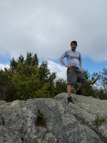
I bashed through the thick brush. The lower portions weren't too difficult, but as I ascended the higher portions were nothing but thorns and brambles. My legs got quite a thrashing, but I was able to find the highest point on the ridge. While I did not find a benchmark there, I used my GPS unit to confirm that it was indeed the summit. I spent a few minutes at a relatively clear area near the summit and took a photo there.

I then bashed through the vegetation
back to the AT where I retraced my steps by heading south. I quickly made my way to the Sarvis Cove Trail
and followed it just a short distance through some thick jewelweed
to the Horse Creek Road. I figured the road would be easier to follow than the overgrown trail.

The upper reaches of the road turned out to be interesting. There was a nice overlook of Greeneville and the surrounding countryside near a monument to a soldier whose last name was Powell.
I decided that I will call this the Powell Overlook.
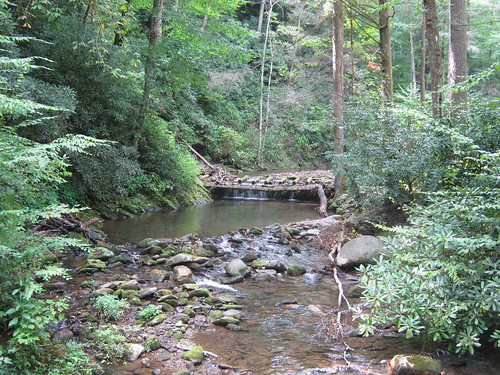
From the Powell Overlook the road switchbacked down to the upper reaches of Horse Creek. The road passed some interesting cascades
and then descended for what seemed forever. For most of my hike I did not see another person. It wasn't until the road reached the intersection with the horse trail that I saw a family our walking and soon after saw a group on horseback. It was a long hike, but I'm glad to be able to say I've been to the highest point in my new home county.

Sunday, September 15, 2013

Happy First Birthday Sierra!

What a year it's been! One year and a day ago Noelle and I were just another childless, married couple. The next day Sierra entered our lives. How she's grown in this first year of her life. Noelle and I have grown as well. We've moved from New Mexico to Tennessee and we bought a house! Here are some photos of the birthday celebrating with her loving family who drove from as far as Wisconsin and Pennsylvania!

Saturday, September 7, 2013

Blue Ridge Parkway: Craggy Gardens

After we left the Vance Birthplace we headed up into the mountains, again dodging runners (actually mostly walkers) making their way the mountains as well. Once we reached the Blue Ridge Parkway we headed north and made our way to the picnic area at Craggy Gardens. We found the Craggy Gardens/Mountains to Sea Trail at the far end of the picnic area parking lot and started hiking.
We slowly ascended our way up through deciduous trees

and goldenrods.
Eventually we found ourselves at some type of shelter or old barn.
We were a bit confused but found our way up to a grassy section of bald
with lots of great views of the surrounding mountains including nearby Craggy Pinnacle.
Eventually our trail up on the bald dead-ended and we retraced our steps back to the shelter. We passed through the shelter and found a trail on the other side. This trail gently descended through a tunnel of rhododendron and mountain laurel
down to the Craggy Gardens Visitor Center. We had thought we were on a loop trail, but this turned out not to be the case. From the visitor center we followed the trail back up to the shelter and then down to the parking area. It was a very nice, short hike. All three of us were in good spirits, in part due to the wonderful weather. Sierra also had lots of doggies to look at as there were lots of folks hiking with their dogs.

Vance Birthplace State Historic Site

It was a beautiful morning and we just had to get outside to enjoy it. We made the drive up into the mountains and across the state boundary into North Carolina. Today we would explore the Weaverville area. We started our exploration with a delicious lunch at Blue Mountain Pizza and Brewery. We got the delicious pesto pizza, a huge serving of nachos, and  some ales. I got a black IPA while Noelle got the IPA. Both were delicious. After lunch we headed to Vance Birthplace while dodging runners. Some type of relay race was going on and they didn't bother to close the road.

We toured the grounds and main home at the Vance Birthplace which interpreted the life of Zebulon Vance.
Sierra enjoyed walking barefoot through the soft grass.
It was an interesting site but definitely not as well interpreted as National Park Service sites. We fed Sierra her lunch there in the picnic shelter with a nice view of the surrounding fields and mountains
and then headed up to the Blue Ridge Parkway for the next part of our day's adventure.

Monday, September 2, 2013

Pisgah National Forest: Fork Ridge, AT, Jerry Miller Loop

It's getting to be my favorite time of the year to go hiking in the woods of eastern United States. OK, really it's my favorite time of the year to go hiking anywhere. It's the time of the year when the goldenrods
and the asters start to bloom.
And so with excitement I headed out for a hiking excursion in Shelton Laurel Backcountry Area of Pisgah National Forest. Today I would be hiking a loop on the Fork Ridge, Appalachian and Jerry Miller Trails. I made the drive through Allen Gap and took a detour to Franklin Mountain Road before finding myself at the trailhead, deep in the Carolina woods.

I parked the campsite, trailhead at Jerry Miller. There is a monument to the namesake of the trail there,
along with a nice cold deep swimming hole below some strange type of old mossy dam.
Swimming Hole
Rather than begin my hike on the Jerry Miller Trail, I opted to hike up the road a bit which paralleled the pretty Big Creek
and veer off into the woods at the Fork Ridge Trail. Hiking the road made for some fast moving and there were lots of wildflowers in bloom.
I got to see some old familiar favorites like sneezeweed and jewelweed. Soon I found a sign marking a trailhead parking area. There were three trails that seemed to start from the trailhead though. I took the trail closest to the small creek that flowed through the area and it quickly dead-ended. Next I tried the one on the far right and it proved to be a good decision.

The Fork Ridge Trail was very well maintained which was quite a relief. I made fast time on the clear trail and gentle ascent of the lower reaches of the trail. As I made my way up the mountain, the trail got quite a bit steeper. Still, it was well maintained though. Eventually I reached the Appalachian Trail. I opted to take a side trip over to the Jerry's Cabin Shelter.
I realized I had last visited this shelter during my thru-hike. It was on April 20th of 2000. It was interesting to be back, but it looked a little more run down than I remember it. There wasn't much of a register there, just a few journal pages that dated back just two days. I signed the register and ate a snack. There were lots of bees buzzing around in the jewelweed surrounding the shelter.
Soon I was joined by two gentlemen out doing a 20 mile hike. I think they were going from Devil Fork Gap to Allen Gap. It would be a long day for them and I did not envy them.

After saying goodbye to the two hikers I hit the trail again. I retraced my steps back to the junction with the Fork Ridge Trail and then continued on the AT. There were lots of flowers in bloom, especially goldenrods, asters, and jewelweed (both spotted and pale). I soon came to the section that goes over Firescald Knob which I had hiked last weekend with Noelle and Sierra. Once over the knob and off the recently relocated section of the AT I found the Jerry Miller Trail and started my descent.
The trail was a bit overgrown in sections but not in bad shape overall. Like many trails in the Appalachians, large portions of the Jerry miller Trail followed old roads.

I made my way slowly down and eventually came to a rock with a circle and cross on it.
I'd like to think it's and ancient Native American pictograph, but it's probably just an old survey mark. Just past the painted rock I left the road on a foot trail. I passed through a wet area
and then eventually descended into some old fields. The fields were overgrown and made the trail difficult to follow. I was able to make my way through the brush and was even treated to a wildflower show.
At this point the trail began to descend steeply along a cascading stream. Forest Service literature states that there is a 100 foot tall waterfall along the trail, but I did not see it. Before I knew it I was back at the trailhead, ready to return home to see Noelle and Sierra.