I got permission from Noelle to go on a solo hike today. Since the forecast called for a beautiful day, I decided I would head over to Hampton Creek Cove State Natural Area to hike a portion of the Overmountain Victory Trail up to Yellow Mountain Gap and the Appalachian Trail. It was a pleasant drive to the town of Roan Mountain. I was delayed a bit, however, by traffic in Erwin for the Unicoi County Apple Festival. Once I got out of Erwin though, the driving went much more quickly. I arrived at the trailhead off of Hampton Creek Road and got my gear ready for my hike. I passed through a gate and was on my way.
The lower portions of the hike passed through many pastures. The trail was marked with wooden posts with the Overmountain Victory Trail emblem on them.
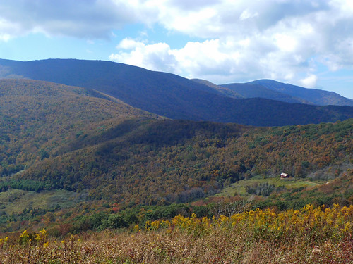
Hiking through the pastures was surprisingly pleasant though. The open, grassy areas made for great views of the surrounding mountains which are beginning to wear their fancy colors for fall. There were also lots of wildflowers in bloom. Chicory,
goldenrod,
sneezeweed,
ironweed,
and aster especially. After just a short while I passed through one of many gates and found the foundation of some type of structure.
Interestingly, despite all the deciduous trees with their leaves starting to change color, the hike reminded me of a hike one might take out west. I think it was a combination of the open grassy areas, the gates to open and close, the cow pies, and a big old cottonwood that took my mind back to hiking in New Mexico.
Eventually the trail wound its way into the woods.
Still, it was well maintained and easy to follow. I crossed a few small cascading streams and made a small descent before beginning a steep ascent up to the Appalachian Trail and Yellow Mountain Gap. I decided I would check out the Overmountain Shelter and eat a snack there. I had skipped the shelter when I thru-hiked in 2000, but can remember being able to see it from the trail. I took a short blue-blazed trail to the old barn where I ate a snack and admired the view from the front of the shelter.
After my break I made my way back to the AT and hiked a short way towards Hump Mountain to get a better view of the shelter.
Then I turned around for the descent back to the car.
It was an easy descent back down the trail. Once back in the natural area I took the Birchfield Trail instead of the Overmountain Victory Trail.
The Birchfield Trail closely paralleled the OVT, but followed closely a lovely tributary of Hampton Creek.
There were lots of little cascades and even a few deep pools.
I got to a fence and made my way back into the grassy pastures. The views opened up once again and I thoroughly enjoyed them.
I even passed through what must have been an old orchard, as there were quite a few apple trees.
As I approached the trailhead where I had started I found this cryptic sign.
I thought it was a joke at first, until I remembered that the creek here had been stocked with native brook trout and the rainbow trout had been removed. Soon I was back at the car for the drive back to Greeneville.


2 comments:
Any place to primitive camp between park boundary and AT. Barn/shelter very crowded this time of year.
Thank you
tom@albaresources.com
Tom, there is no place to camp that I can remember.
Post a Comment