It had been a long time since I had gone on a solo adventure! Today I took my opportunity to do some peak bagging in North Carolina's Black Mountains. I awoke at 6 am, walked the dog and threw my gear into the car for the drive through Weaverville, up to the Blue Ridge Parkway, and over to Mount Mitchell State Park. I parked the car at the trailhead for the Deep Gap Trail which is also known as the Black Mountain Crest Trail. This trail is where I would spend the vast majority of the next 9+ hours of my life.
The trail started with an easy, well-graded, downhill walk to a gap
and then a not-too-tough ascent of Mount Craig which I had ascended back in November. Today however, I cruised right past the summit to continue on in my quest to ascend all the 6,000 foot peaks in the southeast. Just past the summit of Mount Craig was a wonderful overlook of the rest of the Black Mountain Range.
I would be ascending all the peaks on the ridge, and from that vantage point my task did not seem all that difficult. Things were about to get a whole lot tougher though.
From the overlook on Craig I descended to a small col between Craig and Big Tom, and then asended to the summit of Big Tom. Big Tom is named for Big Tom Wilson a mountain man who discovered the body of geologist Elisha Mitchell. I snapped a quick photo of Big Tom
and then continued on heading down into another gap. Along my hike I was treated not only to wonderful mountain views,
but also glimpses of some wildflowers that had ceased blooming in the lowlands weeks ago
including several varieties of trillium.
I ascended out of the gap and up onto the summit of Balsam Cone.
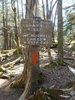
From Balsam Cone it was another descent into a gap and then an ascent up to the false summit of Cattail Peak. There is a sign indicating Cattail Peak just off to the side of the Black Mountain Crest Trail.
However, this sign is inaccurate. The true summit requires a quarter mile bushwhack up the ridge to the summit. There is supposedly a benchmark on the summit of Cattail Peak, but I could not find it. If I did not find the true summit of Cattail Peak, I must have been very close to it as I scoured the ridge twice. ( The second time being on my return hike.) After Cattail Peak it was a quick descent and then ascent up to Potato Knob.
From Potato Knob it was a long steep descent
into Deep Gap and the first legal campsites on the southern end of the trail. As I made my way down, I could see my next objective for this hike through the trees: Winter Star Mountain and its sister summit Deer Mountain.
I made my way up Winter Star and found a benchmark at the summit.
Then it was yet another descent down into a gap with a climb back out. Views opened up to my final two major objectives: Gibbs Mountain and Celo Knob.
Unfortunately, they were still a pretty long ways off. By this time I was starting to understand the difficulties of the trail. While I had read how difficult the Black mountain Crest Trail is, I really thought what I had read were exaggerations and truly underestimated the difficulty of the trek. Still, I decided to continue on.
After climbing out of the gap between Winter Star and Gibbs Mountain the views really opened up.
There were frequent high meadows off to the side of the trail. The directions to Gibbs that I had copied off the Carolina Mountain Club website were confusing and so I decided to skip the ascent of that mountain until another day. Instead I headed to Celo Knob
under a darkening sky. There is a user trail that branches off the official Black Mountain Crest Trail just past Horse Rock. This trail, though quite faint, leads to the summit of Celo Knob. I followed it to the summit where I took a break and studied the topo map to see if I could gain any new insights into finding the summit of Gibbs Mountain.
The problem with the map is that it states the elevation of Gibbs to be 5,545 feet; clearly not a 6,000 footer. I should have done more research before I left. However, on the bright side, my inability to ascend Gibbs
gives me another excuse to make a trip up into the Blacks sometime in the future.
From the summit of Celo Knob I found my way down to the Black Mountain Crest Trail and started heading back to the parking area near Mount Mitchell. I was definitely starting to feel like I had bitten off more than I could chew. I still had a long hike back to the car under increasingly dark sky
with rumbles of thunder every now and then. To make matters worse, my thighs were starting to cramp quite severely. I soldiered on though. What else could I do? Because I was so tired, I had little energy for taking photographs. I simply put one foot in front of the other and continued on as best I could. I ate my last granola bar and drank my last bit of water before I even made it back to Potato Knob, but luckily I arrived back at the car dry just after 6 pm for my long drive back to Greeneville.


1 comment:
Looks like a great hike. I've found myself on top of a mountain in a thunderstorm a couple of times. Not a good feeling at all.
Post a Comment