Wednesday, July 21, 2010
Fort Snelling
This morning I made the long drive down to the Twin Cities to explore the Fort Snelling area. My plans were to tour the fort, hike Pike's Island at Fort Snelling State Park, and then hike along the bike trail to Minnehaha Falls Park. I had great weather and was successful in accomplishing everything that I wanted to get done.
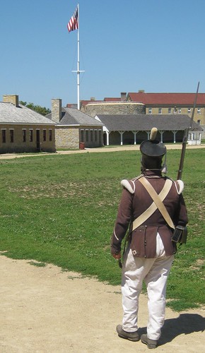
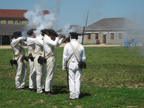
The fort itself was interesting, mostly a reconstruction of the original, but a few buildings still remain from old Fort Snelling. Probably the most interesting aspect of the tour was seeing a small group of "soldiers" march around in formation and fire their muskets.
From the fort I walked over to Fort Snelling State Park where I hiked a three mile loop on Pike's Island which like Pike's Peak is named after Zebulon Pike. The loop trail happened to be a Hiking Club Trail and so I was able to add three more miles to my total. The trail followed along the perimeter of the island and offered many views of the Mississippi and Minnesota Rivers including their confluence. There were many wildflowers found along the trail and I even saw some interesting birds including pileated woodpeckers, a wild turkey, and an egret. Not bad for a city park!
After my hike I returned to the fort, stashed some things in my car, and then followed a bicycle trail along the Mississippi River to Minnehaha Falls and a pleasant city park operated by the Minneapolis Parks and Recreation Board.
Besides the falls there were manicured gardens, historic homes, and some statues of famous people. I also stopped for lunch at a nearby Dairy Queen before returning to Fort Snelling on another bike trail.
Finally, I drove to Afton State Park on the St. Croix River where I camped for the night in the backpacking campground. Travel to the campground required a short 3/4 mile hike and the campground itself was located on top of a grassy hill with some nice views in all directions.
Thursday, July 15, 2010
The Superior Hiking Trail: The "Lost Section"
This morning was so beautiful I knew I just had to get out and do some hiking. Originally I had intended to head up to Tettegouche State Park to hike the 9 mile loop in the guide book that Noelle and I own. However, as I drove north up the Scenic Highway I just had to stop and appreciate the scenery several times. I made a stop at Brighton Beach in Duluth and then at Stony Point outside of town. When I got back on the road I noticed a sign for the Superior Hiking Trail at the town of Knife River. This is a section of trail that is not well advertised by the SHTA, and I decided I wanted to take the opportunity to find out what surprises this section of trail might offer.
From the parking lot the trail immediately followed alongside the Knife River. The water was pretty high due to yesterday's thunderstorms and so I got a view of the First Falls that was much more impressive than when I had visited them just last week.
From the First Falls the trail passed under the Highway 61 expressway. It was here that the trail wasn't quite obvious. I walked on the shoulder of the road and turned around before seeing a small SHT sign affixed to a wooden guardrail post.
On the other side of the highway the trail followed a grassy and wet path for a bit. Then I came to a trail intersection with a spur trail that led to an overlook. I decided to take the spur and was rewarded with a nice view of a serpentine bend in the Knife River.
I retraced my steps back to the main trail and soon crossed a gravel road. On the other side of the road the trail soon became more defined and showed evidence of much more use than the grassy one I had been following. I soon found myself on a section of trail I had hiked on before with Noelle, her mom and her Aunt Lisa. We had been back here to see the Second Falls back in March.
I passed the Second Falls and Coppeer Mine site and followed alongside the river for quite some time.
I found a nice place to stop along the river for lunch. It was a great lunch listening to the water cascade and my turkey with Swiss cheese and guacamole was delicious as was the nectarine I ate. After lunch the trail followed the river for a short distance before veering away and onto grassy, wet paths like the ones I had hiked earlier.
When I found myself at the eastern trail-head after 4.5 miles of hiking I decided to walk roads back to my car instead of walking the wet grass again. It was a good decision as I found a nice agate on the gravel road and also a deer skull and interesting caterpillar (actually an elm sawfly larvae).
It was also a much shorter way back to my car than following the trail back would have been.
From the parking lot the trail immediately followed alongside the Knife River. The water was pretty high due to yesterday's thunderstorms and so I got a view of the First Falls that was much more impressive than when I had visited them just last week.
From the First Falls the trail passed under the Highway 61 expressway. It was here that the trail wasn't quite obvious. I walked on the shoulder of the road and turned around before seeing a small SHT sign affixed to a wooden guardrail post.
On the other side of the highway the trail followed a grassy and wet path for a bit. Then I came to a trail intersection with a spur trail that led to an overlook. I decided to take the spur and was rewarded with a nice view of a serpentine bend in the Knife River.
I retraced my steps back to the main trail and soon crossed a gravel road. On the other side of the road the trail soon became more defined and showed evidence of much more use than the grassy one I had been following. I soon found myself on a section of trail I had hiked on before with Noelle, her mom and her Aunt Lisa. We had been back here to see the Second Falls back in March.
I passed the Second Falls and Coppeer Mine site and followed alongside the river for quite some time.
I found a nice place to stop along the river for lunch. It was a great lunch listening to the water cascade and my turkey with Swiss cheese and guacamole was delicious as was the nectarine I ate. After lunch the trail followed the river for a short distance before veering away and onto grassy, wet paths like the ones I had hiked earlier.
When I found myself at the eastern trail-head after 4.5 miles of hiking I decided to walk roads back to my car instead of walking the wet grass again. It was a good decision as I found a nice agate on the gravel road and also a deer skull and interesting caterpillar (actually an elm sawfly larvae).
It was also a much shorter way back to my car than following the trail back would have been.
Monday, July 12, 2010
Thursday, July 8, 2010
Crow Wing State Park
i woke up to beautiful blue skies this morning and cool temperatures; perfect conditions for hiking. In addition to the weather the biting insects were virtually non-existent. My hike started off following the banks of the mighty Mississippi. Fog rolled over the river and birds chirped as I made my way to the Mississippi's confluence with the Crow Wing River. Near the confluence lie the remains of the former town of Crow Wing and I enjoyed exploring and reading about the once bustling town. The only building left is the Beaulieu House, a Greek-Revival structure.
The rest of the hike followed the Mississippi into some thick, slightly buggy woods and looped back to the start. A pleasant hike of about 5 miles.
Wednesday, July 7, 2010
Mille Lacs Lake Area
Today I headed off to a part of the Gopher State that I'd never been to before, the Mille Lacs Lake area. My first stop was Father Hennepin State Park which is located on the southeastern coast of the lake. The park there was pleasant and I enjoyed the short hike on the Hiking Club trail before moving on.
The next stop on my tour was the Mille Lacs Indian Museum. The museum here is excellent and well worth the admission fee. If you go, be sure to check out the Four Seasons Exhibit which is part guided tour, part life size diorama. There is also a trading post that interprets that aspect of reservation life and offers some Indian-made goods for sale.
The next stop was Mille Lacs-Kathio State Park. The park is interesting in that there are several archeological sites located in it. I enjoyed checking out these sites and reading the interpretive panels about them.
I did not, however, enjoy the copious deer flies. Despite the cloud of insects that followed me as I walked, I was able to hike the 3.2 mile long Hiking Club trail before moving on to Crow Wing State Park and my campsite for the night.
The next stop on my tour was the Mille Lacs Indian Museum. The museum here is excellent and well worth the admission fee. If you go, be sure to check out the Four Seasons Exhibit which is part guided tour, part life size diorama. There is also a trading post that interprets that aspect of reservation life and offers some Indian-made goods for sale.
The next stop was Mille Lacs-Kathio State Park. The park is interesting in that there are several archeological sites located in it. I enjoyed checking out these sites and reading the interpretive panels about them.
I did not, however, enjoy the copious deer flies. Despite the cloud of insects that followed me as I walked, I was able to hike the 3.2 mile long Hiking Club trail before moving on to Crow Wing State Park and my campsite for the night.
Friday, July 2, 2010
Itasca State Park
Noelle and I had days off together and so we headed west to Itasca State Park. It was my second visit but Noelle's first. Regardless, we got to see a lot of cool things together including the largest White Pine in Minnesota,
the sunset on Lake Itasca,
Unfortunately, due to one of the thickest infestations of deer flies We've ever experienced we were unable to do much hiking. It makes for a great excuse to return again in the fall though!
the sunset on Lake Itasca,
Unfortunately, due to one of the thickest infestations of deer flies We've ever experienced we were unable to do much hiking. It makes for a great excuse to return again in the fall though!
Saturday, June 26, 2010
Midnight Sun Midnight Run
Last night Noelle and I braved the cool, foggy, misty night air to run in the unusual Midnight Sun Midnight Run. Like the name would suggest the run started at midnight. Unlike the name would suggest, there was no sunshine. The course was interesting, running along the Lakewalk. This made for some nice, though dark, scenery and cool breezes. However, the Lakewalk is not very wide and so the race, especially the start were quite interesting. Why is it that the slowest people on the face of the earth always flock towards the front of a 5k start? It was very interesting trying to pass people on the narrow course, especially when the race got to the point where there were runners heading in two different directions of the Lakewalk. I wasn't sure what type of time I would run, as I hadn't trained very hard for the race, but I ended up running a 19:40 5k. Noelle's time was 31:08.
Subscribe to:
Posts (Atom)