Wednesday, February 15, 2012

Big Bend National Park: South Rim Loop

Noelle and I packed up camp, ate breakfast and headed up into the Chisos Basin. The lost Mine Trail was still closed due to mountain lion activity and so we abandoned our original plan to climb Casa Grande Peak and opted to instead hike a 12.4 mile loop up to the South Rim via the Laguna Meadows, Southeast Rim, Boot Canyon, Boot Spring, and Pinnacles Trails. The weather was beautiful and the ascent up Laguna meadows was pleasant and gentle.
Noelle Hiking the Chisos
We didn't see many people on the trail, just a few trail crew members. We got lots of great views to the Window and Emory Peak
Emory Peak from Laguna Meadows
and a nice overlook of the Chisos Basin.
Eric in Chisos

Once past the overlook the trail featured rolling terrain and lots of views. We stopped at a conveniently placed restroom
Toilet
and admired some of the great views from the Rim.
Overlooking Cerro Castolon
 Noelle at South Rim
Looking Down from South Rim
parts of the Rim are closed this time of the year due to Peregrine falcon nesting.
Peregrine Closure Sign
Still, there were plenty of nice views!
Mexican Juniper
After admiring some of them we headed into Boot Canyon.
In Boot Canyon
The small canyon was surprisingly interesting and we enjoyed walking through it with its little pools of water. next we found ourselves at a nice overlook of the aptly named Boot Rock.
Boot Rock
Then we started our descent on the Pinnacles Trail. The trail was very well maintained!
Nice Trailwork
We got some really nice views of the Window again, along with Casa Grande Peak.
Casa Grande Peak
It was a wonderful end to our short visit to the amazing Big Bend National Park!

Tuesday, February 14, 2012

Big Bend National Park: Dog Canyon & Devil's Den

Chisos Panoramic
We woke up at our Grapevine Hills campsite this morning and we were treated to a wonderful view of the Chisos Mountains. We ate breakfast and got ready for the day's hike. We were headed to the northern section of the park and Dog Canyon. We had hiked Dog Canyon before on a cold, windy day. We had not, however, hiked to Devil's Den. The hike started out at a small pull-off of the main park road. We started out hiking in the baking sun. This is not a hike I would recommend on a hot summer day.

Soon we could see Dog Canyon and we headed into the wash and the canyon itself.
In Dog Canyon
It was just as I had remembered on our last visit. The canyon was impressive with lots of small caves in its limestone walls. We traveled clear through the canyon and then turned around to head for Devil's Den. The hike to Devil's Den followed a dry, narrow wash.
Hiking Wash

The hike wasn't really all that interesting until we came to a section of the wash that featured a solid rock floor. There were some potholes where water had carved right through the rock. One of the potholes had formed a small natural arch.
Devil's Den Arch

We headed further up the wash and could soon see Devil's Den Canyon itself.
Devil's Den
The canyon features a lot of boulder hopping and climbing.
Boulder Hopping
We weren't really prepared to do a lot of climbing and so we went into the canyon just a little ways where we stopped and rested before heading back out. We found a short cut back to the car, a cairned rock across the desert.
Noelle and Distant Dog Canyon
Soon we were back to the car. We still had plenty of daylight and so we decided to take our time driving back to camp. We stopped at the Fossil Bone Exhibit and admired the view.
Fossil Bone Overlook
Then we headed to the Hannold Grave site.
Hannold Grave

At this point we were a bit conflicted about what to do with the rest of our day. Finally we decided to head to the Terlingua Ghost town for dinner at one of our favorite restaurants ever, the Starlight Theatre.
Starlight Theatre
We got into town a bit early and so we explored the remains of the old mining town a bit before we headed into the restaurant for a delicious dinner.  
Eric in Terlingua
Mine Elevator

Monday, February 13, 2012

Big Bend National Park: Cattail Falls

Yesterday, despite the forecast of a winter mix, Noelle and I pointed the Subaru south and headed for the Big Bend of the Rio Grande. We hit a little bit of freezing rain north of Pecos, Texas but we made it as far as Alpine, TX where we spent the night. This morning we awoke and ate breakfast at McDonalds. My first time eating at this fast food establishment in about 7 years. There just aren't many restaurant options in Alpine.

Anyway we drove through a light drizzle and fog through the disjointed, small mountain ranges of West Texas before we entered Big Bend National Park by 10. After paying our entrance fee we headed straight to a rough road and the secret trailhead for Cattail Falls. As we began our hike our spirits were high and the fog started to lift from the Chisos Mountains.
Chisos Fog
 The hike followed an old road and soon entered some trees where there seemed to be a little bit of flowing water. We found the "tie-down tree" I had heard about
The Tie-Down Tree
along with a sign warning us not to hike with small children due to the recent mountain lion attack.
Mountain Lion!
We then proceeded to hike on the trail gradually uphill. More and more fog began to burn off and the sun shone warm as we headed into some trees and approached the falls.
Hiking Out of Fog
In the Trees

While the falls were just a trickle there was plenty of water in the pool at the bottom of the pour-off.
Bottom of Cattail Falls
The whole area was a wonderland of ferns and cool, moist air.
Maidenhair Ferns
We enjoyed the scene for a bit before turning around and heading back to the car.
Hiking Back from Falls
 We savored our first taste of Big Bend in about seven years and were ready for some more!
   

Big Bend National Park: Pine Canyon

When we were in the planing stages of this Big Bend trip one of my co-workers who had formerly worked at Big Bend National Park recommended the hike into Pine Canyon. I was worried about the road access but he assured me that the Subaru would be able to make it. I'm really glad we took his advice. The hike up into Pine Canyon was truly magical.

Agave

The hike started with a drive along the rough Glenn Springs and Pine Canyon Roads to the trailhead. The trail didn't start out looking too promising, just a walk through the sotols, cactus and desert grasses.
Beginning of Pine Canyon
Soon we started to see some trees though. The deeper into the canyon we headed the more trees and shade we found. There were oaks, madrones, pines, and even maples.
Trees!
Noelle in the Trees

The mixture of trees reminded me a bit of the Guadalupe Mountains. Eventually we found ourselves at the bottom of a massive dry pour-off.
Bottom of Pour-off
We rested there for a bit and then headed down canyon.
Resting
The views to the southeast and into Mexico were amazing.
Hiking Down Pine Canyon
There were lots of interesting rock formations along the sides of the trail as well.
Rock Outcrops
Rock Outcrop

The hike back to the car was downhill and easy. The whole hike was thoroughly pleasant. The scenery wasn't eye-popping but just enjoyable. We remarked on how different the hike got from the start to the pour-off. It was like two different worlds. Once we returned to the car we headed back out on the rough roads and headed to our home for the next two nights: Grapevine Hills site #3.
Eating Dinner
We relaxed and ate dinner before retiring for the night. It was a great way to spend a day in Big Bend National Park! 

Tuesday, February 7, 2012

Guadalupe Mountains National Park: Bartlett and Shumard Peaks

This morning was cold and gray. I woke up, ate two granola bars for breakfast and then packed my lumbar pack for a day of bushwacking the slopes of the Guadalupes. I hit the trail just after 7 and was treated to the sunrise poking through the clouds.
Sunrise
 Then I stepped off trail and the fun began. The descent into Pine Springs Canyon wasn't too bad. I followed a game trail for part of the way. The climb was rough, but not as bad as I had expected. It took me just over an hour to get myself to the summit of Bartlett Peak. I signed the register there and took a self-portrait before moving on again.
Bartlett Register
Bartlett Summit

It was a steep descent to the drainage between Bartlett and Shumard Peaks.
Ridge
I mostly followed the ridge with a steep drop off down to the salt flats and gypsum dunes. When the climbing started it was rough going. I stopped for a short break and to admire the views down on the flats and over to Guadalupe Peak and El Capitan.
Guad Peak and El Cap
Soon I was on top of Shumard Peak.
Shumard Summit
It took me just over two hours to ascend both peaks from the Bush Mountain Campground. I ate a snack, snapped some photos and then started to make my way down. I decided to descend via a different route. Instead of climbing up some of the little knobs on the ridge, I decided to bypass the ridge altogether and contour around Bartlett Peak.
Bartlett Peak

My bypassing of the ridge turned out to be a mistake. My shins were getting shredded by the vegetation. It wasn't so much the cactus and yucca, as it was the scrub oak. As I turned the corner around the southern flank of Bartlett Peak I realized I would have to descend much lower into Pine Springs Canyon than I had anticipated. I crossed the canyon bottom and then headed up a ridge, eventually finding myself back on the Bush Mountain Trail. I made my way back to the campsite where I rested for a bit before packing up camp and heading back to the car.
Hunter Peak
 I was thoroughly exhausted when I fished the keys out of my pack and headed back to Carlsbad.  

Monday, February 6, 2012

Guadalupe Mountains National Park: Pine Springs to Bush Mountain Campground

With excellent weather forecast for my days off I decided to head over to Guadalupe Mountains National Park and give the ascent of Bartlett and Shumard Peaks a try. My plan was to backpack up to Bush Mountain Campground and set up camp for an early morning attempt on the two peaks tomorrow. And so, I headed down into Texas and got my backcountry permit. The hike started out easy enough, with a gradual ascent up the Tejas Trail.
Backpacker Eric
I was making pretty good time. I turned onto the Bush Mountain Trail and soon I could see one of my objectives for tomorrow: Shumard Peak.
Shumard Peak
 A look back revealed a nice view down Pine Springs Canyon and to the desert flatlands below.
Looking Toward the Desert
I was in no hurry as I had plenty of sunlight to get to Bush Mountain Campground, so I was able to take a short nap on the trail.
Napping 
I arrived in camp with plenty of time. I decided on campsite 3. 
 Bush Mountain Campsite 3
I set up camp and then took some time to look at my map and study my route for tomorrow. 
Campsite
Map for Planning

Wednesday, February 1, 2012

What's Your Spirit Animal?

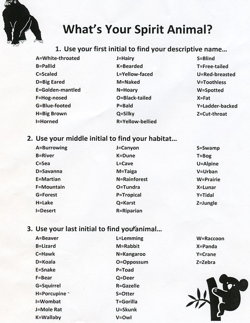
One day last week at work, myself and some of the other rangers were, for some reason or another, infatuated with "spirit animals". We decided that we needed to figure out what each ranger's spirit animal was. In some cases the choice was based on perceived resemblance, but mostly it was based on personality. Then later in the week someone passed around a sheet that promised to show you what your "blues name" was. I decided to modify the "blues name" sheet and create a "spirit animal" one.
Spirit Animal
This is the result. So, what is your spirit animal? My initials are EAG and so my spirit animal is the Golden-mantled Burrowing squirrel.