Tuesday, February 7, 2012

Guadalupe Mountains National Park: Bartlett and Shumard Peaks

This morning was cold and gray. I woke up, ate two granola bars for breakfast and then packed my lumbar pack for a day of bushwacking the slopes of the Guadalupes. I hit the trail just after 7 and was treated to the sunrise poking through the clouds.
Sunrise
 Then I stepped off trail and the fun began. The descent into Pine Springs Canyon wasn't too bad. I followed a game trail for part of the way. The climb was rough, but not as bad as I had expected. It took me just over an hour to get myself to the summit of Bartlett Peak. I signed the register there and took a self-portrait before moving on again.
Bartlett Register
Bartlett Summit

It was a steep descent to the drainage between Bartlett and Shumard Peaks.
Ridge
I mostly followed the ridge with a steep drop off down to the salt flats and gypsum dunes. When the climbing started it was rough going. I stopped for a short break and to admire the views down on the flats and over to Guadalupe Peak and El Capitan.
Guad Peak and El Cap
Soon I was on top of Shumard Peak.
Shumard Summit
It took me just over two hours to ascend both peaks from the Bush Mountain Campground. I ate a snack, snapped some photos and then started to make my way down. I decided to descend via a different route. Instead of climbing up some of the little knobs on the ridge, I decided to bypass the ridge altogether and contour around Bartlett Peak.
Bartlett Peak

My bypassing of the ridge turned out to be a mistake. My shins were getting shredded by the vegetation. It wasn't so much the cactus and yucca, as it was the scrub oak. As I turned the corner around the southern flank of Bartlett Peak I realized I would have to descend much lower into Pine Springs Canyon than I had anticipated. I crossed the canyon bottom and then headed up a ridge, eventually finding myself back on the Bush Mountain Trail. I made my way back to the campsite where I rested for a bit before packing up camp and heading back to the car.
Hunter Peak
 I was thoroughly exhausted when I fished the keys out of my pack and headed back to Carlsbad.  

Monday, February 6, 2012

Guadalupe Mountains National Park: Pine Springs to Bush Mountain Campground

With excellent weather forecast for my days off I decided to head over to Guadalupe Mountains National Park and give the ascent of Bartlett and Shumard Peaks a try. My plan was to backpack up to Bush Mountain Campground and set up camp for an early morning attempt on the two peaks tomorrow. And so, I headed down into Texas and got my backcountry permit. The hike started out easy enough, with a gradual ascent up the Tejas Trail.
Backpacker Eric
I was making pretty good time. I turned onto the Bush Mountain Trail and soon I could see one of my objectives for tomorrow: Shumard Peak.
Shumard Peak
 A look back revealed a nice view down Pine Springs Canyon and to the desert flatlands below.
Looking Toward the Desert
I was in no hurry as I had plenty of sunlight to get to Bush Mountain Campground, so I was able to take a short nap on the trail.
Napping 
I arrived in camp with plenty of time. I decided on campsite 3. 
 Bush Mountain Campsite 3
I set up camp and then took some time to look at my map and study my route for tomorrow. 
Campsite
Map for Planning

Wednesday, February 1, 2012

What's Your Spirit Animal?

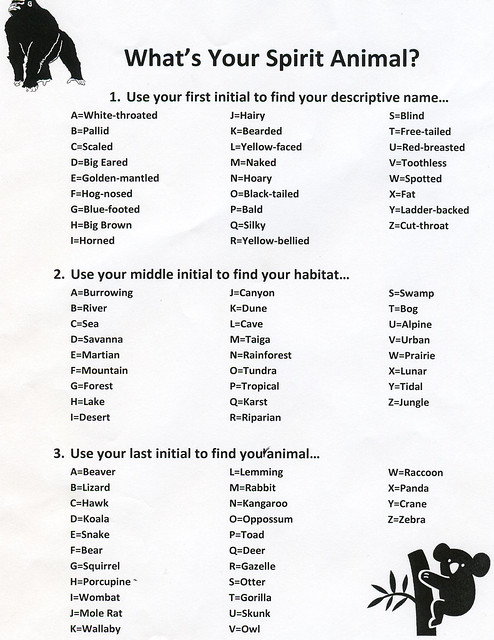
One day last week at work, myself and some of the other rangers were, for some reason or another, infatuated with "spirit animals". We decided that we needed to figure out what each ranger's spirit animal was. In some cases the choice was based on perceived resemblance, but mostly it was based on personality. Then later in the week someone passed around a sheet that promised to show you what your "blues name" was. I decided to modify the "blues name" sheet and create a "spirit animal" one.
Spirit Animal
This is the result. So, what is your spirit animal? My initials are EAG and so my spirit animal is the Golden-mantled Burrowing squirrel.

Tuesday, January 31, 2012

Lincoln National Forest: North McKittrick Canyon

I'm always looking for new places to hike that aren't too far away. I've spent a lot of time on the Lincoln National Forest website looking for ideas about new places to go. There was a trail listed in the Guadalupe Ranger District that has particularly interested me: the North McKittrick Canyon Trail. Today I decided, was the day to check it out. I hit the road a little before 8 am and headed up to Queen and the Guadalupe Ridge Road.

My hike started out easy enough. I followed the rough road that Noelle, Parker and I had followed for our hike into Devil's Den Canyon. Most of the snow from the previous trip had melted and most of the mud had dried up as well.
Hiker Eric
I made quick time past the turnoffs to Devil's Den and Camp Wilderness Ridge.
McKittrick Sign
I followed the rocky, rough road until it dead-ended at a high spot overlooking El Paso Gap and the highest reaches of North McKittrick Canyon.
Juniper
North McKittrick Canyon
There wasn't any trail there though. I did see a few cairns though, so I followed them for a bit before they seemed to disappear. It looked like I would be doing some bushwacking.

I quickly headed down into the drainage of North McKittrick Canyon. I found lots of animal bones there including a deer skull complete with a nice set of antlers.
Deer Skull
It was rough walking in the canyon because of the thick vegetation. Eventually, as the canyon got deeper and side canyons joined it, there was less vegetation and hiking got a bit easier.
Inside North McKittrick

It was still not a "walk in the Park" though. The hike involved a lot of boulder hopping and I found my feet hurting a little bit after just a short while. I did find a few Permian age fossils on some of the limestone boulders though.
Fossil

As I made my way further down canyon the scene got a bit more interesting. There were several springs, seeps and tinajas. One of the more interesting ones was a deep tinaja filled with blood-red water.
Red Tinaja
Further down-canyon still was the most interesting spot of the hike. There was a large rock shelter that evidence told me is frequently used as a campsite. There were some pictographs inside the shelter.
Faded Pictographs
Pictograph
Just past the shelter was a false arch, a huge slab of limestone leaning against the canyon wall.
False Arch
Here I also found a nice flowing spring seeping out of a crack in the rock. I wanted to spend some more time exploring, but the day was starting to get late and I didn't want to get caught in the canyon after sunset. Reluctantly, I turned around and headed back up the canyon.

The hiking up the canyon went surprisingly quickly. I stopped a few times to take breaks, but generally I moved at a nice steady pace.
Madrone Chair
I was making great time and hopping over some boulders when I realized that my camera was no longer in my pocket. I checked my pack even though I didn't remember putting it in there, but there was no camera. I figured that the camera was lost forever. Finding it in the long, boulder-choked canyon would be like finding I needle in a haystack. Should I even bother going back to look for it? I thought about for two minutes and decided to go back. I left my pack and ran. After about a quarter of a mile I saw my blue camera hanging from the branch of a small maple tree. I guess as I was tramping through the vegetation the loop got caught in the branch and slipped out of my pocket without me even feeling it. I felt great relief as I slipped the camera back into my pocket and made my way back to the car.

Monday, January 30, 2012

Guadalupe Mountains National Park: Bear Canyon & The Outer Bowl

Noelle, Chris, Robby, Erin, Tess, Nigel and I had a great breakfast at Pecos River Cafe this morning before we bid farewell to Erin and the kids and hit the road and heading for Guadalupe Mountains National Park. Our objective was to hike up Bear Canyon, a trail so ferocious that it made Noelle cry the first time we hiked it in late 2002. Once we made it to the top of the ridge we figured we would hike the outer loop of the Bowl on the Juniper, Tejas, and Bowl Trails. We figured it would complement last week's hike well.

The hike started out with an easy ascent along the base of the escarpment on the Frijoles Trail.
Three
When we hit the Bear Canyon Trail the hiking got a bit more difficult.
Robby Hiking Up Bear Canyon
It was a steep uphill climb. Much of the trail followed a pipe that I presume once carried water from the top of the mountain to the desert below.
Pipe
We stopped to take our first break in a nice sheltered spot amongst some rocks.
Taking a Break
Nearby was an interesting little tunnel that the trail traveled through.
Tunnel
Then it was more steep hiking and switchbacks up to the ridge.

When we arrived on top of the ridge we followed the Bowl Trail that we had hiked last weekend. There was a little less snow than last week, but in some sections there was still enough left that it made the hiking a bit more difficult.
In the Trees
Chris put on his ice spikes, mostly just to say he finally got to use them.
Ice Spikes
We stopped at a nice grassy spot along the Juniper Trail and ate some snacks and rested.
Eric
I even fell asleep for a few minutes in the warm sun. Noelle enjoyed the break and felt refreshed.
Refection in Glasses
Then it was back into the trees, shade and snow.
More Snow


We passed by several old stock tanks on our hike.
Tank
There were lots of great views!
Robby Hiking Away
We even found a few fossils in the limestone.
Brachiopod

Eventually we made it back to Bear Canyon and started to make our way down.
Looking Down Canyon
Climbing Over Pipe
The descent went much faster than the climb and before we knew it we could see Nipple Hill and the cars.
Hiking to Nipple Hill
Altogether it was a great 11.5 mile hike!

Tuesday, January 24, 2012

Carlsbad Cemetery

It was a busy day today, and so I didn't have a whole lot of time for a real adventure. I did, however, take the time to explore the Carlsbad Cemetery a little bit. The goal of my exploration was to see the graves of a few local celebrities that played an important role in the development of my workplace: Carlsbad Caverns National Park.

My first stop was a search for the grave of James Larkin White.
Jim White Grave

His headstone declares that he was the discoverer of Carlsbad Cavern, but Native Americans had known about the cave entrance long before Jim White ever happened upon it. Still, he deserves a great deal of credit for discovering many of the rooms and chambers in the cave's dark zone.

My second visit was to the grave of Colonel Thomas Boles, the first superintendent of Carlsbad Caverns National Park.
Colonel Boles Grave

Colonel Boles is well known for his dramatic methods of encouraging visitation to the caverns and lobbying for funding.

Finally, I attempted to find the grave of Enis Creed "Tex" Helm. Tex was a well known photographer who is famous for his 1952 photo, called the "Big Shot", of the Big Room of Carlsbad Caverns. This photo used over 2,400 flash bulbs to illuminate the Big Room and was sponsored by the Sylvania Company. unfortunately I was unable to find his grave. I guess it gives me another chance for a micro-adventure on another busy day when I'm stuck in Carlsbad. 

Thanks to former park historian Bob Hoff, who inspired me to embark on this adventure via his Carlsbad Caverns History Blog.

Monday, January 23, 2012

Guadalupe Mountains National Park: The Bowl

This morning at 7:45 Robby arrived at our house for our trip to Guadalupe Mountains National Park. After a stop to pick up Helen, we were on our way into Texas and the beckoning trails of GUMO. We arrived at the trailhead parking lot at about 9:00 and quickly hit the trail. It was an easy start to the hike, but things got a bit tougher as the trail steepened.
Three Hikers
GUMO Hikers

After about 45 minutes on the Tejas Trail, Helen decided that she didn't want to slow us down and so Robby, Noelle and I moved ahead without her. We decided we would reunite at the junction of the Tejas and Juniper Trails after we had hiked the inner loop of the Bowl.

We missed Helen's companionship, but we were able to move a little bit more quickly without her. It was a perfect day for hiking. Not too hot and not too windy. Soon we passed above the Hiker's Staircase where Noelle and I had hiked with my brother Kris about 2 weeks ago. 
Limestone Tower

We got lots of great views of Guadalupe Peak and the other peaks of the Guadalupes.
Robby on the Trail
Noelle on the Trail

Soon we were at the top of the escarpment. We had anticipated hiking in the snow, but there was more than we had expected.
Hiking a Snowwy Bowl

After some time alternately sliding and slogging through the snow, we found ourselves at the top of the very steep Bear Canyon Trail.
At the Top of Bear Canyon

Noelle and I had hiked that trail nearly 10 years ago, and the trails steepness left Noelle in tears. I think she would agree that she is a much tougher hiker now than she was back then. After passing the trail junction we found an old stock tank.
Robby Tanking Up

Then we moved onto a high meadow area dotted with ponderosa pines that I found reminiscent of the Black Hills.
Robby in the Bowl

Robby, Noelle and I found a nice dry section of grass, sheltered from the wind that made a great spot to relax for a few moments.
Robby & Eric Resting

When we resumed our hiking we had some more snow to contend with. Soon we could see Helen again. We stopped and rested with her and ate some snacks before heading back down.

The hike down was nice and easy.
Hiking Down

The miles seemed to fly by. We still stopped to take another rest at about the halfway point of our descent.
Hiking Break

Before we knew it we were back at the parking lot. The whole hike was, in the words of Robby, incredi-bowl!